

DJln491
-
Posts
631 -
Joined
-
Last visited
Content Type
Profiles
Blogs
Forums
American Weather
Media Demo
Store
Gallery
Posts posted by DJln491
-
-
meanwhile I'm dry slotted with maybe 7-8"

-
11 minutes ago, OrangeCTWX said:
Jim Cantore just got thunder snow twice live on TWC lol
Love it. Did he go berserk?
-
 1
1
-
-
That counterclockwise rotation I think even WOR should get some of the goods in the coming hours
-
Just dumping right now in W Hartford let’s hope it continues
-
some people are going to get a foot of snow and be pissed
-
1
-
 1
1
-
 1
1
-
-
Just enough to cover up the visible dog pee in the snowbanks. we take
-
1
-
1
-
-
How bout them 00z runs tonight?! Interesting for sure
-
1 minute ago, WeatherGeek2025 said:
I will have a snowmap ready by tomorrow afternoon for anyone that's interested.
Start high. But dont worry, we can always go higher
-
1
-
1
-
-
-
28 minutes ago, Prismshine Productions said:
18z v 12z


Sent from my SM-S166V using Tapatalk
Stronger but easterer
-
Dumping in W Hartford right now
-
Just now, DomNH said:
It’s absolutely pounding but it’s baking powder.
Same here in W. Hartford. some larger flakes getting mixed in. Around 12" so far. Loving it personally, no complaints.
-
7 minutes ago, WxWatcher007 said:
Mom reports 7.5” in East Hartford. Hope she’s not slant sticking
but pictures look good.

I’m in W Hartford and just measured the same. It was pretty darn close to 8”
-
2
-
-
Those bands that came thru CT look like they’ve amped up even more heading towards Boston
-
1
-
-
eyeballing 2" or so in W. Hartford
-
take em down for CT
-
 1
1
-
2
-
-
2 minutes ago, Prismshine Productions said:
Do we even have a nickname for the RRFS yet? Seems we got one for all the others
Goofus- GFS
King/Dr.No- Euro
Reggie- RGEM
ICONic- ICON (Looking at you Astronomer)
Uncle- UKMET
Nammer- NAM
(And I personally call the GEM "Ol' Timbits")
Sent from my SM-S166V using Tapatalk
Rufus
-
1
-
-
23 minutes ago, Mo Snow said:
Wish the Patriots were hosting. Would've been an all timer snow game on Sunday
damn week 1 loss to the Raiders
-
1
-
-
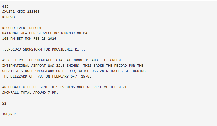
URGENT - WINTER WEATHER MESSAGE
National Weather Service Boston/Norton MA
1144 AM EST Thu Jan 22 2026


...WINTER STORM WATCH IN EFFECT FROM SUNDAY MORNING THROUGH MONDAY
EVENING...

* WHAT...Heavy snow possible. Potential for snow accumulations
  between 6 and 12 inches, with localized accumulations over 12
  inches possible.

* WHERE...Southern New England.

* WHEN...From Sunday morning through Monday evening.

* IMPACTS...Roads, and especially bridges and overpasses, will
  likely become slick and hazardous. Plan on slippery road
  conditions. The hazardous conditions could impact the Monday
  morning and evening commutes. Travel during the Monday morning
  commute is likely to be very difficult.
-
close to 1" in W. Hartford and still moderate snow
-
1
-
-
In Cromwell at the moment big flakes falling surfaces starting to cover
-
Light snow still falling here just west of Hartford. It wont amount to much but keeps the mood going. Glad to hear eastern folks are getting in on it...
-
Winding down in W. Hartford. Snow globe flakes for the past few hours...maybe another 1.5" inches for a total of 3". Nice wintry look out there
-
NWS shrugging it's shoulders
-
2
-
The Allsnow Blizzard of 2026
in New York City Metro
Posted
congrats fellas, what a monster