

Cartier God
-
Posts
47 -
Joined
-
Last visited
Content Type
Profiles
Blogs
Forums
American Weather
Media Demo
Store
Gallery
Posts posted by Cartier God
-
-
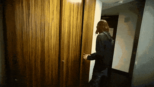
Yesterday’s chase started after leaving a party at my boss’s house around 6:30. Storms began to fire southwest of the warm front around 6:40, looking pretty anemic at first. Still on the fence about chasing, I drove to Staples in Frandor to stop and check mesoanalysis. Soon after I noticed a small cell east of Dewitt that was broadly rotating on radar. I drove north to get a view of the storm at 7:10. Shortly after I caught a glimpse of the distant updraft base.

As I approached the storm from the southwest, the RFD clear slot became more apparent, and a broadly rotating wall cloud could be seen.
After heading east to get a better view, I witnessed the old updraft base move off to the north and begin to occlude. Off to the south, a new and more vigorous updraft was wrapping up. I cautiously drove east behind the storm. After the trees parted, I was greeted with a closer view of the mesocyclone looking ENE on Bath Rd.
The RFD surge was mesmerizing. A tornado looked imminent. I noticed wispy funnels emerging from the mesocyclone about 3 miles west of perry accompanied by rapid upward motion. I continued east as my view of the ground became obscured by trees. I stayed west of I-69 not wanting to risk getting too close or missing out on the storm structure. A weak tornado was visible at this point, lofting small debris.
The funnel quickly widened and intensified after crossing I-69.
I repositioned and gained sight of the tornado after stopping at the intersection of Bath and Ruess. I watched the now uncondensed funnel cross Ruess Rd, with a brief power power flash and some swirling debris noted.
I continued east and witnessed a few more ragged lowerings before calling it a night and heading home at dusk.
.-
 12
12
-
-
Was on this storm for nearly an hour and a half last night, watching it change from a weakly rotating updraft base to a large and damaging tornado as it entered Perry. Followed it from the west on Bath rd, witnessed lofted debris and power flashes as it crossed Ruess rd. Will post more pics after work
-
3
-
-
3 hours ago, Torchageddon said:
Is it true MI hasn't seen an EF4+ tornado since 1974/1975?
HRRR isn't giving me anything concrete atm.
The last tornado to be rated F4/EF4+ in Michigan was actually a little later, in April 1977. Two F4 tornadoes struck Kalamazoo and Eaton counties respectively. Still been an insanely long streak.
I have to work up in Grayling today, otherwise I would fs be chasing today.
-
1
-
 1
1
-
-
what's up with the 00z HRRR for tomorrow? really diminishes the severe threat for MI compared to 18z.
-
30 minutes ago, frostfern said:
Strong flow at 925 can mitigate negative effects over the lake. If there's enough surface backing there can be some enhancement. The southeastern side looks most favorable though. I get the feeling there will be broken initiation along the lake breeze, like right along 131, that then fills in and grows as it moves east.
see April 3 1956. multiple supercells went surface-based and tornadic the instant they crossed the lake. not saying tomorrow will be anything like that, but it is possible this time of year.
-
6 hours ago, WaryWarren said:
I lived in northern Italy for awhile. There were days in January where the palm trees were weighed down with wet snow. Love that memory.
ghost of kyiv reference
-
got thursday and friday off work, wish i could stay in lansing for the event but we’ll see how detroit fares. i’d be happy to get 6” out of this
-
2 hours ago, Natester said:
0z ICON east of 18z.
me returning from my year long hiatus after natester mentions the icon
-
1
-
 3
3
-
-
I'm scheduled to work here in Lansing Thursday and Friday, and I was planning on driving home to Detroit Friday evening. Something tells me my schedule will be changing.
-
i fly back to detroit from albuquerque friday so not sure how i feel about the timing of this one
-
snow is finally falling here in east lansing. solid rates right now
-
1
-
-
final call 8 inches, as a weenie hut general im obviously manifesting another northwest trend atm
-
ended with just under a foot of snow here which exceeded my call of 10.5", never count out the holy northwest shift. almost considered driving home to my parents house in wayne county when it was looking like we'd be on the north side of everything, pretty glad i didn't. super solid storm here, ill post pics later today.
-
1
-
-
final call 10.5 inches. ready 2 reel
-
5 minutes ago, zinski1990 said:
Anyone have euro kuchera totals? Just for curiosity in Indy
-
5
-
-
1 hour ago, Stevo6899 said:
Im actually a florida snowbird now. Perhaps getting out of that shitty climate once in awhile will make you a happier person. Nobody saw over 5 in yesterdays clipper, let alone 6-7 as you said. Just calling it like i see it. Nobody calls out joshs turd polishing so i do it. If he did it less i wouldnt need to troll him so often. Same with joes bullying. I wasnt up north last year so perhaps I missed this big dog alek is talking about, but my guess was it for the chicago region and it weakened as it approached dtw. Just the way it is mostly as dtw is often stuck in the transfer energy to the east coast zone. Other than that, nobody can deny the trend for storms to weaken as they head east the past 3-4 winters. Havent had a ghd type, nw trender is awhile. Not sure why I need to take a seat for calling it like i see it. Anyhoo y'all enjoy your useless cold and dry.
So last 5 years, dtw is averaging less than 1 storm a yr that drops 9". Thats terrible. Thats gotta be below almost all other areas in the region.
terrible bait 0/10
-
1
-
-
3 minutes ago, buckeye said:
...oh that's right, the weird hardon and snark that some of you have for Ohio posters.
yes its because people from ohio dont understand jokes
-
ill be home in grosse pointe for this event so naturally im mclovin the south trend
-
1 minute ago, brianc33710 said:
Wild Ass Guess
Oh okay. I was just explaining why it was wrong. I’ve seen a couple weenies online push this conspiracy and its complete bs. The ratings for this outbreak were egregious but acting like its some scheme for WFOs to deny people who lost their homes financial aid is ridiculous.
-
1
-
-
15 minutes ago, brianc33710 said:
This was just a WAG trying to figure out why they seem so reluctant to rate tornadoes an EF5. Most members here, many of them meteorologists, find the damage on par with 27 April 2011s EF5s. Even then though there were EF4s that many experts believed should be EF5s & at least a couple EF3s that some argue were EF4s. As I said, a WAG.....thats all.
What does WAG mean
-
19 hours ago, brianc33710 said:
Would these "underratings" relate to insurance companies and/or aid groups that dole out more aid for 5s than 4s & dont want to give out more money? Im being serious, not a smart ass.....just want to make sure this comment isnt read the wrong way.
I think you have a misunderstanding of how insurance companies provide compensation for natural disasters. It’s based off the cost of insured losses, not EF rating.
-
5 minutes ago, brianc33710 said:
Thats decent placement on the SPCs part but maybe they shouldve enlarged moderate N & E and issue a High Risk where the Mod is?
The SPC did an excellent job forecasting this event, especially given short-term model guidance that day. It wasn't until around 16z Friday when the CAM runs began to catch on to the overperforming surface temps/dews and started to realize the nightmarish potential of that day. The SPC also did an amazing job with their timely and descriptive MDs as the event unfolded. It's easy to say that they could've gone with a high risk after everything is said and done, but given the model guidance and general expectations for Friday its fair to say that they did a fantastic job.
-
1
-
-
38 minutes ago, michsnowfreak said:
Why do I not remember what this stands for lol? Warm & dry?
Warm air damming? lol
-
I got off work at 4 yesterday tired as hell and knowing I couldn’t make it to the thumb in time, so I took a nap and then I raced to meet the embedded supercell that dropped a tornado near White Lake. I stopped near Sylvan Lake just after the updraft occluded, but I still saw a grungy looking shelf with some cool striations. It was a decent chase but not as nice as the one I had on 6/26.
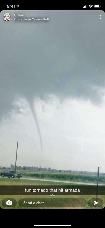
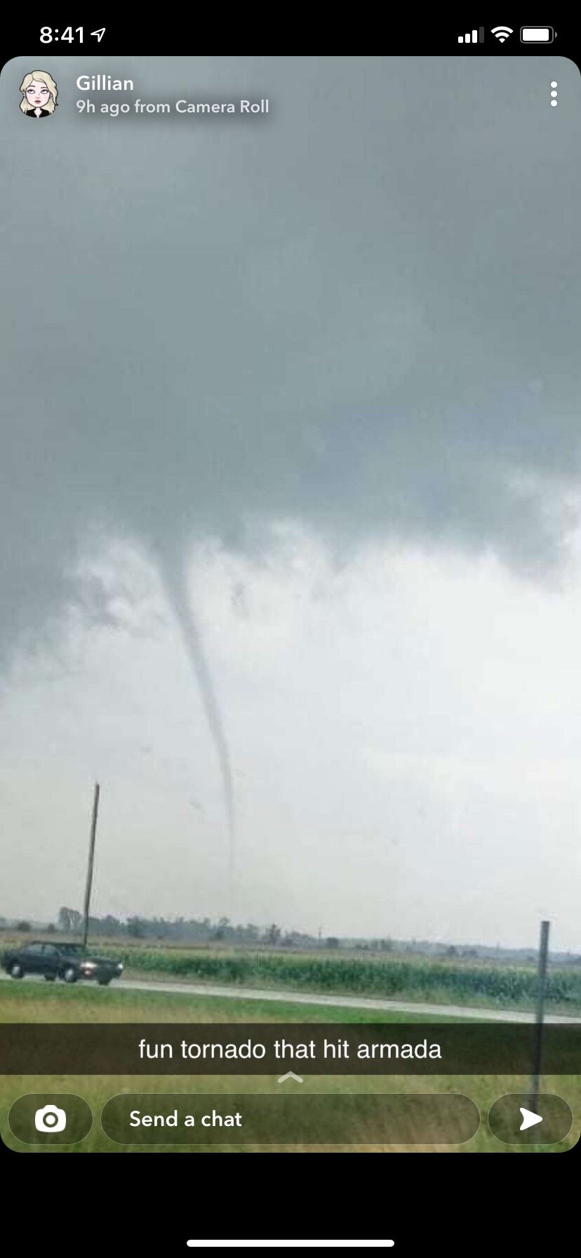
This picture is of the tornado that hit Armada, from a friend of my girlfriend. Her house was ok but other houses on her street sustained damage.
-
1
-
April 16-17 Severe Weather Event
in Lakes/Ohio Valley
Posted
First chase of the year locally today, saw a tornado warned supercell while stopped northeast of Eaton Rapids.


.