

Scottie16
-
Posts
91 -
Joined
-
Last visited
Content Type
Profiles
Blogs
Forums
American Weather
Media Demo
Store
Gallery
Posts posted by Scottie16
-
-
3 minutes ago, Carvers Gap said:
Say what we want about the lack of snow, but the 18z GFS is straight bringing the cold.
I don’t think any WWA will survive this front.-
 1
1
-
-
3 minutes ago, TellicoWx said:
Nice hit west of the plateau on the 18z GFS..think you guys in that area are in a good spot.
I’m still weary on the models not handling how quick the temperatures will drop. We are going to have some really breezy conditions Mid-Thursday in Friday morning. I’d be happy with a dusting at this point though.
-
1
-
-
31 minutes ago, Carvers Gap said:
The 18z GEFS looks awfully similar to the 12z GFS...awfully similar.
Definitely going to stay up late to catch the next GFS. It’ll be interesting to see if it follows its current trend or flips back.
-
1
-
-
Playing with the sounding and these potential wind speeds are going to bring bone chilling wind chills.
-
3 minutes ago, John1122 said:
It's liable to be way off but it did this in March this year when the Euro was reluctant to get on board at this range.
Seems like the UKie is following the GFS trends too, yeah?
-
7 minutes ago, Vol4Life said:
Unless I’m looking at the wrong run, the 26-27th look dry and cold to me
I’m looking at the wrong run because I’m an idiot. Apologies.
-
1
-
-
4 minutes ago, Carvers Gap said:
Well, someone feel free to post the Kuchara map. Whoa.
Looks like the second system (26th-27th)is setting up nicely with that run too.
-
We ready to create a thread for this system or?
-
20 minutes ago, TellicoWx said:
Had quite a few wrecks on the river road...Rescue Squads 4x4 has to take EMS up with them
North river was bad
-
1
-
-
35/33 here in Maryville.
-
Just now, Shocker0 said:
It's definitely a very wet snow. I really can't believe it's snowing based on the radar. It shows rain and everywhere around us as rain. I am at 1980ft elevation though. I'll check back in an hour and see if it's still doing it.
Looks impressive! Radar is starting to show it changing over now, even for the lower valley.
-
1
-
-
Sleet mixed in for a quick second than changed back over to rain. Seems like the warm nose won’t prevail this time.
-
I’m at 38.8/33.6
-
1
-
-
Smallest raindrops possible on my way into work. Temp at 38.
-
1
-
-
Strong winds out of the north in Maryville. Currently 39 at my location.
-
1
-
-
3 minutes ago, John1122 said:
The GFS is just all in. It's either gonna bust wide open or score big. 13 inches imby that run.

Reading the latest guidance MRX is all in on the NAM.
-
7 minutes ago, Jesse from KY said:
What is everyones thoughts on snowfall and/or ice fall for Bell County (2 miles from the Clay line)?
Does it appear that our chances are shrinking as well? Be honest, I will take it the best I can

Rain with light snow showers on the back end.
-
00Z NAM goes boom for Middle and West TN.. Not looking good for the east.
-
16 minutes ago, Wurbus said:
The 00z HRRR just ran the low straight into the mountains and never transferred to the coast. When it ended, it was a 997 low sitting in West Virginia. It's the HRRR at long range....but don't think I've ever seen a low do that before. Needless to say, it wasn't a good run.
NAM doing the same through 42
-
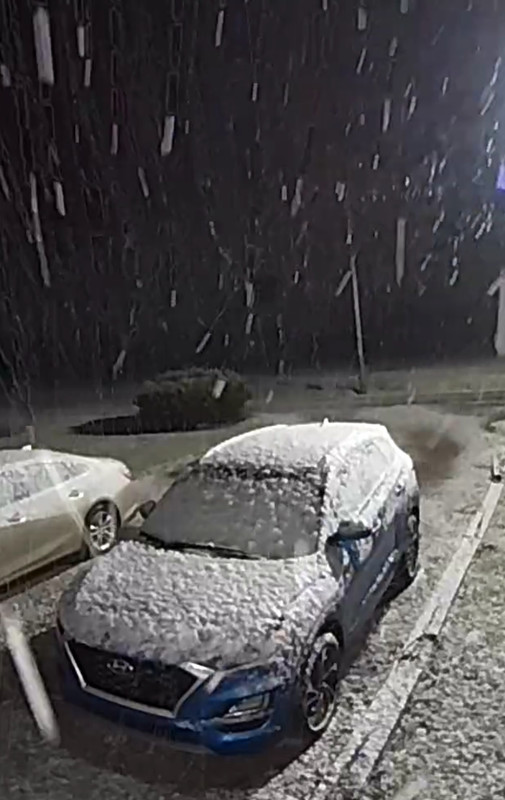
5 minutes ago, Save the itchy algae! said:
Maryville, right?
Yeah, it started about 30 mins ago and we quickly have got 1/2inch on grassy and elevated surfaces. Big ol flakes though.
-
2
-
-
Light rain in Maryville.
-
1
-
-
Complete white out conditions in Vonore. Roads covered with atleast 2 1/2in.
-
1
-
 1
1
-
-
1 minute ago, RawCrabMeat said:
Basically downtown
If I could attach pictures I would. Quickly got a inch. Don’t give up hope yet.
-
2
-
-
2 minutes ago, RawCrabMeat said:
Sorry if this belongs in banter but
anyone else get too emotionally attached to snow/getting burned by the models in a similar manner to UT football?
How far into Maryville are you?
Im 10 mins down the road and we just changed over 15 mins ago.
-
1
-
Historic Christmas Cold & maybe snow?! Dec 23rd-30th
in Tennessee Valley
Posted
0Z NAM seems to be following suite with the GFS.