

Scottie16
-
Posts
91 -
Joined
-
Last visited
Content Type
Profiles
Blogs
Forums
American Weather
Media Demo
Store
Gallery
Posts posted by Scottie16
-
-
1 minute ago, John1122 said:
I'd be very surprised but it's possible.
I’d bet there waiting to see how the system moved through Memphis before any updates are made.
-
 1
1
-
-
5 minutes ago, PowellVolz said:
Remember though… if the DGZ is close to the ground, the radar might not pick it up.
.Positive signs moving forward (for snow)
I pray that none of y’all or anyone loses power.
-
1
-
-
Seems like the radar is filling in?
-
2
-
-
-
-
Memphis.
-
3
-
 1
1
-
-
Be curious to see how fast the temperature drops for our friends our west. It looks like the front is about over Memphis.
-
1
-
-
3 minutes ago, John1122 said:
The ratios for the total event are generally coming in at 17:1 to 22:1 across areas NW of here. But many started out much colder. So we won't get there as an average for the event.
Wouldn’t the wind have a effect on the size of flakes?
-
1 minute ago, Silas Lang said:
Looks like the front is moving a tick faster on modeling. For example, the HRRR now has Knoxville below freezing at 12 instead of 1. I think that's been the trend everywhere?
I’ve saw anywhere between 10-12 from local media.
-
1
-
-
MRX update at 3 will be gold.
-
2
-
-
-
2 minutes ago, Scottie16 said:
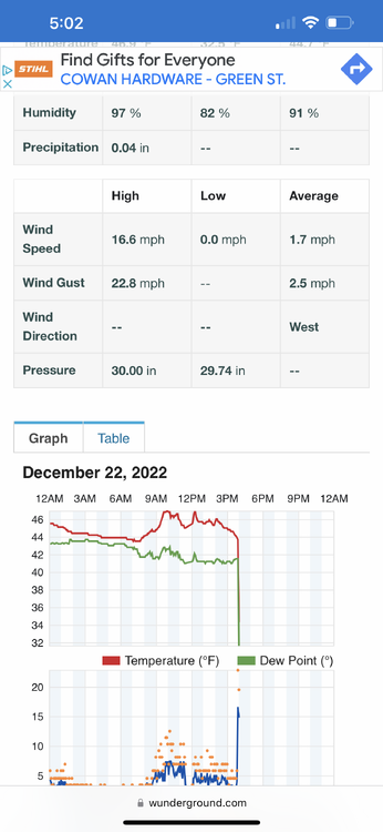
Looks to be .2-.3 for the eastern valley.
Rates forecasted to be at a minimum of 14:1. Snow map looks terrible. I believe there’s still so much uncertainty atm stil.
-
2
-
-
5 minutes ago, TellicoWx said:
Wouldn't be surprised SREF looked a tad better when I did a quick glance.
Looks to be .2-.3 for the eastern valley.
-
4
-
-
12 minutes ago, ShawnEastTN said:
Yeah I don't like most of the modeling trends this evening, but really think we are in for some surprises with this storm. I think the odds are higher for a surprise because historically surprises come in 2 flavors, very weak systems, and insanely over amped systems. Doesn't mean we'll get a surprise but a possibility. I think someone in the region is going to score well beyond what's modeled/forecast.
Sent from my SM-F721U using Tapatalk
So far. The nam is showing more QPF for the western part of the state.
-
1
-
-
5 minutes ago, fountainguy97 said:
Unfortunately ugly trends today for most. This arctic air mass sucks the life out of our moisture way too fast. It's a curse in disguise really.
Parent low too far north so we can't tap into any extra NW flow energy.
Not a non-event by any means! But this will be a pretty brief 1-2hr changeover to snow before the moisture dries up.


Looking at the flow west, the HRRR didn’t have that solution at all until the 18Z run. That’s a positive in the ugly trend.
-
3
-
-
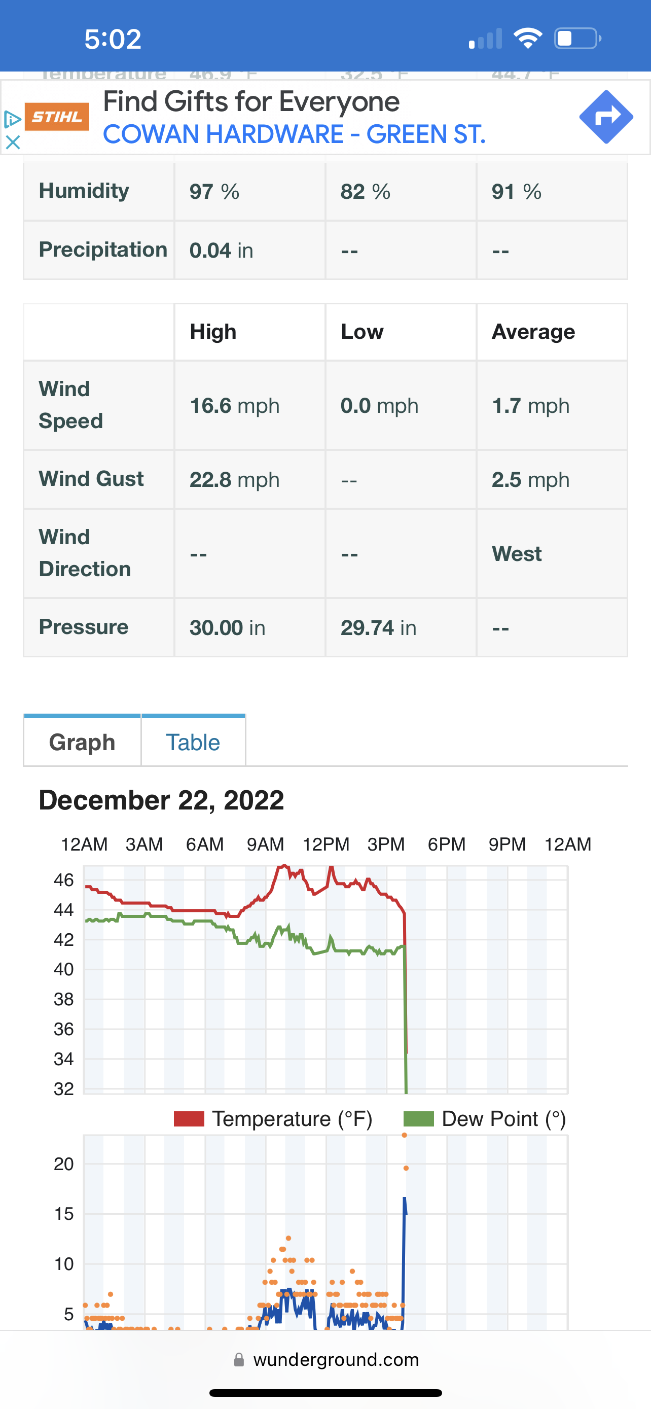
Also TX, I Think Colorado airport set the record for temperature drop in a hour. Going from 47• to 1•. I saw a couple of post that showed a 60 degrees change in feel like temperature..
-
2 minutes ago, TellicoWx said:
According to NWS Boulder, the interstate almost instantly froze over...most areas reporting 1"-2". If CODOT can't handle an inch or two, doesn't bode well for TDOT (assuming models are close to correct on plateau/west).
Im curious to see how MRX will adjust seeing how strong the front is now. The HRRR is at hour 22 and it finally shows the cold ahead of the front. Precip field seems to still hold.
-
2
-
-
Adding to what TellicoWX is posting
-
5
-
-
-
Euro has been trending southward every so slightly every run. HRRR has the low more south as well.
-
4
-
-
1 minute ago, TellicoWx said:2 minutes ago, TellicoWx said:

Albeit I hate that this cold could be disastrous for some, I’m excited to track it as it moves into the area; Mostly to see the battle of cold air rushing off the plateau into the Valley.
-
3
-
-
Just now, ShawnEastTN said:
What is interesting to me if snow amounts are more even a small amount more say 3" with the wind as strong as its going to be and the powdery nature of this type of snow, there could be times of serious visibility issues with near whiteout conditions from blowing snow. Would be amazing to see if we end up with more than currently forecast.
Sent from my SM-F721U using Tapatalk
You know the guys up in Morristown are stressing right now on issuing anything. If we had just a tad bit more moisture available we’d fall under blizzard criteria even with 2-3 inches.
-
7
-
-
Just now, John1122 said:
I think a lot of models are slowing the cold up as it hits the western Plateau, just enough for the moisture to race away from the front.
Seeing those temperatures drop in Montana brings hope that they won’t.
-
1
-
-


Historic Christmas Cold & maybe snow?! Dec 23rd-30th
in Tennessee Valley
Posted
Anyone else having breezy conditions in East Tennessee?