

AnthonyEC
-
Posts
70 -
Joined
-
Last visited
Content Type
Profiles
Blogs
Forums
American Weather
Media Demo
Store
Gallery
Posts posted by AnthonyEC
-
-
Still 47 here in Pikeville, KY. We had some rain earlier. But nothing now. Temps should start dropping around 2-3AM.
-
 2
2
-
-
1 hour ago, LakeNormanStormin said:
CAT 2 at landfall is my guestimate
Structure is solid
100 mph hurricane into Brevard county
I’m Not sure there is enough time to get there or enough latent heat.
-
12 minutes ago, Roger Smith said:
Current satellite image reminds me of an eagle attacking a school of tuna, all that's needed is a bun and some mayo.
Anyone else getting the sense that Nicole may not really make a landfall in FL but may just graze the east coast of the state and move towards coastal GA?
http://www.weather.gc.ca/data/satellite/goes_eusa_1070_100.jpg
No chance. High pressure way too strong
-
 1
1
-
-
Overnight and morning models picking up strength with each run. Treasure Coast coming into play quickly.
-
1
-
-
18Z GFS not giving up yet

-
4 hours ago, Whineminster said:
If all that got dealt a Major blow is FMB and Sanibel I'd consider this a win, you don't hear a ton about catastrophic damage in FM itself or Cape Coral
2 feet of flood waters in a house isn’t as photo worthy for the media
-
4
-
-
6 minutes ago, CoastalWx said:
This thing is virtually a coastal storm.
Large nor’easter
-
1
-
-
Gotta improvise sometimes

-
 5
5
-
-
4 minutes ago, jm1220 said:
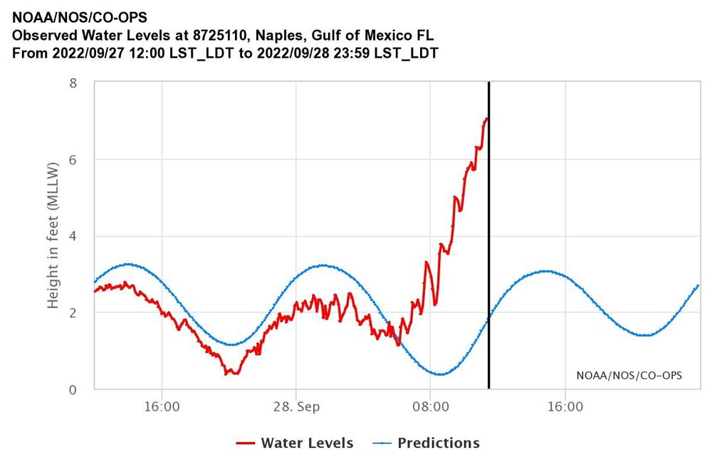
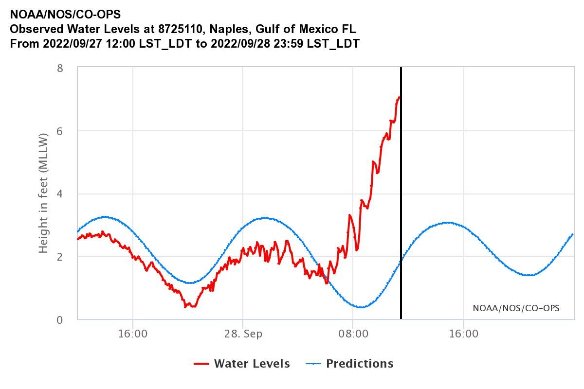
And water still rising in Ft Myers. Up to 8.57ft.
Think the gauge is broken. Quit updating
-
Just now, Mowfishin said:
Fort myers gauge up to 8.33
What’s the link?
-
1 minute ago, mob1 said:
Jumped back up to over 6' after falling to about 4.5' a few minutes ago.
Could be a gauge malfunction.
the one in Naples stopped reporting about 1PM today.
-
1
-
-
8 minutes ago, mob1 said:
Now dropping like a rock
And right back up.
-
Just now, dan11295 said:
kind of a pick your poison, a bit better for Charlotte Harbor, but worse for Fort Myers.
Worse for Ft Myers south also. Bonita Springs, Naples, Marco, Pelican Bay.
-
1
-
-
1 minute ago, MANDA said:
Someone else feel free to chime in but considering the intensity, size, surge prone coast being affected, major population area, high end real estate and rainfall associated flooding could this be the costliest CONUS hurricane of all time by the time ALL is said and done? Katrina stands out in front of the pack but have to believe this will make it into the top 5. Any thoughts?
Katrina, Sandy, Harvey in that order. This may fall as #4.
-
1
-
-
Naples at 7 feet now
-
1
-
-
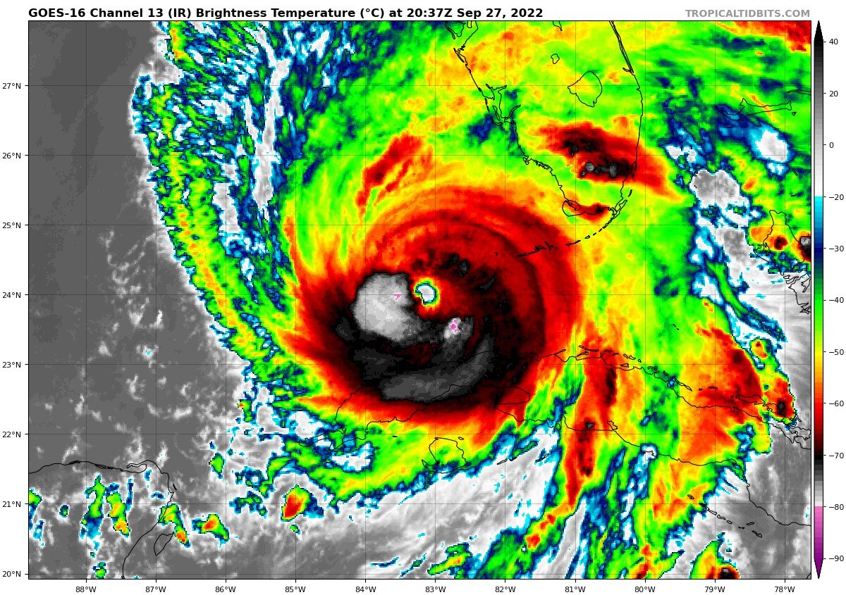
20 minutes ago, Nibor said:

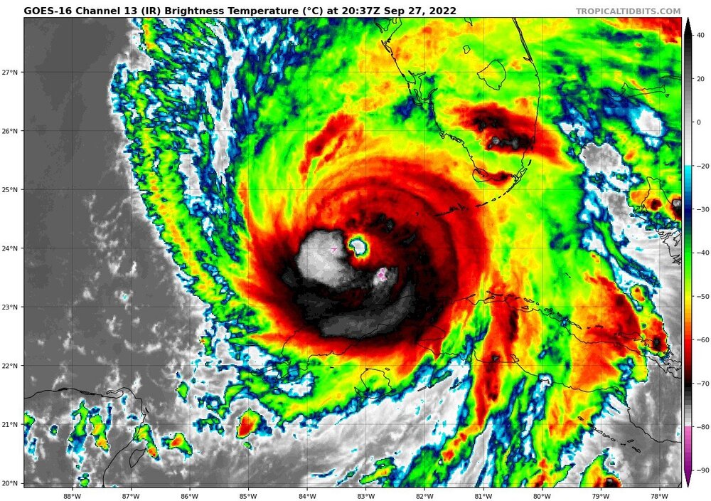
Eye looks clear. Cold cloud tops popping up in the SE quadrant.
Maybe a 2nd ERC?
-
2 minutes ago, Nibor said:

I'm not sure why there are comments on the radar appearance. Looks to me like Ian is about to close off its eye again and the band heading north east looks formidable.
Is it just me or is it heading just west of north? It has been a long day and I may be seeing things.
may be just directly north over the entire radar presentation.
-
1
-
-
2 minutes ago, GaWx said:
Ian appears to have been moving steadily N instead of NNE recently. If so, was this expected?
Wasn’t out of the realm of possibility especially given the 0Z GFS. Landfall looks closer to Manasota Key now than Punta Gorda.
-
1
-
-
Just now, NorthHillsWx said:
Is anyone else not gawking over the radar/satellite presentation tonight? I know it’s a strong storm but it’s SW side is nowhere near as symmetrical as earlier, it has a ragged eye (remnants of ERC), and it looks like a dry slot is developing east of the core. Satellite is starting to show outflow being restricted to the west and some asymmetrical shape to the CDO. IMO, Ian has peaked. I don’t see why a 5kt increase would g be possible if the eye fully closes but I’m seeing a system that looks past prime this hour
Eyeball replacement cycle occurred and you are worried about 5 knots when the storm surge just rose 2-4 feet in Marco Island?
The IKE has increased and will continue to do so until landfall. I don’t think 7MPH means much now.
-
2
-
1
-
1
-
-
2 minutes ago, 1234snow said:
18z HWRF completes the ERC soon, develops a big eye, and bombs Ian down to 928mb. I really hope that intensity is off. HMON is a more “reasonable” 939mb
HWRF and HMON always seem to overdo pressure drops.
-
1
-
-
1 hour ago, Hotair said:
Here’s something new to consider
The 18z NAM was very intriguing. Shows Ian coming off of Florida at 993 mb and deepening to 971 mb before making another landfall in SC. The same thing shearing it may provide a pattern for re-intensification, and there is enough warmth in the Gulf Stream. Something to watch.This has been shows in several models the last few days including the ICON, UKMET and JMA.
-
1
-
-
3 minutes ago, StormChaser4Life said:
I'm skeptical on their 130mph landfall in FL. Not sure Ian will be able to achieve this with this EWRC that may take a while and if that opens up the core or makes it unstable it could subject it more the the shear that's beginning to impact it. Hard to say.
The EWRC while slowing the max winds will increase the surge potential dramatically by expanding the hurricane force wind field.
-
Maybe hot towers starting to set up an EWRC.
-
 6
6
-
-
2 minutes ago, Hotair said:
Are any of the models running now accounting for the latest intensity recon is finding at this hour? Ian looks stronger now than NHC had forecast at 11 am. Those of you who study gulf canes, is it a sound assumption that higher intensity will resist eastward steering more resulting in a more Northward track for longer vs a weaker storm?
Didn’t happen with Charley.
This is already feeling the trough.
-
1
-

Historic Christmas Cold & maybe snow?! Dec 23rd-30th
in Tennessee Valley
Posted
Really picking up now. I can hear it outside. Rain blowing in sideways like Forrest Gump.