

Ed, snow and hurricane fan
-
Posts
1,618 -
Joined
-
Last visited
Content Type
Profiles
Blogs
Forums
American Weather
Media Demo
Store
Gallery
Posts posted by Ed, snow and hurricane fan
-
-
Euro relatively dry with DFW, ratios would still support ballpark 5 inches. Big Cities, I-35 Waco to San Marcos look like the winners. DFW may just be too far North for the big action. 12km NAM should be getting in range, looking at NYC subforum, NAM is having a good Winter up there and is even drier for DFW. GFS and Euro have a decent discrepancy on the amount of QPF in Houston Sunday night/Monday morning, almost half an inch. NAM splitting the difference.
-
31 minutes ago, aggiegeog said:
I just got my email from Ambit regarding the need to cut back on electrical use.
Direct Energy said we should properly insult our pipes. OT, verbatim GFS Wednesday starts with freezing rain in Houston before a quick change to rain, by the time heavy rain arrives it would near 40F, but 5 days out, maybe it turns out to be more than just a hundredth between changeover. skew-Ts in Winter, didn't think I'd do that much.
-
Ratios will be worse, but QPF better per GFS on mid-week system. Temps at the saturated level by Wednesday evening may not support efficient dendrite formation, could cause 'snizzle. 5 days out, but potentially even more interesting than Sunday, even if Sunday has better ratios just because of temps.
I wonder how many buildings in DFW built for a total 1.5 or higher liquid equivalent snow weight on their roofs. I remember, after we moved to Texas, a supermarket roof collapsing back in Massapequa because of a couple of consecutive heavy snows. 8 lbs/square foot, a 1.5 inch liquid equivalent snowpack...

-
I don't know how it helps, but per Direct Energy's precautions, I told my pipes they are stupid.

-
 5
5
-
-
EWX-
This is an
unprecedented week of weather for South-Central Texas. Our collective
group of meteorologists at our offices can not remember a time where
we had 4 potential winter weather events across our County Warning
Area in one week.
-
 2
2
-
-
Dallas would like the GFS better for the two storms, assuming one likes snow.
Houston would like the Euro better for QPF down here, mid week storm Euro is, literally, one degree Celsius too warm for the famous once a decade Houston big highway cloverleaf ramps skating party. Not a lot of QPF mid-week, but a touch colder, just a dab'll do ya. I think, looking at Euro and GFS, Houston has very little freezing rain Monday, a change from rain to sleet and graupel. Wondering if some snow flakes might survive the slight warm nose. Sleet or snow, once you have half an inch, the pictures look very similar.

-
Born in NYC, raised on Long Island, Grandma now buried in Marshfield, but lived across from North Quincy T, saw as many Yankee games at Fenway, maybe more, than Yankee Stadium (my late Dad didn't like going to the Bronx) In Texas 40 years...
Former NY-er and former unpopular poster. Blizzard of 1978 my favorite storm. (5 days no school St. Martin of Tours, Amityville, NY) Any red taggers want to visit Texas thread for a once every two decade Winter event and give expert opinion?
-
Former NY-er and former unpopular poster. Blizzard of 1978 my favorite storm. Any red taggers want to visit Texas thread for a once every two decade Winter event and give expert opinion.
-
I took my document camera home. My school district doesn't observe Presidents' Day but is giving teachers and students tomorrow off. It is hard to teach math w/o a document camera and I can see my school insisting on a remote day Monday. We were told to bring our computers and materials home.
-
Houston AFD mentions possibility of not being able to travel from late Sunday into Tuesday. Looking at models, hard to tell if it will be rain, and for how long. 850 mb temps drop pretty quickly Monday morning, so I suspect a rain to sleet to snow event. QPF varies, Euro is over 3/4 inches. GFS a little less, both close on surface temps at the start around 6Z Monday
Dallas people will hate 18Z QPF. But ratios should be great.
-
40 minutes ago, Chinook said:
Weather-related disaster in Fort Worth. You guys have probably already heard this on the news if you are from this area.

5 dead at least. The truck drivers who piled in looked like they were going the speed limit. This was well forecast by FWD, I suspect the highway information signs had messages about driving on ice. And people were still driving the speed limit.
-
Euro 850s are barely above freezing, I no longer have a good PPV model page since WeatherBell jacked my rates, I'd love to see Monday skew-Ts to see how much of the forecast 0.8 inches is sleet or freezing rain in Houston. Half an inch liquid DFW, all snow and 850 mb below -10°C and well below freezing surface, that should fluff well over 10:1.
-
GFS suggests there is more coming after Monday
-
Canadian posting is weenie. But my urban school district doesn't celebrate Presidents' Day, and I want the day off near Houston.

-
GFS and Euro, off and on between runs, sleet or freezing rain Monday late or Tuesday early in Houston. Late Monday/Tuesday could be a day off school...

-
10 minutes ago, shadowsintherain said:
I remember Jebwalks! Ahhhh. The good old days.
.Mid Atlantic forum poster, IIRC, during intense snowstorms he took walks to experience them up close and personal. Name was 'Jeb', obviously.
-
2
-
-
2 hours ago, CIK62 said:
Starting to look more like a rain event. My High T yesterday was 51* and I currently (2pm) have 45*. (46* at 3pm.) All I am seeing are T's in the mid 30's for the whole event. Remember one week ago this was a rain event with the primary low hundreds of miles up into Canada, just dragging a front with it.
https://www.nws.noaa.gov/cgi-bin/lamp/getlav.pl?sta=KNYC&sta=KJFK&sta=KLGA
12Z Cobb Method outputs: GFS 1" NAM 6", mixing issues
Even the linked model data shows very low initial dewpoints and evaporative cooling when precip starts
-
1
-
-
11 hours ago, LibertyBell said:
Storm Field died? wth, what happened?
I think he is alive. He was about 30 when I moved.
-
1 hour ago, Mitchel Volk said:
Sad about Tex he was drunk and said after a news story about a rape “just lay back and enjoy the”.
Dr. Frank Field was an eye doctor, not a met doctor, but the Army did send him for a degree in met during WW2.
I was in his backyard in Nassau Shores, mid 1970s, he had a pit bull which tried to copulate with my leg. Storm Field should still be alive...
-
1
-
 1
1
-
-
IIRC, my favorite storm of all time, 5 days no school, February 1978, was technically a Miller B, but, again, from memory, it was enhanced by mid level energy that pushed an Arctic front through NYC area as the coastal was developing off the Carolinas. I moved from Massapequa 2 years later. Now big storms are nostalgia.
-
4 minutes ago, omo_yankee said:
when do the winds come in
LGA 31G41 ISP 23G38
-
2 minutes ago, chrisNJ said:
I moved to NJ from GA in 2004. I’ve become complacent already. I use to be ecstatic with flurries.
Moved Massapequa, NY 11758 to Dallas just after the Blizzard of 1978. Dallas at least gets a dusting almost every Winter, Houston, last snow was a dusting in 2017.
One thing, one doesn't know what a real severe thunderstorm is living on Long Island. -
I am now bracketed between snow reports at DWH and IAH, but all I can feel is sleet, not even 'slow raindrops' which might be a not quite completely melted snowflake clumps.
-
Can't tell in the streetlights if there is any snow, but I can hear and feel on my car roof some sleet, maybe 10 miles SE DWH and 5 miles West of IAH. At 30.00001N, 29.9999N is a 15 second walk from my front door.


Texas Winter 2021
in Central/Western States
Posted
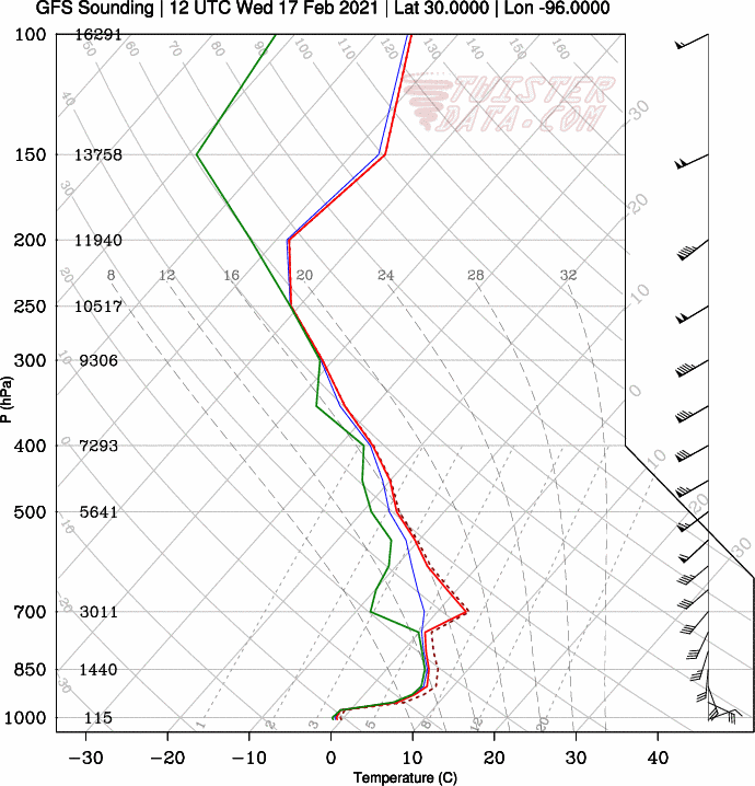
Looking at soundings on Euro, 850s and College Station support snow, QPF suggests more than drizzle, but temps are not cold enough in the saturated layer for dendrites, could be serious icing. Similar in Houston, except 850 temps don't quite support snow.