Moderately Unstable
-
Posts
324 -
Joined
-
Last visited
Content Type
Profiles
Blogs
Forums
American Weather
Media Demo
Store
Gallery
Everything posted by Moderately Unstable
-
In short, windspeeds are much higher, and the wind curvature is higher. It's like a mesovort in a multi vortex tornado. Same cyclostrophic balance equation, same enhancement of momentum. Definitely can be risky to fly through particularly at low speeds. Aircraft have a lower turbulence speed than clear air speed. That's (part of) why they slow down as they approach the storms. However, slow speed increases the risk of stalling. Wind shear is a rapid change in wind speed and direction. At low speeds, that places the plane at risk of stalling. You don't want to stall in an eyewall. There are other issues, basically, a meso in an eyewall is like flying through a tornado both in terms of size and what it does to the plane. It can down the plane, even without a stall.
-
So you can see from the plot that they flew a circle. Each of those wind barbs is a data point. They weren't embedded in the circulation, they flew a circle inside the eye. They basically found an opening and took it.
-
That is quite possible actually, perhaps likely.
-
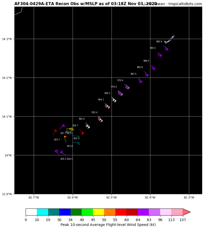
New VDM. Mesovortices. Would like to see the radar loop if they can put it up on twitter after the mission. 302 URNT12 KNHC 030403 VORTEX DATA MESSAGE AL292020 A. 03/03:10:10Z B. 14.03 deg N 082.61 deg W C. 700 mb 2435 m D. 925 mb E. 290 deg 14 kt F. CLOSED G. C7 H. 135 kt I. 127 deg 3 nm 03:07:00Z J. 232 deg 127 kt K. 135 deg 4 nm 03:06:30Z L. 125 kt M. 043 deg 5 nm 03:13:30Z N. 135 deg 125 kt O. 043 deg 5 nm 03:13:30Z P. 11 C / 3037 m Q. 20 C / 2998 m R. 3 C / NA S. 12345 / 07 T. 0.02 / 0.5 nm U. AF304 0429A ETA OB 15 MAX FL WIND 137 KT 193 / 5 NM 02:18:00Z MANY MESOVORTICES ROTATING ON INSIDE EYEWALL. ;
-
Yes, it is out of the question. ERCs occur when a ring of very strong thunderstorms encircles a pinwheel eye. This new ring contracts and as it does so it robs--literally takes--the angular momentum from the inner eye and expands it out. Angular momentum is conserved, but a larger radius of winds lowers the wind speed and raises the pressure. After the cycle completes, the new eyewall can contract and potentially re-strengthen. It takes several hours to occur, and is first visible on radar (ground or plane--the plane has radar which is how they characterize a "closed" versus "open" eye), so if there's one in progress you'll see it there before you see it on satellite.
-
Hm. So lowest extrap there was 922.1 and they made a loop followed by a 90 degree right turn to sample that side. Does look like a possible second eyewall from the data.
-
Lol. Bro, I haven't looked at the original forecasts yet at all--I'm not saying I expect a cat 5 because of MY forecast, I'm saying it because THE NHC said it would. I don't care whether I win, good work, excellent job. But I haven't looked through yet to verify everything. Busy looking at the data.
-
That pressure looked a bit lower.
-
Just gonna post up the discussion: ZCZC MIATCDAT4 ALL TTAA00 KNHC DDHHMM Hurricane Eta Discussion Number 10 NWS National Hurricane Center Miami FL AL292020 1000 PM EST Mon Nov 02 2020 An Air Force Reserve reconnaissance aircraft has found that Eta has explosively deepened into a strong category 4 hurricane with maximum sustained winds of 130 kt and a minimum central pressure of 927 mb. Eta has maintained a small 10-nmi-wide eye that is evident in satellite imagery and on the San Andreas, Colombia, weather radar. The radar data also suggest that concentric eyewalls may be forming, which would be an indication of the onset of an eyewall replacement cycle (ERC) and a capping of Eta's intensity and also an end to the rapid intensification cycle of the past 36 hours. The initial intensity of 130 kt kt is based on 700-mb flight-level winds of 137 kt and SFMR surface winds of 130 kt. Some additional strengthening is expected, and Eta could become a category 5 hurricane before landfall occurs. After landfall, Eta should quickly weaken while it moves over the mountainous terrain of Central America. Eta has slowed and is now moving southwestward or 245/06 kt. There is no significant change to previous track forecast reasoning. A mid-level ridge over the south-central United States should steer Eta west-southwestward toward the coast of Nicaragua with the hurricane making landfall early Tuesday. After landfall, Eta should turn westward and then west-northwestward, and move across Central America through Thursday. Eta's low-level circulation may not survive its passage over the mountainous terrain of Central America, but most of the global models continue to depict a cyclone or its remnants moving over the northwestern Caribbean Sea by late-week and into the weekend. Therefore, the new NHC track forecast continues to show the system emerging over the northwestern Caribbean late in the period, although this portion of the track forecast remains uncertain. Since Eta is likely to be a very slow-moving system after it makes landfall in Central America, torrential rains and flooding will be a major threat. Key Messages: 1. Catastrophic wind damage is expected where Eta's eyewall moves onshore along the northeastern coast of Nicaragua tonight or early Tuesday. Tropical storm force winds are beginning to reach the coast within the Hurricane Warning area in Nicaragua, and residents there should have completed their preparations. A Tropical Storm Warning is also in effect for the northeastern coast of Honduras. 2. A catastrophic and life-threatening storm surge, along with destructive waves, are expected along portions of the northeastern coast of Nicaragua near and to the north of where the center makes landfall. Water levels could reach as high as 14 to 21 feet above normal tide levels in some parts of the hurricane warning area. Preparations to protect life and property should now be complete. 3. Through Friday evening, heavy rainfall from Eta will likely lead to catastrophic, life-threatening flash flooding and river flooding across portions of Central America, along with landslides in areas of higher terrain. Flash and river flooding is also possible across Jamaica, southeast Mexico, El Salvador, southern Haiti, and the Cayman Islands. FORECAST POSITIONS AND MAX WINDS INIT 03/0300Z 14.1N 82.7W 130 KT 150 MPH 12H 03/1200Z 13.9N 83.3W 140 KT 160 MPH 24H 04/0000Z 13.9N 84.0W 90 KT 105 MPH...INLAND 36H 04/1200Z 13.9N 85.0W 45 KT 50 MPH...INLAND 48H 05/0000Z 14.3N 86.3W 30 KT 35 MPH...INLAND 60H 05/1200Z 14.8N 87.8W 25 KT 30 MPH...POST-TROP/REMNT LOW 72H 06/0000Z 15.4N 88.7W 30 KT 35 MPH...POST-TROP/REMNT LOW 96H 07/0000Z 16.8N 87.9W 30 KT 35 MPH...POST-TROP/REMNT LOW 120H 08/0000Z 17.9N 85.3W 40 KT 45 MPH $$ Forecaster Stewart NNNN
-
Welp. They went 150mph and 927mb. They do call for it to become a cat 5 before landfall.
-
I'd put it at a low cat 5. I think if they don't go cat 5, they'll probably say, they expect it to become a cat 5. Then again I also said 917 and revised to 912 and 150kts, so I'm not trustworthy right now. Oof.
-
Correction. 928mb. Vortex Data Message: 691 URNT12 KNHC 030242 VORTEX DATA MESSAGE AL292020 A. 03/02:16:00Z B. 14.10 deg N 082.55 deg W C. 700 mb 2469 m D. 928 mb E. 090 deg 17 kt F. CLOSED G. C6 H. 124 kt I. 346 deg 3 nm 02:15:00Z J. 076 deg 123 kt K. 352 deg 5 nm 02:14:30Z L. 130 kt M. 190 deg 4 nm 02:17:30Z N. 280 deg 137 kt O. 193 deg 5 nm 02:18:00Z P. 10 C / 3051 m Q. 21 C / 2995 m R. -4 C / NA S. 12345 / 07 T. 0.02 / 0.5 nm U. AF304 0429A ETA OB 07 MAX FL WIND 137 KT 193 / 5 NM 02:18:00Z ;
-
It feels like the entire site is on this thread. 116 members are currently viewing this. How many guests? 1000? I sure am glad to have something else to focus on right now to, ya know, what's going on right now. Theteam reported a north eyewall minimum pressure of 929mb. This likely means the central pressure is 923-925mb.
-
Well then. Interesting. I would like to see all 4 sides of the eyewall sampled before I make a wind comment. I also want to see what the pressure tendency is. VDM will be helpful. This is, in fact, why you fly the recon. I wouldn't count out a minimal 5. They only need 140kts surface to get that. It's close. It's just not a high end 5. The fact they didn't find wilma 2.0 isn't the most surprising thing, given that that's the record holder. It will still likely be a 5. Just isn't apparently Goni.
-
If they did a timelapse they could show lightning. If they have a low light camera, which, they might, you could see a lot.
-
This is very exciting I have to say. I hope they post a video on their twitter page of the punch through. I know it's dark but perhaps they can still see something.
-
My hands are going to fall off. This is more enthusiasm than the actual season prediction got. No. This is an algorithm thing. Earlier for example it was capped at 0.7T/6hrs. Other times there are no constraints. CIMSS varies what rules they use based on a slew of decision trees (computer calculated).
-
Entries now closed. Final predictions: LongBeachSurfFreak: 920mb/145kt The Ghost of Leroy: 920mb X --> 900/160kts jpeters3: 895mb Moderately Unstable: 917mb/145kt X--> 913/150kts sojitodd: 914-917mb Snowlover22: 890mb/155kt X--> revised: 170-175kts Newman: 910mb/150kt olafminesaw: 913mb/150kt X --> revised: 897mb/160kts Master of Disaster: 921mb/140kt Doc Jon: 888mb/155kt Will-Rutgers 925mb/140kt OhioWX: 923mb/145kt DDweatherman: 917mb/145kt yotaman: 915mb/145-150kt Floydbuster: 922mb/140kt BYG Jacob: 913mb/145kt X --> 895mb/160kts That Hurricane: 904mb/160kt CatLover014: 919mb/145kt Orangeburgwx: 919mb/140-145kt tiger_deF: 890mb/160kts Normandy: 883mb/160kts WxWatcher007: 912mb/148kts X revised: 903mb/155kts Hawkeye_wx: 916mb/140kts NorthArlington101: 907mb/150kts SRRTA22: 908mb/150kts USCAPEWEATHER: 896mb/165kts X --> 885mb/175kts Amped: 895mb/160kts pdm44: 901mb/155kts Prospero: 911mb/160kts BuffaloWeather: 906mb/140kts Stebo: 915mb/145kts OKTWISTER: 932mb/140kts Wild Weather Monger: 901mb/160kts Louieloy102: 903mb/150kts LakeEffectKing: 899mb/150kts wxmx: 885mb/165kts Jim Marusak: 935mb/140kts. hlcater: 901mb/150kts Calderon: 902mb/155kts OSUmetstud: 890mb/155kts NavarreDon: 903mb/155kts jojo762: 887mb/155kts BlueDXer: 899mb/165kts Calculation of consensus: Mean: 905.85mb/ 152.7kts
-
Well, I was going to calculate.a consensus average from everyone's entries for the pressures and winds, but since so many entries have come in I'm still trying to organize everyone and will calculate shortly. ENTRIES WILL CLOSE AT THE NEXT DATA UPDATE (~1:52UTC).
-
ESTIMATED PRESSURE/WIND CONTEST--SO FAR: Note: Entries and edits close once the aircraft enters the storm. LongBeachSurfFreak: 920mb/145kt The Ghost of Leroy: 920mb X --> 900/160kts jpeters3: 895mb Moderately Unstable: 917mb/145kt X--> 913/150kts sojitodd: 914-917mb Snowlover22: 890mb/155kt X--> revised: 170-175kts Newman: 910mb/150kt olafminesaw: 913mb/150kt X --> revised: 897mb/160kts Master of Disaster: 921mb/140kt Doc Jon: 888mb/155kt Will-Rutgers 925mb/140kt OhioWX: 923mb/145kt DDweatherman: 917mb/145kt yotaman: 915mb/145-150kt Floydbuster: 922mb/140kt BYG Jacob: 913mb/145kt That Hurricane: 904mb/160kt CatLover014: 919mb/145kt Orangeburgwx: 919mb/140-145kt tiger_deF: 890mb/160kts Normandy: 883mb/160kts WxWatcher007: 912mb/148kts X revised: 903mb/155kts Hawkeye_wx: 916mb/140kts NorthArlington101: 907mb/150kts SRRTA22: 908mb/150kts USCAPEWEATHER: 896mb/165kts X --> 885mb/175kts Amped: 895mb/160kts pdm44: 901mb/155kts Prospero: 911mb/160kts BuffaloWeather: 906mb/140kts Stebo: 915mb/145kts OKTWISTER: 932mb/140kts Wild Weather Monger: 901mb/160kts Louieloy102: 903mb/150kts LakeEffectKing: 899mb/150kts wxmx: 885mb/165kts Jim Marusak: 935mb/140kts. hlcater: 901mb/150kts Calderon: 902mb/155kts OSUmetstud: 890mb/155kts NavarreDon: 903mb/155kts jojo762: 887mb/155kts If I haven't listed you yet or haven't updated your value, please standby. Y'all are enthusiastic.
-
(1) Entries are allowed until the aircraft is "in storm": within the storm's circulation. Assuming this radius to be 150mi, at a speed of 240knots, they have around a half hour. (2) Should I allow guess updates (yes or no)?
-
Yes. 10-30 mins before entries close folks. They're closing in on the outer circ.
-
ESTIMATED PRESSURE/WIND CONTEST--SO FAR: Note: Entries and edits close once the aircraft enters the storm. LongBeachSurfFreak: 920mb/145kt The Ghost of Leroy: 920mb jpeters3: 895mb Moderately Unstable: 917mb/145kt sojitodd: 914-917mb Snowlover22: 890mb/155kt Newman: 910mb/150kt olafminesaw: 913mb/150kt Master of Disaster: 921mb/140kt Doc Jon: 888mb/155kt Will-Rutgers 925mb/140kt OhioWX: 923mb/145kt DDweatherman: 917mb/145kt yotaman: 915mb/145-150kt Floydbuster: 922mb/140kt BYG Jacob: 913mb/145kt That Hurricane: 904mb/160kt CatLover014: 919mb/145kt Orangeburgwx: 919mb/140-145kt tiger_deF: 890mb/160kts Normandy: 883mb/160kts Note: I will be offline the next half hour to hour, will update again when I return.
-
ESTIMATED PRESSURE/WIND CONTEST--SO FAR: Note: Entries and edits close once the aircraft enters the storm. LongBeachSurfFreak: 920mb/145kt The Ghost of Leroy: 920mb jpeters3: 895mb Moderately Unstable: 917mb/145kt sojitodd: 914-917mb Snowlover22: 890mb/155kt Newman: 910mb/150kt olafminesaw: 913mb/150kt Master of Disaster: 921mb/140kt Doc Jon: 888mb/155kt Will-Rutgers 925mb/140kt OhioWX: 923mb/145kt DDweatherman: 917mb/145kt yotaman: 915mb/145-150kt
-
I'm going with 917, 145 knots. Edit: Upped from 140 to 145 on speed based on pressure. I feel like 140 is more likely but I'm going to go ahead and swing high.