
WhirlingWx
-
Posts
404 -
Joined
-
Last visited
Content Type
Profiles
Blogs
Forums
American Weather
Media Demo
Store
Gallery
Posts posted by WhirlingWx
-
-
What is it with those SW TX storms that always seem to do their own thing in May? If I recall correctly, there were some instances of it last May and I'm sure in some years past as well. Currently a storm east of Fort Stockton which is SVR warned with TOR possible mentioned
-
They had the area of greatest concern for large hail just now upgraded to an ENH risk within the SVR T-storm Watch... Interesting.
-
4 minutes ago, BrandonC_TX said:
Those storms are definitely outflow-dominant now. The outflow boundary has surged well ahead of the storms, and is currently over central Dallas County and southern Tarrant County (and is just north of the KFWS radar site). If these storms had maintained unimpeded inflow at or near the surface we would probably be having a major hailstorm over DFW right now, but fortunately that outflow surged out ahead of the storms.
Yeah it shows now and the storm is below severe levels as it tracks southeast
-
2 hours ago, BrandonC_TX said:
Interestingly enough there might be some outflow out ahead of this storm, from west of Thackerville over to Muenster and Bowie (which is evident on the KFWS radar). Might be a sign of a possible weakening trend, but this does not appear ahead of the lead storm over Thackerville.
Welp. I was thinking the storm would go south through Denton and Tarrant counties but it's taken an interesting turn to the east and looks like it'll hit here in southern Collin County... warned for 65 mph winds and ping pong ball sized hail.
-
Aaaand now we have one TOR warned storm... in South Carolina
-
1 minute ago, Snowstorm920 said:
Wicked hook developing on that cell near Miami OK
@jojo762 was near there as of last time he posted, I wonder if he stayed in the vicinity.
-
This is from the outlook regarding the area of focus for a tornado threat
...OK/KS/MO/AR/TX this afternoon and evening...
   Latest surface analysis shows a low over northwest OK with the
   dryline extending southward into western north TX.  This dryline
   will surge eastward today as a cold front sags across KS into OK.
   Current indications are that the triple-point of the cold front and
   dryline will be over far northeast OK by late afternoon.  There is
   also a subtle warm front extending from northeast OK into central
   AR.  This boundary will lift slowly northward as well.  The result
   will be a zone of low-level convergence and rapid thunderstorm
   development in the 3-5pm period over extreme southeast KS, northeast
   OK, and southwest MO.  These storms will be in an environment of
   very high CAPE values, steep mid-level lapse rates, and ample
   deep-layer shear to support supercell structures.  Low-level shear
   profiles will also be very strong - especially in vicinity of the
   warm front where backed surface winds will enhance 1km helicity
   values over 500 m2/s2.  Storms that form will pose a risk of very
   large hail and a few tornadoes (including strong tornadoes).  The
   primary negative factor for tornado risk is the linear forcing
   mechanism along the cold front, which may result in undercutting and
   a transition to linear storm structures within a couple of hours of
   initiation.  This activity will likely spread east-southeastward
   across northern AR after dark with a hail/wind and isolated tornado
   risk.

   Farther south along the dryline and cold front, storms should
   develop through the late afternoon and evening across the eastern
   half of OK and perhaps into north TX.  Very large hail is the
   primary risk with these storms.
Mentions the somewhat quick transition to a linear mode being a possible limiting factor to the tornado threat, which might have been discussed here(?), ingredients look impressive though.
-
3 minutes ago, yoda said:
1 mile south of Plano per SWS
Yep, heard that and then another saying 2 miles north of Richardson so I assumed those were the same one. Both had 78 mph. Weird to hear two different relative locations but since they share a border I don't know what else is between there
-
78 mph wind gust between Plano and Richardson, according to a prelimimary storm report
-
 1
1
-
-
Lots of lightning, wind starting to howl and rain is picking up.
-
Yep, hearing rumbles of thunder now. Looks like a sort of line has congealed from Denton County down to Fort Worth, 2 severe warnings cover the line. Winds for the northern warning up to 70 mph possibly, large hail mentioned as well.
-
Northern Little Rock metro looks to get hit by a strong part of the squall with a TOR warning there and definitely strong winds
-
With the storms moving towards the Metroplex being more discrete, there is likely an increased threat for hail from them. As for tornadoes, currently meh (which is good news). Latest MD states that the best threat for a tornado or two is NE TX/SE OK/SW AR
-
Denton, TX currently in the path of a severe thunderstorm, with other SVR warned storms to the west and southwest, out of the cells that have crossed the Red River
-
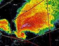
1 minute ago, Buckeye05 said:
That's actually a fairly intense couplet near Clayton, OK. Wouldn't be surprised if that put down a substantial tornado.
It certainly stuck out to me as well as the strongest out of the three in that image.
-
2 minutes ago, Chinook said:
Three possible tornadoes in southeast Oklahoma

Those signatures came up pretty quickly, but moving east so they'll likely be taken over by the line soon?
-
8 minutes ago, BrandonC_TX said:
90%/70% severe wind probabilities on that new severe thunderstorm watch, high odds but not enough for PDS. If those odds were slightly higher (let's say >95/80) then I think they would have gone PDS.
Yeah, does PDS for severe t-storm watches have a different criteria than TOR watches (with regard to probabilities)? I want to say yes but I can't remember for sure
-
8 minutes ago, rnj79 said:
We have gotten hammered with rain here in SELA!! It looks to have caught all of the Mets by surprise.
Looks like SELA has the only tornado report of the day so far as well
-
 1
1
-
-
Watch coming soon including DFW area
Mesoscale Discussion 0494
   NWS Storm Prediction Center Norman OK
   0806 PM CDT Tue Apr 28 2020

   Areas affected...north central through northeast Texas into
   southwest Arkansas and northwest Louisiana

   Concerning...Severe potential...Watch likely

   Valid 290106Z - 290200Z

   Probability of Watch Issuance...95 percent

   SUMMARY...Severe storms with a threat for mainly damaging wind and
   large hail are expected to develop southeast into north-central and
   northeast Texas, southwest AR and northwest LA this evening into
   tonight. A WW will likely be issued prior to 0130Z.

   DISCUSSION...Severe storms continue developing along a
   southeast-advancing cold front from eastern through south-central
   OK. The downstream warm sector across north-central and northeast TX
   is very unstable with the 00Z RAOB from Fort Worth indicating 3500
   J/kg MLCAPE and 9 C/km 700-500 mb lapse rates along with 35-40 kt
   effective bulk shear. An inversion was evident near 800 mb at the
   base of an EML, and convective inhibition will increase as the
   surface layer cools. However, deep forcing and convergence along the
   southeast-advancing cold front should remain sufficient for
   additional thunderstorm development this evening into tonight. Both
   multicell line segments and some embedded supercell structures will
   be possible with large to very large hail and widespread damaging
   wind gusts the main threats, though a tornado or two cannot be ruled
   out.
-
MD on the segment of the bowing segment impacting Springfield, MO says 60-80 mph wind gusts possible as it moves east
-
2 minutes ago, cheese007 said:
Definitely getting similar vibes to the June wind storm from last year in DFW. Took out a ton of trees and knocked a crane onto an apartment buildin
Ah yeah I remember, did we have a couple tornadoes with that one? We actually had a few storm systems and tornadoes in June. My family and cousins got the bright idea to go to a community swimming pool that day, storm took everyone by surprise and the leading edge of the line was ominous and rotating in front of me. We got some gusts of 60+ mph there.
-
4 minutes ago, BrandonC_TX said:
I wonder what the odds of getting a tornado are for north-central Texas if there happen to be discrete storms around? I know the supercell composite, helicity, and significant tornado values often do go up in the evening and at night (RAP on SPC Mesoanalysis shows this happening over north-central TX prior to the arrival of storms), but that storms often become more elevated at night as well. The HRRR model also has the DFW area at the tail-end of the line of storms.
It always concerns me to see forecast values that high over a highly-populated area (DFW) with what could be some semi-discrete activity, but I have seen this happen before in the late spring and summer with few-to-no tornado reports. This is also a northwest-flow scenario and there tend to be fewer tornadoes with that. That said, I do wonder if we will see a derecho this evening.Yeah, I've been wondering about that too. Being on the western/southwestern edge of the line (most likely) got me wondering if we could see a broken line of cells impacting our area rather than the squall, but I still think that with this being a northwest-flow scenario (as you said), and really not much shear in the area, I'm not very concerned about anything more than maybe a few weak tornadoes (then again, there's a lot of built-up areas here and it'll be late at night), but trends will continue to be monitored. The threat may very well increase, it's just not looking that way to me as of now. If DFW ends up getting in on a derecho, that'll probably result in a lot of power outages and damage in its own right.
-
Tulsa metro has been under the gun, with Springfield, MO next- I'd expect there to be more activity in this thread!
-
Now a TOR warning in N OK and another in Louisiana in a separate storm complex.
Central/Western Medium-Long Range Discussion
in Central/Western States
Posted
Could end Kansas' tornado drought this year if we do get some action there