

BucksCO_PA
-
Posts
2,136 -
Joined
-
Last visited
Content Type
Profiles
Blogs
Forums
American Weather
Media Demo
Store
Gallery
Posts posted by BucksCO_PA
-
-
11 hours ago, uncle W said:
1988-89 snowstorms in this area ...
12/13-14/1988.....10.4" Islip LI...
1/6/1989.................5.0"...Central Park...
2/24/1989.............12.3" Atlantic City...
3/6/1989.................5.0" Brooklyn...
Serious gradient with that FEB 1989 storm, 12.3" at the AC airport in Pomona which is 8-9 miles inland from the city. The city itself recorded 19", nearby Somers Point had 18" & down the road portions of coastal Cape May County had up to 24". Most likely true blizzard conditions along the immediate coast. Another 15 miles inland from the AC airport Hammonton recorded less than an inch.
Setup for that storm was very cold airmass that set records from MI down to FL. FEB 1989 is the snowiest month on record for Norfolk & Wallops Island, VA.
Hard to analog much from the 80's as we're light years away from that background state. Looking back at OCT 1988 that was the 7th coldest OCT on record for the NE region
-
 1
1
-
-
3 hours ago, wdrag said:
Long ways to go... and to me it looks nasty at times for LI/NJ coast into Tuesday morning. Think the topic with it's 628AM Sunday commented adjustments is valid.
It took a while for the measurable rain to make it to I80 north (midnightish).
My only significant adjustment is that it's apparent that the heavier bands occurring this morning may ease to drizzle for a time this afternoon with renewed bands of heavier showers/rain redeveloping northward late today and especially overnight-early Tuesday. The strongest east wind for this entire system may not occur til around 2AM-7AM Tuesday when gusts 45 or possibly 50 MPH should occur near coastal LI. 2+" of rain not impossible for NYC by the time 2PM Tuesday rolls around, and thinking isolated 4.5" still within the realm of possibility either tiny portion of the NJ coast (Ocean.Monmouth) or possibly LI.
So far, over 1" has occurred in a portion of coastal Ocean County NJ, and many locations 1/4-3/4" in NJ. Winds are gusting to ~ 30 MPH much of the NJ coast.
OKX radar storm total looks reasonable to me.
Follow local NWS statements on tidal flooding at the time of high tide.
Mount Pocono 41 degrees at 10:00am with a wind chill of 33
-
 1
1
-
-
3 hours ago, cleetussnow said:
I said it in another thread...I am still digging out from last years euro seasonal winter forecasts, so not sure how much weight to give them at this point. For my purposes the look overall isn’t wretched for my winter quarters in the Adirondacks. I worry more about big melts that kill the pack than storm shut outs months. Nothing sucked worse than last January so I’ll take my chances.
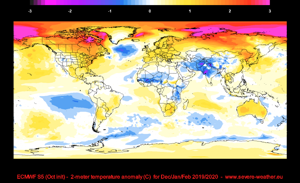
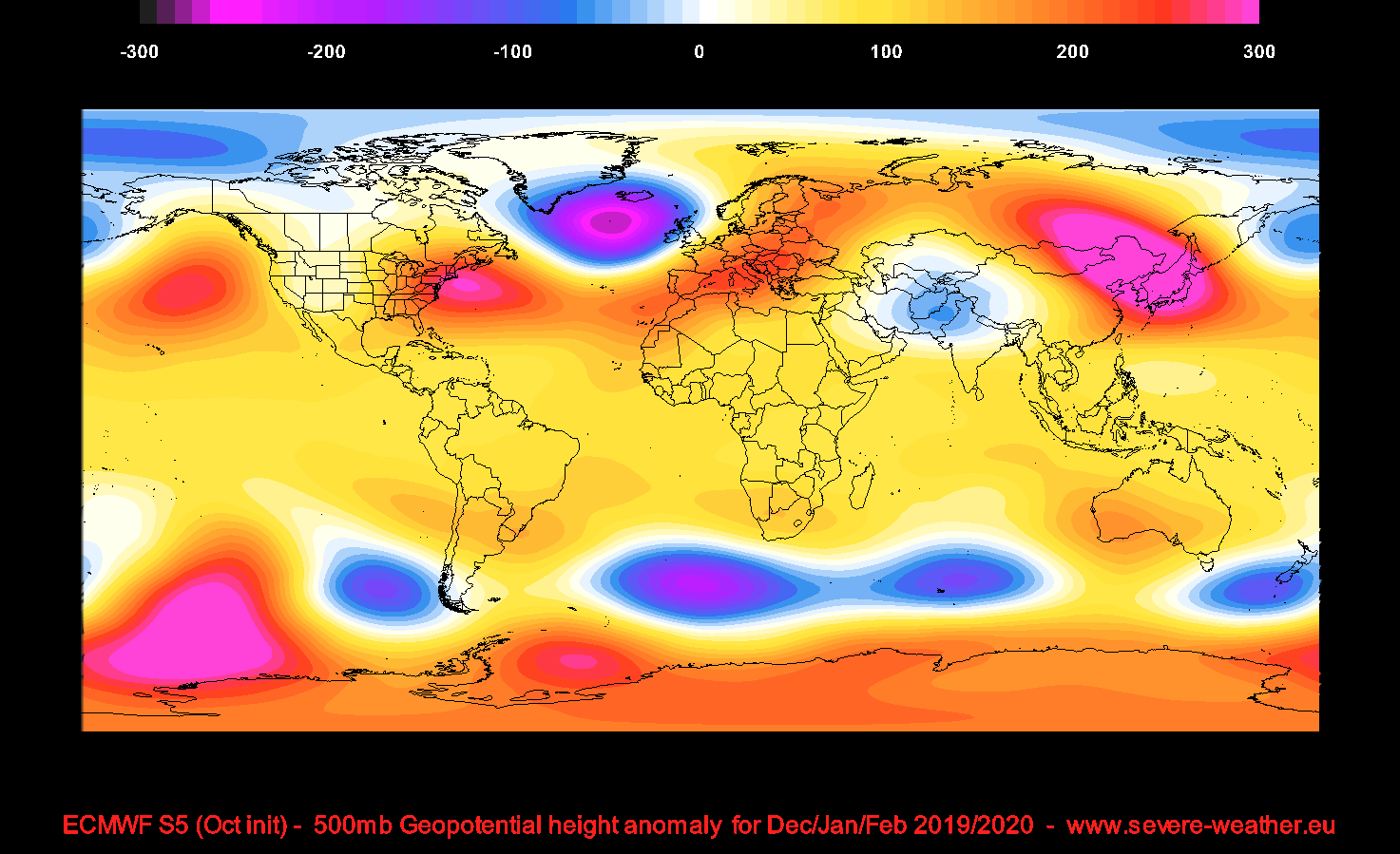
I've seen this thrown out there on several forums regarding last years euro winter forecast, am I missing something because this forecast from last OCT looks pretty solid. Now the weeklies are a completely different story as they've blown chucks over the past 2 winters.
https://www.severe-weather.eu/long-range-2/winter-2019-2020-ecmwf-forecast-october-fa/

-
1
-
-
3 hours ago, SnowGoose69 said:
The problem continues to be who knows where the SSW impacts. Remember there have been disastrous SSWs before where they impact Alaska or the western US and we go into a full blown torch. December 1990 and February 1989 I believe we’re both examples of SSWs that did this. Sometimes having it impact Europe or Siberia isn’t the worst thing for us because the entire polar region setup is disrupted hemisphere wide so we can still benefit here. Of course January 2012 is an example of one that impacted Europe and did nothing here at all
Feb 1989 was a tremendous month for the immediate MA coastline, snowiest month on record at Norfolk & Wallops Island. Richmond also got in on the action with a top 5 Feb. The storm on the 24th that month was a true blizzard for coastal SNJ with amounts close to 2' in Cape May County.
-
1
-
-
Props to DT 6-10" call worked out
The "adjusted" last call in itself is a joke but to top it off he lowered snow amounts in DE, S Jersey despite the fact he ripped "TV" Mets for lowering snow totals in DE & S. Jersey less than 6hrs. earlier.
This winter season hasn't been one of DT's finer moments.
-
DT just issued his 1st guess
1" line - just south of DC to Georgetown, DE
4" line - just north of Baltimore to Townsend, DE to Brigantine, NJ
8" line - Gettysburg, PA to Center City Philly to Pt. Pleasant, NJ
12" - Eastern Poconos through Central CT north of NYC
-
on the food chain EPAWA & Steve D. would be below plant life, there's no possible way one could claim these two provide any kind of value
-
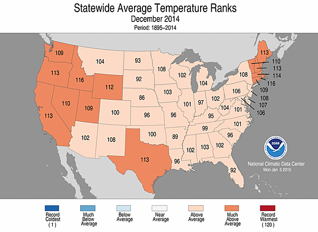
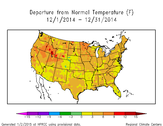
For the lower 48 DEC 2014 was the 2nd warmest DEC on record, records go back to 1895
Lots of similarities between this past DEC & DEC 1976

http://www.ncdc.noaa.gov/sotc/national/2014/12
-
not so swell....but he did keep saying he was being stubborn - which as we all know is his bias. Still overall on pattern recognition he has been top notch this year with the exception of the delayed but not denied December cold
December cold
 it was wall to wall warmth, serious reality check
-
this is pure entertainment, I mean I almost fell off my chair:
https://twitter.com/BigJoeBastardi/status/551923979913805824
then you have the other guy in Richmond ranting & raving about the 4" this morning in DC in the face of the official 1-2" forecast however when you look at his map you see 1-2" for Balt., DC, & immediate burbs
can't make this stuff up
-
thanks bucks I missed the 15th had it as 89 instead of 90. Updated the totals
NP - Last time TTN hit 90 was 7/23, needless to say that changes this afternoon as all I needed to do was walk out the door at 5:30, like hitting a wall....
PHL is flirting with a record high minimum this morning, have to see if any of the in between hourly ops got below 76
-
Newark: 92, TEB: 92, New Brunswick: 90
PHL/ACY: 89
Newark: 92, TEB: 92, New Brunswick: 90
PHL/ACY: 89
TTN has 9 days for the year, correction is 7 for July
-
So... what's JB think for this summer?
The greatest threat for a landfalling hurricane along the U.S. coastline will be between Eastport, ME & Brownsville, TX

October 2020 General Discussions & Observations Thread
in New York City Metro
Posted
yep, had sun filtering thru clouds all day while the shore was getting rocked
& to punish us even further just 10 days later we were under a warning for 6-10" however the storm crapped out after 2-3", whole complexion of that winter would have changed if we'd hit on those 2 setups
as for today, 0.04" in my bucket this morning, saw a healthy 0.41" report from Sea Girt on the CNJ coast