

BucksCO_PA
-
Posts
2,136 -
Joined
-
Last visited
Content Type
Profiles
Blogs
Forums
American Weather
Media Demo
Store
Gallery
Posts posted by BucksCO_PA
-
-
2 hours ago, forkyfork said:
*that area of central park
LGA had the same AUG max as Central Park, so much for the tree canopy
-
 1
1
-
 1
1
-
-
56 minutes ago, WX-PA said:
GFS and Euro backed off from their 100 degree reading for next week. Mid 90's seems reasonable which makes sense for September
This is thanks to Tony at PhillyWX for tracking, thru 8/24 individual runs of the GFS have forecast 100(+) degree highs at PHL on 57 occasions. Note - obviously multiple runs with 100(+) degree forecasts for same day
Breakdown of those forecasts:
100 degrees - 21 days
101 degrees - 15 days
102 degrees - 9 days
103 degrees - 1 day
104 degrees - 5 days
105 degrees - 3 days
106 degrees - 2 days
110 degrees - 1 day
 the actual high for the day of this beauty was 84 degrees
The average actual highs at PHL for all these triple digit forecast days was 83-84 degrees.
One bright spot for the GFS's pending 23 days for 100(+) degree September forecast is at least those days should have an actual average temp in the 90's.
-
 2
2
-
-
17 minutes ago, WX-PA said:
I mean the high for Chicago on September 11th the first day of NFL football in 108 degrees on the GFS..Really that is hard to believe for September.
Dallas & the Eagles played opening day, 9/3/2000, in 109 degree weather at Texas Stadium. This is the hottest game in NFL history. Sad part for Dallas they had to play the next week in 100 degree weather at Tempe, AZ. They lost both games.
-
38 minutes ago, WX-PA said:
How many times has it reached 100 in NYC in September?..Has there ever been a heat wavein September with 7 days in a row with temps above 90?...I doubt that has ever happened
NYC & Philadelphia both recorded 100 degree days during SEPT 1881 & 1953. NYC had (1) 100 degree day in each of those 2 years while Philadelphia had (2) in 1953 & (1) in 1881.
For both locations the SEPT max temp record is 102 degrees.
-
3 minutes ago, forkyfork said:
what happened to one day of 90?
yes one day around 90 & 4 days in the mid 90's
Canadian has long duration heat wave for SEPT now approaching triple digits around PHL, GFS would temper things later next week with an onshore flow from what's left of Idalia.
torch SEPT followed by a cooler than average OCT
-
1
-
-
I believe the PHL SEPT record for 90 degree days is 8, very good chance we're halfway there by next Thursday. Even the GEM is toasty next week so looks like there's no ducking this shot. At least this is Sept & not the middle of July.
-
27 minutes ago, Stormlover74 said:
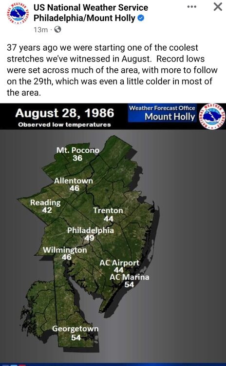
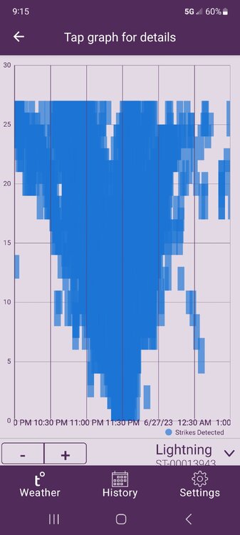
PHL recorded 3 consecutive record lows on 8/28-30, 49, 44 & 47 degrees. 44 degrees is the record monthly low for AUG.
Mount Pocono dropped to 31 degrees on 8/30 & Bradford checked in with a balmy 25 degrees on 8/29 - LOL, friggin 25 degrees in AUG
Conversely PHL has not recorded an AUG low in the 50's since 2013.
-
6 minutes ago, lee59 said:
Newark will hit 90.
& the sun rises in the east....
-
3
-
1
-
 2
2
-
-
13 hours ago, Allsnow said:
Philly still hasn’t hit 90 for the month of August
PHL reached 91 degrees on the 15th. Outside of the usual suspects that run out of tolerance warm many locations north & east of Philly haven't reached 90 so far this month.
I wouldn't discount FRI especially for Philly south & west, they are still in the game for 90 degrees.
-
11 hours ago, forkyfork said:
i think most people in a band from cnj through nyc and li get 2-4"
would have been a great forecast for SE Wisconsin, what's 800 miles among weenies
-
2 hours ago, nycwinter said:
why you keep posting this gfs garbage you know these temps will never happen.
Individual runs of the GFS have forecast 100+ at PHL at least 25 times this summer, highest temp so far has been 95 degrees. This is just thru 8/11 & doesn't even reflect the recent onslaught of 100 degree forecasts for future dates.
You can upgrade that model all you want but it's still embarrassing.
-
5
-
-
13 minutes ago, nycwinter said:
counting down the end of summer..the end of summer for me starts sept 1..
Since 2010 Sept has been much more summer like as opposed to the traditional start of fall. Recently Sept has been great month to hit the S. Jersey beaches, ocean water in the 70's & plenty of days in the 80's even late in the month.
My personal clock doesn't hit fall until OCT 1st.
-
4
-
-
just another day at the office....
Public Information Statement
National Weather Service Mount Holly NJ
903 AM EDT Tue Aug 8 2023
...Preliminary Storm Surveys Scheduled for multiple locations...
The National Weather Service office in Mount Holly NJ will
conduct storm surveys today for the following locations:
Chadds Ford and Glen Mills in Delaware County Pennsylvania
Hockessin and Newark in New Castle County Delaware
Afton Village and Midway Manor areas in Lehigh County Pennsylvania
Milford in Hunterdon County New Jersey
The survey is in relation to the severe thunderstorms that moved
through the area on August 8 2023.
A final assessment including results of the survey are expected
to be completed and transmitted via a Public Information
Statement by This Evening.
The storm survey information will also be available on our
website at http://www.weather.gov/phi
-
51 degrees at ABE this morning, 2nd coldest for the date (49 degrees - 1947)
-
36 degrees in Saranac Lake, NY this morning. Coldest for the date since the record low of 34 in 1959.
-
1
-
-
3 hours ago, bluewave said:
6 days reaching a 100° last summer at Newark and Freehold and SMQ at 5. There were 2 COOP sites that made it to 100° in PA. The Franklin Institute in Philly reached 100° back in 2021. A COOP in PA had 6 days reach 100° in 2020. So Philly hasn’t been a local warm spot as the airports have been a little cooler with the flow off the Delaware River.
Data for January 1, 2022 through December 31, 2022
Click column heading to sort ascending, click again to sort descending.NameStation TypeNumber of Days Max Temperature >= 100NEWARK LIBERTY INTL AP WBAN 6 Newark Area ThreadEx 6 FREEHOLD-MARLBORO COOP 6 SOMERSET AIRPORT WBAN 5 CANOE BROOK COOP 4 HARRISON COOP 4 SOUTH JERSEY REGIONAL AIRPORT WBAN 3 LONG BRANCH-OAKHURST COOP 2 HIGHTSTOWN 2 W COOP 2 New Brunswick Area ThreadEx 1 MANASQUAN 1 NW COOP 1 NEW BRUNSWICK 3 SE COOP 1
Data for January 1, 2022 through December 31, 2022
Click column heading to sort ascending, click again to sort descending.NameStation TypeNumber of Days Max Temperature >= 100NORRISTOWN COOP 1 ACMETONIA LOCK 3 COOP 1
Data for January 1, 2021 through December 31, 2021
Click column heading to sort ascending, click again to sort descending.NameStation TypeNumber of Days Max Temperature >= 100SHIPPENSBURG COOP 2 WOLFSBURG COOP 1 ACMETONIA LOCK 3 COOP 1 PHILADELPHIA FRANKLIN INSTITUTE COOP 1 Philadelphia Center City Area ThreadEx 1
Data for January 1, 2020 through December 31, 2020
Click column heading to sort ascending, click again to sort descending.NameStation TypeNumber of Days Max Temperature >= 100MURRYSVILLE 2 SW COOP 6 HARRISBURG CAPITAL CITY AP WBAN 3 MIDDLETOWN HARRISBURG INT'L AP WBAN 1 WILLIAMSPORT REGIONAL AP WBAN 1 Williamsport Area ThreadEx 1 Middletown-Harrisburg Area ThreadEx 1 LOL, torch wind at PHL is a west wind which isn't a flow off the Delaware. Wilmington is several miles off the river which is SE of the airport so again torch winds there aren't coming off the river. For Trenton the river is a fraction of the size & has no affect on the ASOS a mile or two away & over 150' up hill. There's reason why these top line ASOS stations haven't reached 100 degrees in 11 yrs. It's because they're consistent, reliable & represent their surrounding area's very well. Newark represents a patch of rock hard ground immediately adjacent to miles of black runway asphalt & 12 lanes of nonstop traffic. Other locations like Mt. Holly are consistently out of tolerance warm.
Even bigger LOL is you referencing Murrysville in conjunction will Philly, that location is a suburb of Pittsburgh. Most likely another garbage station since Pittsburgh hasn't recorded 100 degrees since 1995. Harrisburg & Williamsport are also locations nowhere near PHL.
-
1
-
1
-
-
Looking at Philadelphia quite a stark contrast to the recent trends at this point in the year.
- At PHL this will be the coolest June since 1985, depending on the high today will finish at 70.6 or 70.7 degrees.
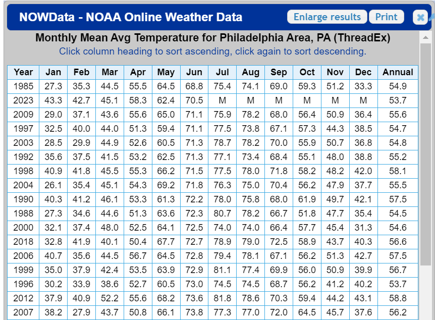
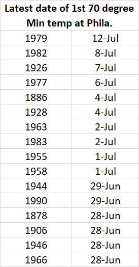
- PHL has yet to record a 70 degree minimum at this point in the year. Over the entire 150yr POR the average date of the 1st 70 degree minimum is 6/10. Since 2000 that average date moves forward considerably to 5/30. It's a top 10 latest date on record at this point & likely the latest since 1983.
- It also appears likely that PHL will finish June with only (1) 90 degree day this year. Regardless if for some reason today hits 90 that will still represent the fewest 90 degree days at this point in the year since 1982. Below are a listing of the 27 years with 0-2 90 degree days thru June.
- The record low max of 66 degrees on 6/21 was the 1st June record low of any kind at PHL since the record low max of 67 degrees on 6/21/1999.
-
2
-
3 hours ago, SACRUS said:
1980 - The temperature at Wichita Falls, TX, soared to 117 degrees, their hottest reading of record. Daily highs were 110 degrees or above between the 24th of June and the 3rd of July. (The Weather Channel)
1980 was another year in which Texas was baking to start the summer. For 21 of the 30 days from 6/19 thru 7/18 the record highs at Dallas are from 1980. The stretch included 11 consecutive days from 6/23 thru 7/3 with record highs.
Looking back at 1980 locally June was similar to this year temp wise. As the summer progressed July turned very warm compared to the averages at that time & Aug was a dry torch by any standard. It's the warmest AUG on record at Central Park & #3 for Philly.
-
1
-
-
Corridor from N. Delaware to NE Philly has now recorded 9-12" for the month. Officially Wilmington (11.91") will at least finish with the 3rd wettest June on record.
Locally 4.81" since FRI
6.47" for the month
-
2
-
1
-
-
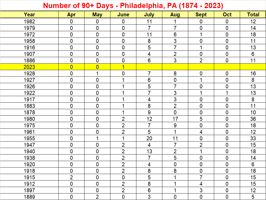
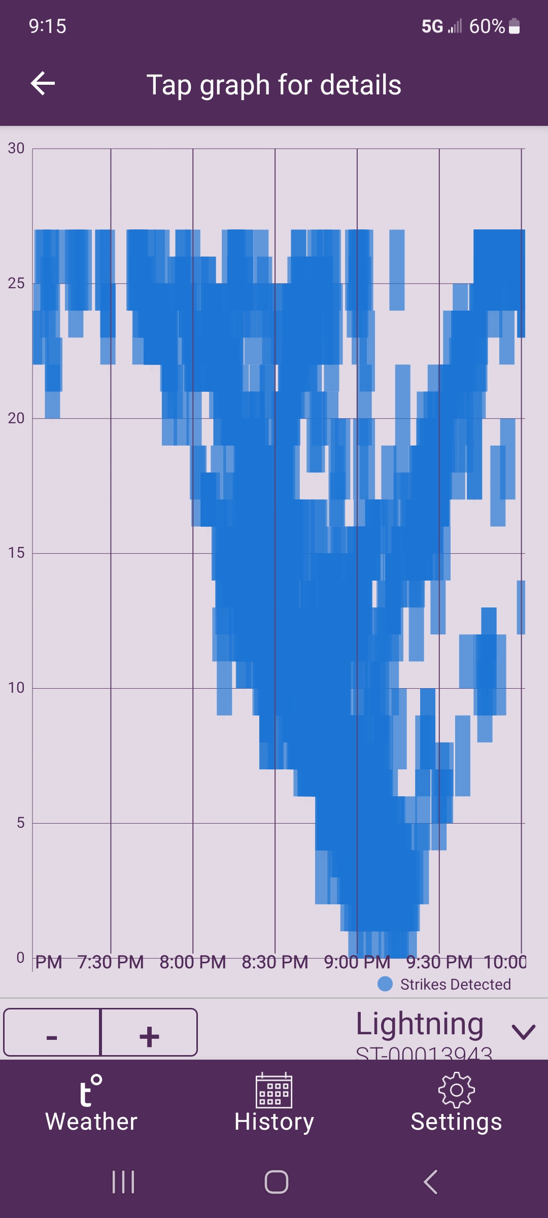
Tempest recorded 11,315 lightning strikes yesterday & this morning.
Non stop lightning with the 2 warned cells last evening.
2.12" yesterday & this morning, 5.46" for the month
-
2
-
-
15 hours ago, bluewave said:
It’s actually the coolest June in Philly since 2009 and 3rd overall coolest since 2000.
Time Series Summary for Philadelphia Area, PA (ThreadEx)
Click column heading to sort ascending, click again to sort descending.RankEnding DateMean Avg Temperature Jun 1 to Jun 22Missing Count1 2003-06-22 68.0 0 2 2009-06-22 69.2 0 3 2023-06-22 69.3 0 4 2004-06-22 71.2 0 5 2000-06-22 71.4 0 The ranking thru 6/22 is irrelevant to my point. How PHL ends the month is what was actually addressed.
PHL is currently 69.2 degree for the month, projecting out the remainder of the month based on the current forecast PHL would end up at 70.6 degrees. If so that would represent the coolest June since 1985.
It's not out of the question PHL ends up with the coolest June since 1985 -
27 minutes ago, Wxoutlooksblog said:
Again, temperatures are going to warm for the July 2nd-5th time-frame. I think it will be just be a question of how much of the rain and associated clouds with all these disturbances moving across the country affects us as to whether or not we can get into the upper 80s to lower 90s during this time frame. If we can dry out for a couple of days, maybe the 4th/5th, we could have a shot at 90. If clouds and rain persists, we will not have a shot at 90...maybe low-mid 80s.
WX/PT
By that timeframe average highs across Philly / NYC metro areas are in the mid to uppers 80's so low 90's are nothing to write home about. It then becomes can we avoid the 95+ crap.
Regardless of whether July & August end up following the recent torch trends this has been fantastic 2nd half of spring & segue into early summer. It's not out of the question PHL ends up with the coolest June since 1985
-
2
-
1
-
-
18 hours ago, zenmsav6810 said:
I seem to remember a few summers where we were 10"-15" behinf in July and August. September 2006 was pretty dry too.
Assuming you mean 10"-15" in the hole for the year? Philadelphia precip records go back to 1872 & there're only 3 yrs. in which there was a double digit deficit thru Aug:
1995 (-12.85")
1992 (-11.08")
1964 (-10.39")
Note - based on the current precip averages which overall are the wettest on record, actual monthly averages were lower for those years compared to the current figures.
Sept 2005 was the 2nd driest Sept on record, Sept 2006 was solidly wetter than average.
-
1
-
-
Only in the Philly forum could an historic smoke outbreak enveloping the region segue into a discussion about old dive bars & strip joints.
-
2
-
September 2023
in New York City Metro
Posted
88 degrees is also the lowest AUG max temp at Central Park since 1963