

MarkO
-
Posts
3,337 -
Joined
-
Last visited
Content Type
Profiles
Blogs
Forums
American Weather
Media Demo
Store
Gallery
Posts posted by MarkO
-
-
HIt 99.7ºF here in Lowell yesterday. Can't remember if I've ever recorded 100. My overnight low was 77.5. Today's forcast high is 103.
-
15 hours ago, Brewbeer said:
this. did this 8 years ago, haven't paid an electric bill in 8 years, currently have a $1k credit with Eversource and it is peak generating season and the ACs still aren't installed yet

I've also noticed the solar panels keep my roof cooler, so it's a win/win. I'm only at $295 credit on my latest bill, but that will probably increase by a few more hundred come September.
-
 1
1
-
-
16 hours ago, mreaves said:
Did you have an electrician wire a line for it?
I used the existing wire from my former electric hot water tank. It happened to be the exact gauge I needed. Wiring isn't very difficult. You can youtube just about anything.
-
On 5/14/2025 at 5:45 AM, BrianW said:
Yeah. They are outstanding units that behave like a mini split. We have some of the most expensive electricty in the US in New England. Anyone not running one of these is just throwing money to Eversource.
I don't think people realize how expensive electricty in New England is compared to the US.
Top 5 most expensive according to the EIA monthly data..
Hawaii .4269
Connecticut .3325
RI .3307
California .3166
MA .3044
https://www.eia.gov/electricity/monthly/epm_table_grapher.php?t=epmt_5_6_a
A traditional window AC unit just cycles the compressor on and off at full speed at like 800 watts. They usually end up running non-stop at like 800 watts when that much cooling power is often not necessary.
These Midea U are using variable speed dc fans and compressor. They can throttle the compressor down to as low as like 150 watts and run up to max at the exact cooling load for the room. They are also like 10 times quieter at low speed. I
100%! I got so fed up with my monthly bill ageraging $230, I gave in, cut some trees and went with solar. If you do go with solar, buy it outright, and oversize it. It will take 6 years to pay for itself. I have a 7 pitch rear roof (30º) that's 10 degrees west of due south, so almost ideal, but I still have neighbors trees that affect my production, especially in October.
Since my installation, my meter has been on the positive side of 0 for a few months, but I'm currently at 99,335, and I'm at $295 in credit according to my last bill. If I can accurately calculate how much to use for heat, I shouldn't have another electric bill for as long as I live here.
-
3
-
-
On 5/11/2025 at 9:29 PM, bristolri_wx said:
I need to pick up some window air conditioners this season. Unhappy with a GE unit I purchased last year. What brands/models are folks having success with that last more than two or three seasons? As much as I like to do things to help the environment, these high efficiency window units don't last like the units from the "good ole days". And before you ask - can't afford mini-splits... yet...
Installing AC units is a PITA. Have you thought about a mini-split? I installed one for heat because my solar panels are overproducing, but it is so much better than window units and wasn't too difficult to install. I went with a Mr. Cool.
-
1
-
-
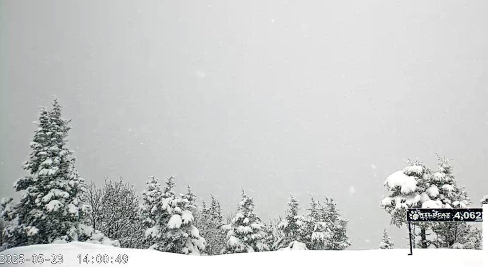
The summit of Wildcat probably has over 6"
-
5
-
-
Silly New England weather. 6" and still snowing at cabin, 33F and drizzle in Lowell, but mid 80's in SW CT.
Edit: light snow in Lowell 32.9F
-
1
-
-
Mere 1/2" in Lowell, so that puts it at about an inch OTG. Might just barely meet the White Christmas theshold if it remains cloudy today. The cabin does much better with these clipper events. About 4.5" new from this event and it looks like there's about 8-10" of a snow pack with 2" of white cement on the bottom.
-
It flipped a couple hours ago, looks like 2" new on the deck.
-
1
-
-
Supposedly Steamboat had their largest avalanche over Thanksgiving weekend, and it's dumping now. Time to wake the boys and get their asses out of bed.
-
Just went for a ride. About 2" on valley floor, close to 4" here at 1100', nad about 6" at 1500'
-
1
-
-
It's dumping pancakes. It's been snow all day, but nothing to show for it. About 3" of dense wet pack OTG. If you're wondering, yeah, blew off both Thanksgiving dinners nad came up last night. Hopefully you all understand bc nobody else seems to.
-
1
-
 3
3
-
-
Speaking of ski areas, was planning to ski Watervillle, but got word they were only going to have two lifts open up top and downloading on the 6-seat Tecumseh Express. I told one of the employees if they end up with a foot of snow, you can expect skiers to be ducking ropes and skiing to the bottom.
-
1
-
-
Gene and I typically have similar conditions and seasonal totals. But there are times when I'm getting rain, and he's still dumping snow and vice versa. I believe our elevations are pretty similar.
-
3
-
-
32 minutes ago, NW_of_GYX said:
What happens if her foot is bigger than yours
Figuratively, her's is! She just told me "I'm Air B&B'ing a condo in Florida in January with my sisters". I told her "Awesome, have a good time, I'll pop in for a long weekend, and oh, yeah, I just booked a week at Steamboat with Bryan." She asked me which boyfriend Brian, or Bryan?, I told her the pilot one, lol.
It's just how our relationship has worked over the years. She's always been very close with her sisters, as I am with my friends. The kids are grown/independent (college junior, highschool senior). We've learned things like holidays and Thanksgiving aren't worth fighting over. We used to fight over it, but now that we've been married for 22 years, it's actually much better.
-
3
-
1
-
-
32 minutes ago, CoastalWx said:
That makes more sense then. Are you far from Sandwich Notch road?
Only about a mile as the crow flies, but it's about a 5 minute drive to the beginning on 49.
-
Just now, CoastalWx said:
Good luck with staying married.
When it comes to skiing and snowstorms, she know's better, lol. It's the reason I built the cabin in the first place. Plus, she's on call, so she's heading back from RI after dinner.
-
2
-
-
Screw people. I just changed plans from dinner in RI (wife's side dinner aroun 6pm) to Danvers (my side 1pm) and going to bail out of there by 2, and spend the evening up north with just my dog and a roaring wood stove
-
7
-
 1
1
-
-
Hmm,well the American models just made things interesting with their latest run with an 990 mb low in the GOM. Might have to make some changes to the Thanksgiving Day travels.
-
 1
1
-
-
The CMC and Reggie are consistent with the potential for 4-8" in the mountains, at least enough to cover the ground and make for some travel headaches.
-
1
-
-
I'veheard a fire is threatening Butternut. Anyone know the details?
-
On 11/17/2024 at 5:35 PM, alex said:
Fun opening weekend. Only one trail, but the snow quality was quite good top to bottom, and the temperature was just about perfect
I thought about it, but it's a 45 minute drive each way and only 1 open run.
-
I think Waterville has a contract with the US bordercross team for early season training. I'm sure they're funding at least part of the bill for the early season snowmaking, the BBTS ski school probably chips in a little too. I think it's kind of a win/win, but they don't open up the trails on High Country to season pass holders which kinda sucks. I've wondered why, for many years, that they didn't take advantage of the altitude of the base elevation of the High Country lift at about 3450'.
-
 1
1
-
-
Last time I checked, the north ridge cam showed snow on the ground, lol. But anyway's small window and many warm days ahead. I hope Killington can pull off the FIS race for Thanksgiving weekend.

June 2025 Obs/Disco
in New England
Posted
101.3 so far in Lowell, 92.4ºF Thornton, but still nowhere close to the 127F we drove through in Death Valley 2 yrs ago.