

WEATHERMINATOR
-
Posts
93 -
Joined
-
Last visited
Content Type
Profiles
Blogs
Forums
American Weather
Media Demo
Store
Gallery
Posts posted by WEATHERMINATOR
-
-
Just now, Sn0waddict said:
Not too sure, but in this case it’s just because the NAM is a little more tucked in than the 3k.
I just don’t think we change to rain I think this just ends as some light sleet maybe a shower as it pulls out. 3k nam crushes us and keeps it cold and snowy.
-
 1
1
-
-
Nam is going to be a big hit
nam’d
-
14 minutes ago, powderfreak said:
I'd sign on the dotted line for a half inch QPF addition to the snowpack. Might get us to 30" on the ground.
Did it move southeast at all?
-
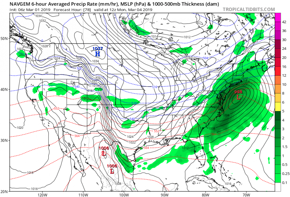
Navgem went southeast and is a coastal snowstorm and a lot of precipitation. A setup like this could gives us 6-10 inches of snow Sunday evening to Monday morning
-
All snow
heavy snow for our area no rain.
Fwiw jma is southeast
-
FWIW the JMA moved the cyclone southeast compared to the last 12z run.
-
1 minute ago, SnoSki14 said:
Euro probably overdoing the amplification given the progressive flow.
But it also has been the best performer overall so I can't discount it.
It’s slowly caving
-
1
-
-
8 minutes ago, Metasequoia said:
You have a map of said alot of precip?
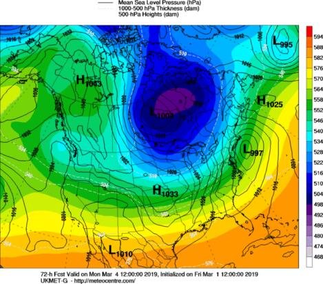
It’s all snow on ukmet
-
Just now, Snow88 said:
Alot of precip
We can get our 4-8 out of this if it’s stays all snow. This is fun
-
10 minutes ago, Stormlover74 said:
Ukie?
Classic nor’easter signature
-
1 minute ago, SnoSki14 said:
Oh how I wish the models were right and stayed the course.
Additionally, the timing would be really good (Sunday night - Monday morning) for March.
Euro is wrong here every model has a snowstorm for us except the euro
-
Gfs and icon are both all snow
-
Just now, NycStormChaser said:
Who said that has to be the end?

I know another storm next week lol
-
5 minutes ago, jm1220 said:
Better to expect little and be surprised on the high end than vice versa. It’s a much tighter rope getting this one to work out down here than over SNE. We need the low to develop sooner so the cold air can crash down, and it stay far enough SE to not allow warm mid level air in. The safe bet is for mostly rain around the city and coast. If the Euro goes notably cooler at 12z it may be time to bite on something better.
Fair enough. I hope we get a surprise tomorrow. I was definitely surprised this morning with the inch and half of fluff. My wife is a teacher and she got to work at 9am there was traffic everywhere today. People don’t understand they need to slow down it’s snowing outside. Than they get into an accident and you drive by them and you know what they’re thinking.
by the way I don’t think the euro is as good as it used to be. What happened to that model?
-
8 minutes ago, jm1220 said:
SNE didn’t seem happy with that Nam run which is probably good down here. Low in general ticked SE which meant a colder outcome. SNE crew is saying it may have been convection happy and kicked it east prematurely. The storm ramping up quicker may cool the column down faster and make it colder anyway. This’ll be quite tricky actually. I’m expecting practically nothing for the coast, mostly a washout so anything would be nice. Never fun watching Boston get slammed while we get soaked or nothing.
No offense John but you’re always expecting nothing. You’re in Long Island so it might get trickier for you but New York City is really in a good spot here.
-
5 minutes ago, Stormlover74 said:
Another very tricky forecast for central nj to NYC tonight and tomorrow
Why is this tricky... this is a 2-4 for New York City simple. Central New Jersey probably rain ending as some snow.
-
Euro?
-
Nice powdery 1.5 inches here in the bronx.
-
Just now, jm1220 said:
I'd be more comfortable with that if the Euro shows it too-it's hi res like those models. Right now the Euro still looks warm here. Hopefully overnight, the models cranking the storm sooner can crash the cold mid level air south sooner.
Nam gives us more snow than southeast ma that’s hard to believe. I’d toss it for now. They get the better dynamics don’t they?
-
2 minutes ago, HVSnowLover said:
NAM way west tomorrow night with precip and looks like 850s crash in times for snow for the city.
That’s a decent snowstorm for us looks like a 3-6 inches combing them together.
-
5 minutes ago, qg_omega said:
Best shot of snow is Friday night into Saturday morning for the coast. Monday is a rain storm
We don’t know that, 24 hrs ago saturdays system was a non event
-
3 minutes ago, ineedsnow said:
NAM will be north of 18z not a shock though
About to get nam’d
-
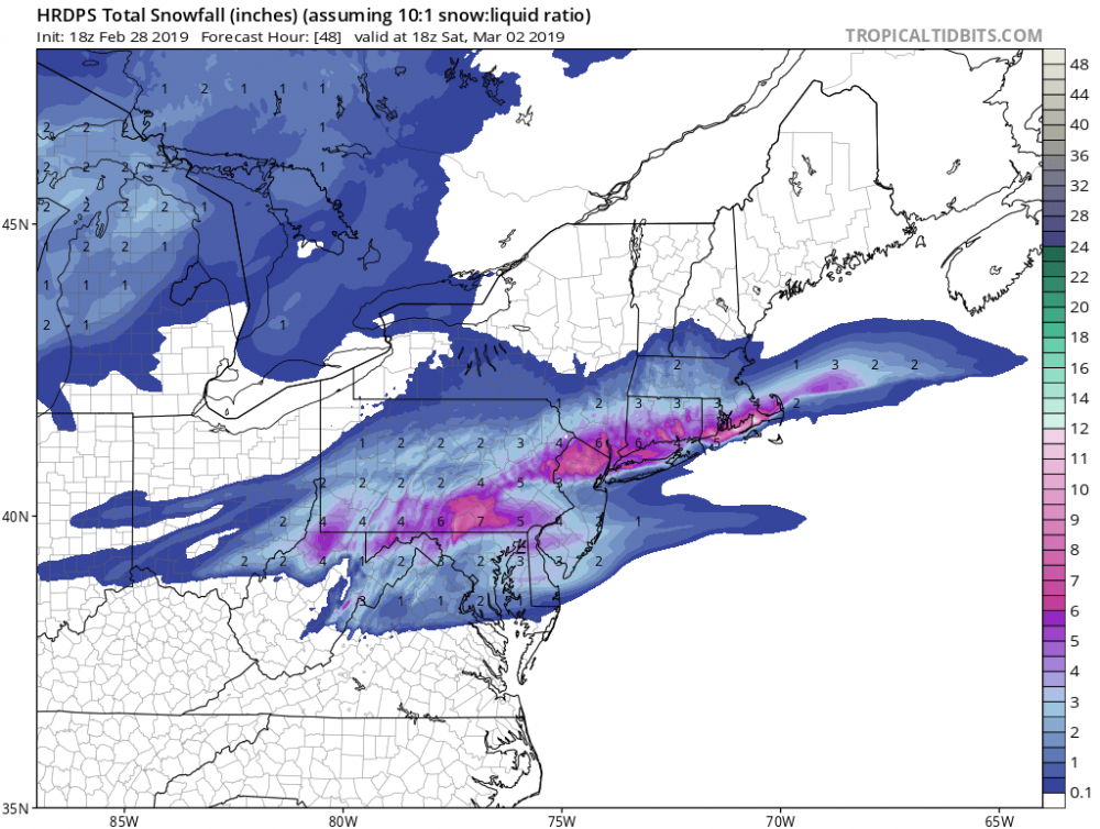
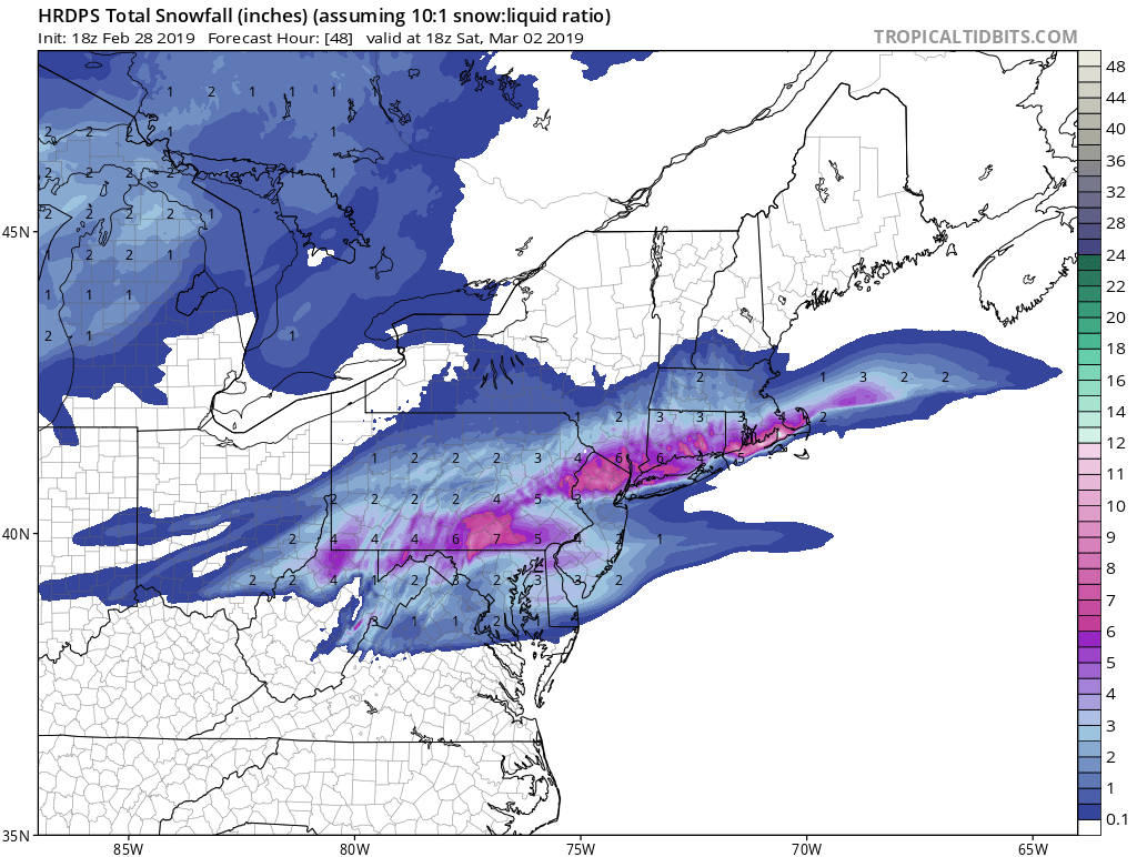
HRDPS looks really good for tomorrow morning and the coastal on Saturday. Combined between the two it dumps 4-6 inches of snow in New York City.
-
1
-
-
Snowmap lol?


March 3rd-4th Shellacking threat
in New York City Metro
Posted
Cause the low doesn’t go over us and as the low cruises to our southeast the PV is pressing down.