

WEATHERMINATOR
-
Posts
93 -
Joined
-
Last visited
Content Type
Profiles
Blogs
Forums
American Weather
Media Demo
Store
Gallery
Posts posted by WEATHERMINATOR
-
-
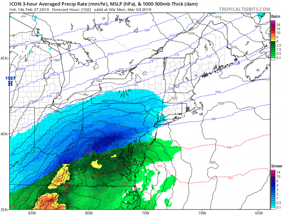
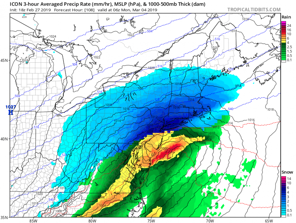
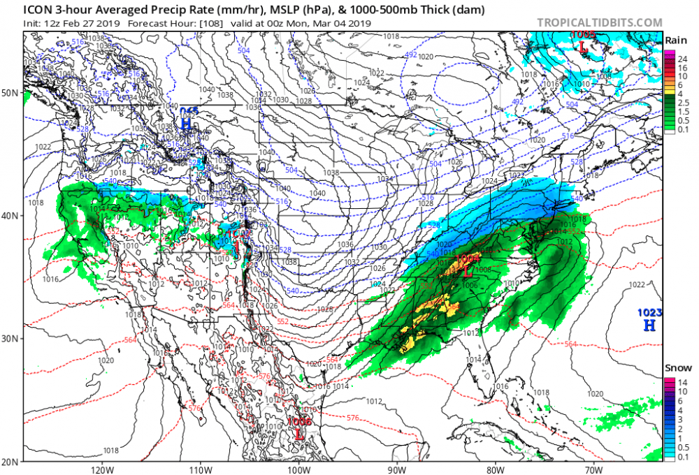
I like where we stand at this time for Sun-Mon system. It seems to me because of the fast flow that system has no chance of cutting or even hugging. It’s either out with a whiff or all snow. At this time I’d have to agree with the more snowy side because the storm is moving fast but it also has heavy precipitation 1-1.5 inches of QPF so the fast flow balances with the shift east which cools off columns and we snow. Plus models aren’t that bad in this timeframe, let’s be honest.
-
2 minutes ago, dmillz25 said:
With how this season has gone, take that shit and run
Facts
-
15 minutes ago, tavwtby said:
radar looks like shredded, I'm actually down in NC now, it was 70 here yesterday, again I'm away for the snow...wife says grap and grains falling not much of anything otg
You’re going to have a nice burst of snow around 1-4am that can give you 3-5 inches and nyc may get a heavy coating.
-
3 minutes ago, Snow88 said:
Ensembles look nice
Classic i95 DC to Boston shellacking.
benchmark track wins, we win!
-
 1
1
-
-
10 minutes ago, mikem81 said:
GFS gets pushed east a little too early, but decent run and exactly what we wanted to see after the EURO. GFS has a huge amount of cold air coming in as the storm hits and thats what shuns it a bit east.
Honestly bro that’s as best as it’s going to get because it’s a fast mover.
edit: gfs FV3 is a stronger storm and closer to coast, doesn’t look like any rain for the immediate nyc region but Long Island switches over. Too far to be looking at that now. Very nice pattern coming up
-
Just now, BombsAway1288 said:
You have to give pause that it's the ICON though. I would love that solution as much as you guys but sadly, it's the ICON showing that right now
ITs the same track as the eps and eps is the best model. In fact the eps is a bit southeast of the icon so that gives you that extra 50-60 miles of leeway for Long Island to enjoy a mostly snow event
-
1
-
-
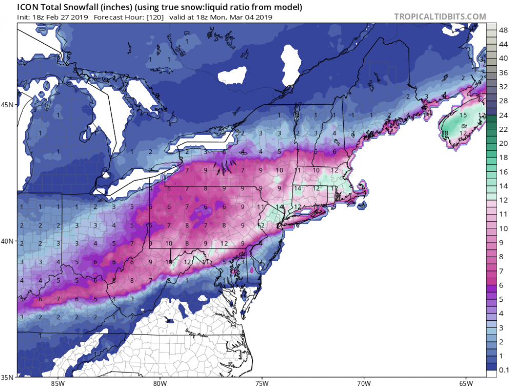
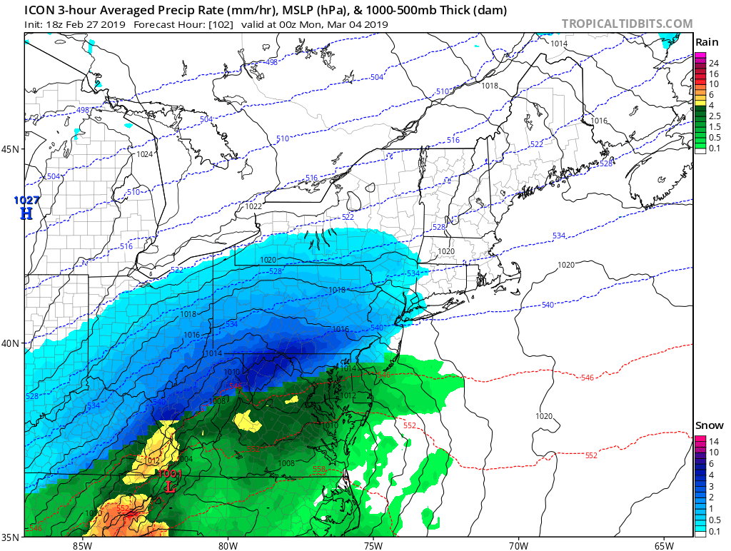
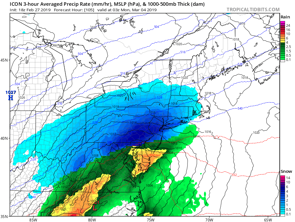
Icon is a foot of snow for Central Park. Very impressive snowstorm
sunday night and moves out by Monday at 7-8am

-
5 minutes ago, winterwx21 said:
It didn't go south but it's much drier. This 18z run gives a 1 inch snowfall for much of NJ, while the 12z run was 3 inches for central NJ.
It’s more consolidated meaning the precipitation shield is bigger which we needed if you want snow in New York City. Albeit it’ll be an inch or so but that plus Monday it’s looking very interesting times for tracking
-
58 minutes ago, snowman19 said:
No -NAO, SE ridge flexes, no -AO to lock the TPV in SE Canada, the TPV stretches and lifts north because there’s no AO block, storm will cut just like the Euro showed. Very believable scenario (cutter, rain) and IMO the most likely for Monday
You seen the eps
-
2 minutes ago, mikem81 said:
What does the UKMET show for Monday?
Snow event it’s got a nor’easter with a benchmark track
-
1
-
 1
1
-
-
Gfs looks solid warning snows for philly to Boston! Very good looking storm for monday
-
1 minute ago, ORH_wxman said:
Clown range rgem went wild for SNE this weekend...but I'm really waiting for ukie and euro. GFS has been struggling with this one in terms of consistency. All over the map.
Do you have the link to the extended rgem? I thought that only went to 48 hours
-
58 minutes ago, Sn0waddict said:
Incredible how far apart the NAM and GFS are for the Friday storm given it’s only 54 hrs away.
If I were to guess I’d think the Friday deal is a dud and than the boundary moves up north and we get a light event whether it’d be a rain/snow mix or white rain. But the Monday’s event could be big
-
Icon looks great for Sunday night into Monday maybe a tad warm but looks good imo

-
Icon looks like a big snowstorm coming maybe a bit warm but it does look good for Sunday night into Monday
-
Snowing lightly in armonk now. Precip seems more south than any model shows. Hopefully we get a surprise
-
2 hours ago, Snow88 said:
Eps is similiar to the Gfs
eps 6z is much better for monday. Perfect benchmark track
-
Just now, ORH_wxman said:
06z EPS is gung ho for Monday. So much in fact that it's giving ptype issues to SE areas...but given they are kind of the NW outlier at the moment, it's not the worst thing
How would the winds be with this storm. That’s a really nice look. Any chance we get a blizzard out of this or is it more of a low forming off a frontal passage?
-
19 minutes ago, Ericjcrash said:
Just a 1-3" scraper, but close.
I just don’t get how these models suck so much.
-
1
-
 1
1
-
-
Canadian is a big snowstorm for monday
-
1
-
 3
3
-
-
3 minutes ago, 87storms said:
Agreed and after I looked at the 12z gfs I didn’t want to say anything to bring the vibe down, but it looked squashy at h5. I don’t think the upper level pattern has been ideal all year. We’ve just gotten lucky with the progressive cold shots in an active pattern. That might hold true over the next couple weeks as well.
The gfs is the worst model I wouldn’t make my forecast based on the gfs. Everything is on the air at this time
-
10 minutes ago, snowman19 said:
Saturday does not look like 1-3 inches at all. It’s rain unless you’re in New England
It isn’t rain. Check the model
-
1
-
-
6 minutes ago, Stormlover74 said:
4-6"
There’s a coating to an inch Wednesday night. 1-3 for Saturday and 4-6 on Monday. And next Wednesday looks interesting for a big storm! Very nice run
-
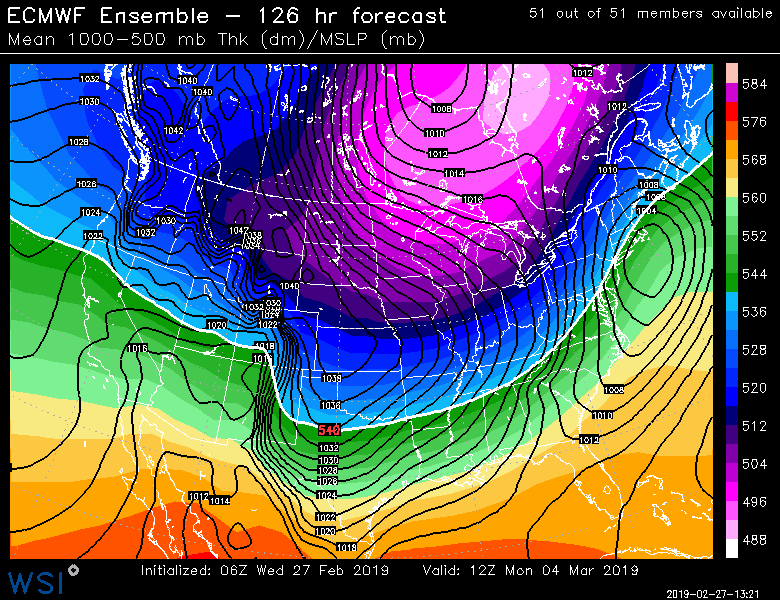
Euro with the run of the year


OBS thread Feb 27-28, 2019
in New York City Metro
Posted
It should snow around 1-4am