

WEATHERMINATOR
-
Posts
93 -
Joined
-
Last visited
Content Type
Profiles
Blogs
Forums
American Weather
Media Demo
Store
Gallery
Posts posted by WEATHERMINATOR
-
-
Anyway you guys can post something for us
-
4 minutes ago, HVSnowLover said:
The upper levels are too warm with the first storm and the city is not in the best location for that one, the best dynamics would be SNE and possibly even eastern LI
I disagree I think nyc and east is in the good dynamics if you take the gfs solution. The gfs FV3 is a string out mess for Saturday resulting a mix Sunday night. Obviously we have no consensus for neither storms yet
-
1 minute ago, HVSnowLover said:
It's not 3-5 inches but if the dynamics are strong it could push the 850 line down enough to flip the city to snow Saturday morning, I'd favor SNE for an accumulating snow event with that system
It is 3-5 considering the strength of the low and the poor gfs thermals, you got 6 hours of heavy snow in around the city
-
21 minutes ago, HeadInTheClouds said:
Don't believe the ICON for a second. Crap model.
Gfs is all snow for the city
-
Gfs is actually a nice snow event for the city for Saturday looks to be a good 3-5 inches.
edit: snowgoose said this and it seems like he’s right saturdays storm needs to be very strong and dynamic for the Sunday night event to be weak and a good snowstorm. And gfs is south for Sunday night which looks good haven’t seen the next panel but so far so good
-
Just now, Snow88 said:
Saturday event
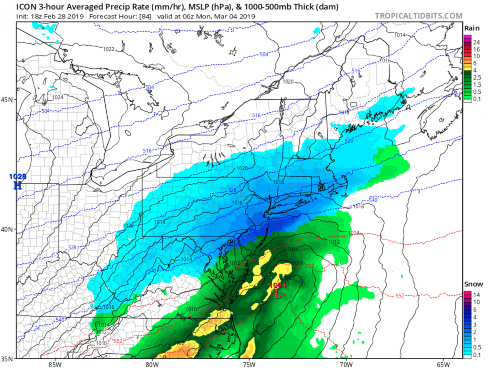
I don’t like saturdays event because the true cold air kinda gets stale. I like Sunday nights event more. Icon is a perfect example how we can get a real nice snowstorm.
-
Icon 18z is a true snowstorm for everybody.
-
 1
1
-
-
Just now, SnowGoose69 said:
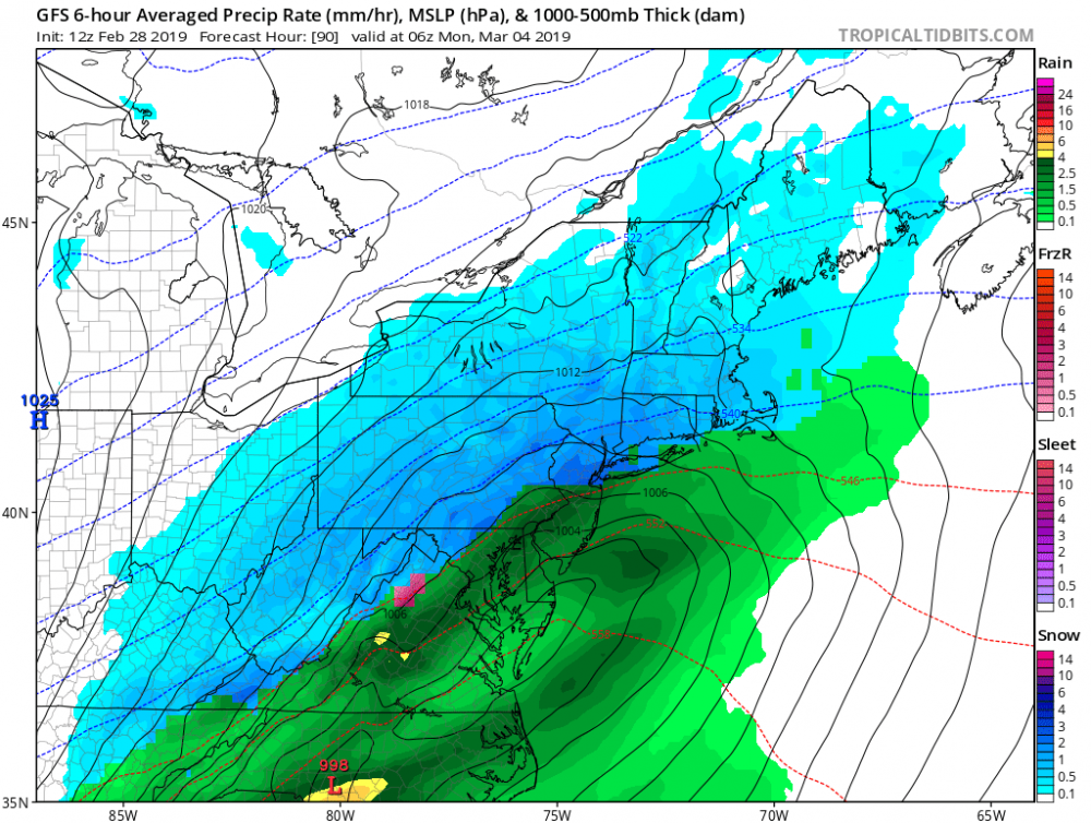
18Z ICON shows you what an amped Saturday does to help Sunday night
That’s the best look yet. But it’s too bad it’s icon. It’s not the worst though in my opinion. Navgem is
-
So did the eps move southeast or stayed the same?
-
GEFS look like a classic benchmark track

-
Just now, mikem81 said:
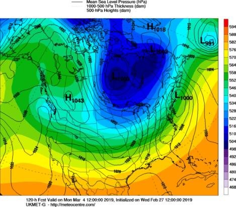
UKMET looks nice. a 997 maybe just inside the BM
Very nice look

-
6 minutes ago, gravitylover said:
Yeah I was pretty sure. Time to make him go away again.
Im not that person, I just figured we’d discuss each threat in its own thread. The moderators can delete them if they want but I noticed too many times we post stuff on the monthly thread and we miss important stuff with banter. This way we can discuss everything on its own. I didn’t do anything wrong here did I? If I did I’ll delete the threads sorry about the inconvenience.
-
Guys I made the threads for these two upcoming storms
-
Canadian is a bit warmer and more closer to the coast changes nyc to rain
-
GFS LOOKS GREAT
-
Just now, HVSnowLover said:
I personally don't trust any 96 hours out. The ECM showed over an inch of freezing rain for NYC with the 1/19 event like 72 hours out.
Euro is the best model but it has been caving to the gfs lately
-
5 minutes ago, NEG NAO said:
There is a way to get a snowstorm here out of the Sunday night/Monday system - I thought the 12Z 84 hour NAM had an interesting look to it - (AND I KNOW I SHOULDN'T BE LOOKING AT THE NAM PAST 60 HOURS !) if the southern energy is delayed and the cold enough air is allowed to build further south maybe the storm will track more to the southeast of us - but that Low in southern Canada in the NAM is not a good look unless it moves out of the way.

The stronger Saturday’s event the more south Sunday nights event will go. So I think you’ll see the models catch on to that idea imo
-
You guys have the ukmet snowmap up to 144hrs
-
Ukmet looks like the rest of tonight models runs. Don’t have the soundings but it does look good. Benchmark or slightly inside
-
5 minutes ago, HVSnowLover said:
GFS is a perfect run for the metro area for Sunday Night/Monday wish it wasn't still 4 days out
1 minute ago, NEG NAO said:but has been consistent - run to run continuity developing....BUT rain/snow line too close for comfort...….

Last run was better and colder but I’d take this run and sprint
-
Just now, HVSnowLover said:
Yea the city isn't getting a foot Monday like it previously showed, if the city gets 3-6 it would be a huge win in this winter. I'm not really paying much attention to the other two little events because neither seems like more than an inch.
Saturday could be good way better but the lifting is not being recognized by the models too much. Icon had a decent event there almost.
-
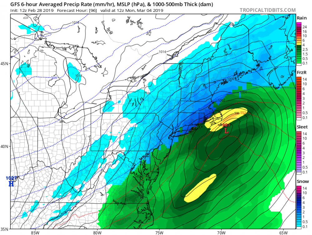
Icon looks a bit worse for monday but has some more snow for Saturday than it’s previous run. 1-3 for Saturday and another 3-6 for monday. Friday also has an inch.
-
The radar should blossom the next few hours in the area according to some models. The short range models are terrible right now and show no snow at all. We are definitely running saturated we just need that precipitation. We could get maybe 3 hours of some decent growth snow. It could be a half inch or sO, more to the north. 24 degrees outside with 60% humidity.
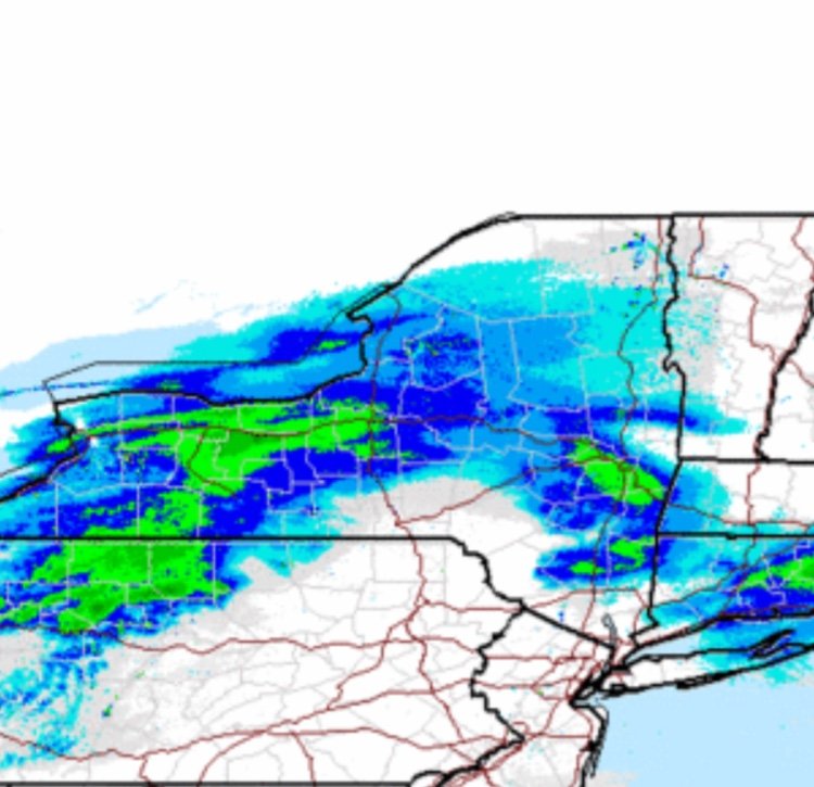 We need that precip that’s in northwest Pennsylvania to clip us which should be around 1am or so.
-
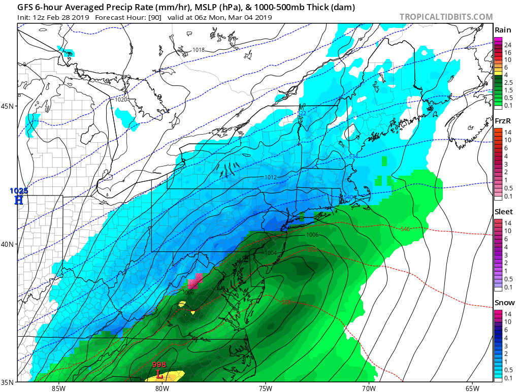
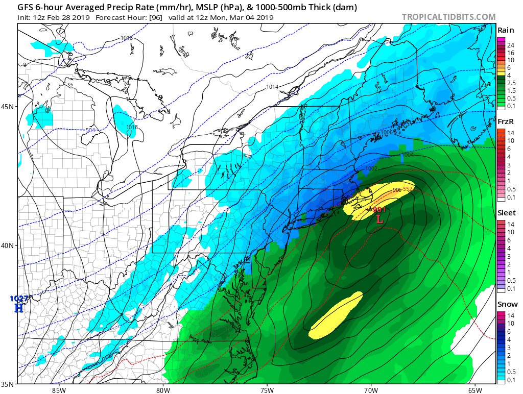
Looks like Nantucket with a win for this event.


March, 2019
in New York City Metro
Posted
How’s it look for our area