Delaware Valley Weather
-
Posts
156 -
Joined
-
Last visited
Content Type
Profiles
Blogs
Forums
American Weather
Media Demo
Store
Gallery
Everything posted by Delaware Valley Weather
-
E PA/NJ/DE Spring 2022 OBS Thread
Delaware Valley Weather replied to Hurricane Agnes's topic in Philadelphia Region
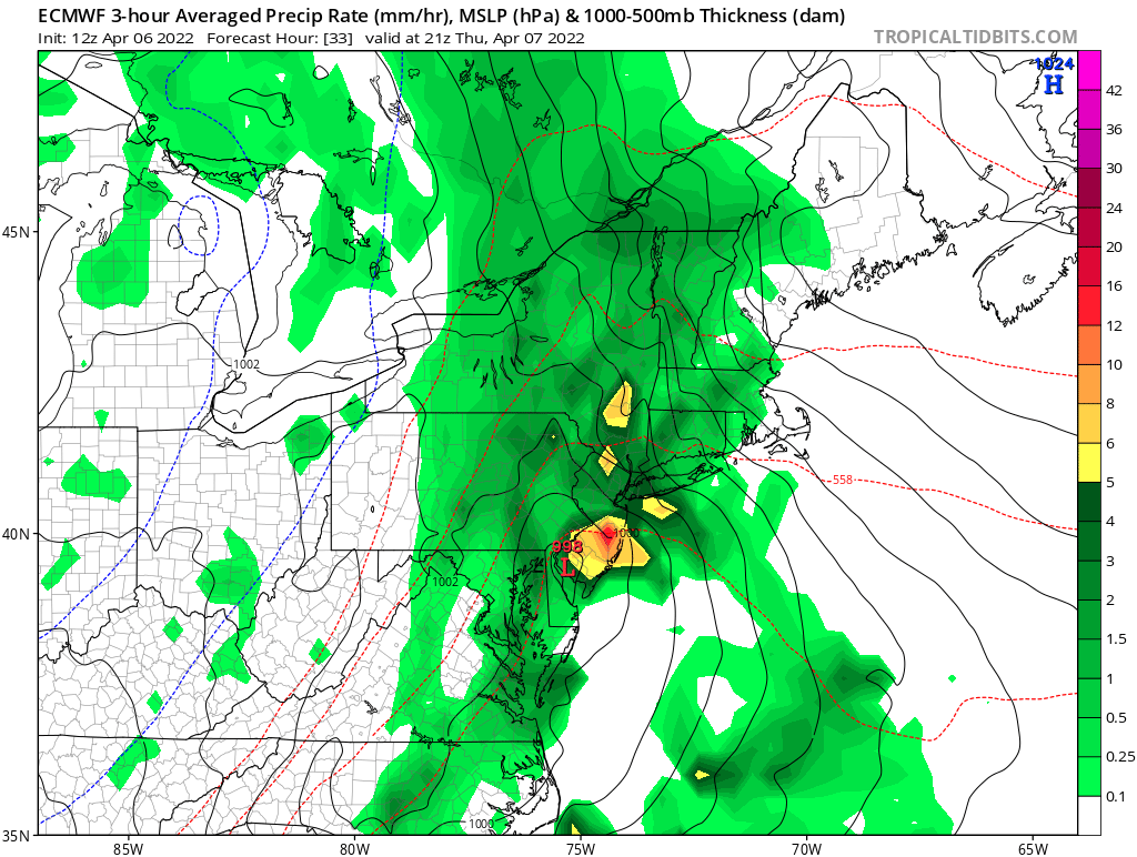
Went with a blend on Twitter of 1/2”-1” region wide. I’m sure we’ll see locally higher amounts but if the euro is right some places in Jersey will see 2”+.
-
E PA/NJ/DE Spring 2022 OBS Thread
Delaware Valley Weather replied to Hurricane Agnes's topic in Philadelphia Region
Ready for the next one.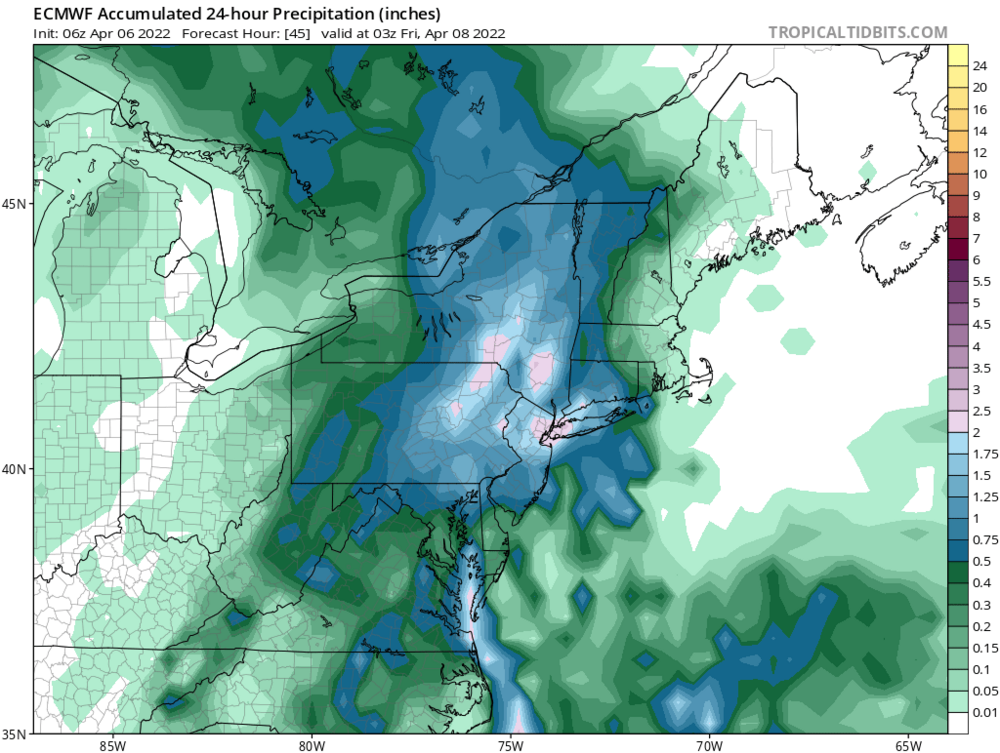
-
E PA/NJ/DE Spring 2022 OBS Thread
Delaware Valley Weather replied to Hurricane Agnes's topic in Philadelphia Region
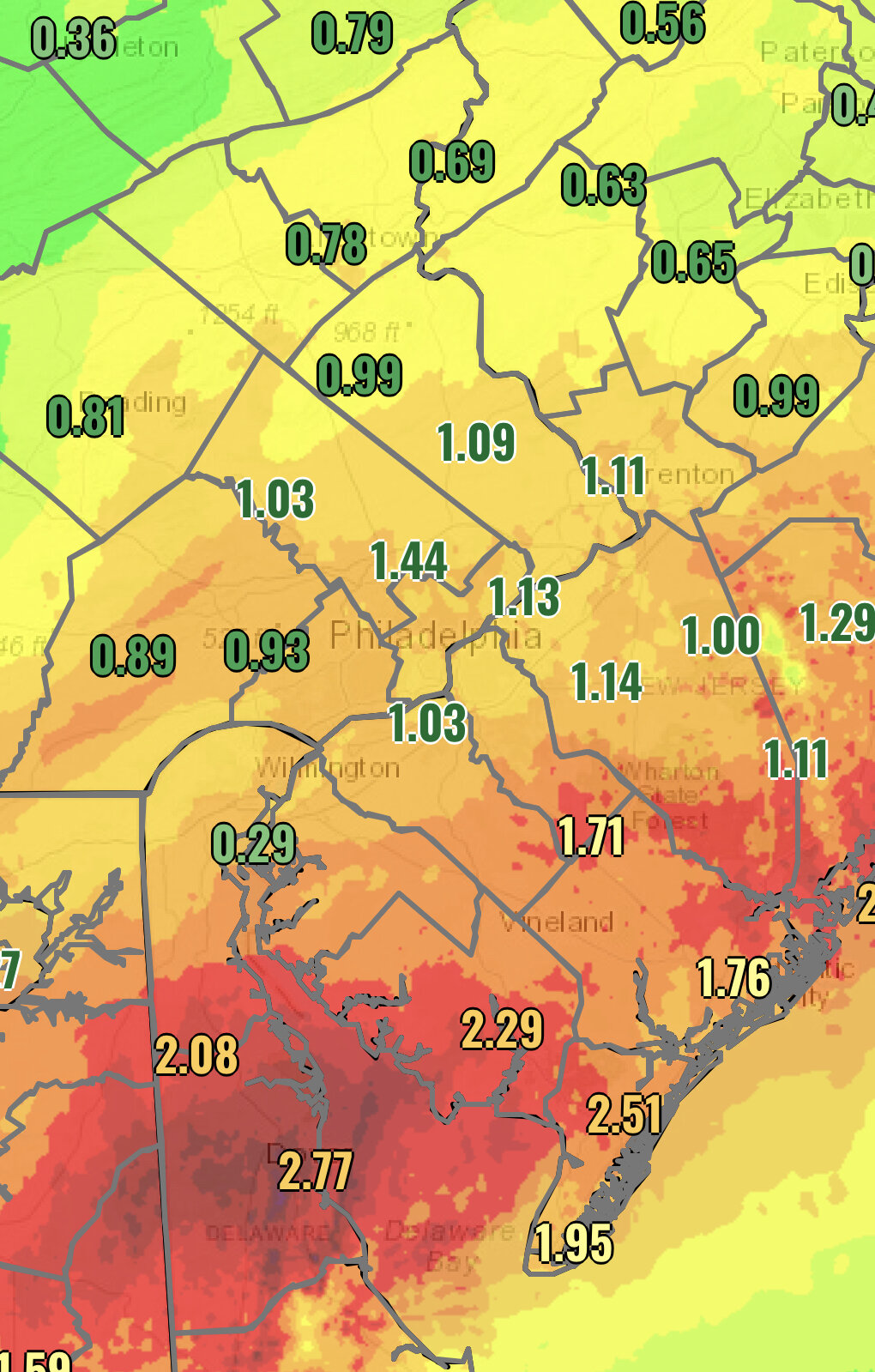
Totals from yesterday and this morning.
-
E PA/NJ/DE Spring 2022 OBS Thread
Delaware Valley Weather replied to Hurricane Agnes's topic in Philadelphia Region
Gfs finally coming in line with the euro.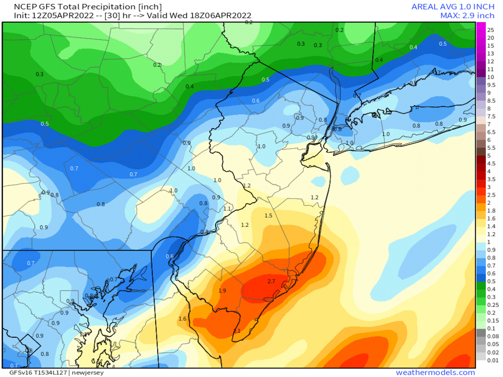
-
E PA/NJ/DE Spring 2022 OBS Thread
Delaware Valley Weather replied to Hurricane Agnes's topic in Philadelphia Region
Springs around here can be so frustrating. Not unlike winter lol -
Mid to Long Term Discussion 2021
Delaware Valley Weather replied to jburns's topic in Southeastern States
Nice day 10 cold shot on last nights euro
-
3.9” in Lionville. 1.9” last hour.
-
2.0” in Lionville at 830 30.2°
-
Coming down pretty good in Lionville. Looks like I’m closing in on an inch. Temp down to 29.8.
-
10.5” in Lionville.
-
All snow now in Lionville
-
January 3 - 4 Snow Sleet ZR and Rain to Snow obs
Delaware Valley Weather replied to ChescoWx's topic in Philadelphia Region
Moderate snow in Lionville, all surfaces covered. 32° -
E PA/NJ/DE Winter 2020/2021 OBS Thread
Delaware Valley Weather replied to Rtd208's topic in Philadelphia Region
We just had our snowiest decade ever and we are above average to date. -
E PA/NJ/DE Winter 2020/2021 OBS Thread
Delaware Valley Weather replied to Rtd208's topic in Philadelphia Region
Had a low of 9 this morning in Lionville. -
December 16/17 Snow Wall Obs Thread
Delaware Valley Weather replied to hazwoper's topic in Philadelphia Region
8” storm total in Lionville -
December 16/17 Snow Wall Obs Thread
Delaware Valley Weather replied to hazwoper's topic in Philadelphia Region
1/2” of sleet puts me at 6” for the storm here in Lionville. 25° -
December 16/17 Snow Wall Obs Thread
Delaware Valley Weather replied to hazwoper's topic in Philadelphia Region
5.5” in Lionville. Snow/sleet mix here now though. 25° -
December 16/17 Snow Wall Obs Thread
Delaware Valley Weather replied to hazwoper's topic in Philadelphia Region
2.5” in Lionville. 1” in the past hour. -
December 16/17 Snow Wall Obs Thread
Delaware Valley Weather replied to hazwoper's topic in Philadelphia Region
Flurries in Lionville -
E PA/NJ/DE Fall 2020 OBS Thread
Delaware Valley Weather replied to JTA66's topic in Philadelphia Region
33 was the low this morning here in Exton. Very impressive for any time in September. -
E PA/NJ/DE Fall 2020 OBS Thread
Delaware Valley Weather replied to JTA66's topic in Philadelphia Region
Made it down to 36 this morning in Exton. Had some very light frost in the backyard. -
March 2, 2019 Snow Event Discussion
Delaware Valley Weather replied to Ralph Wiggum's topic in Philadelphia Region
I think it’s going to be very close here in Exton but starting to feel good about 2-3.