
VOLtage
-
Posts
187 -
Joined
-
Last visited
Content Type
Profiles
Blogs
Forums
American Weather
Media Demo
Store
Gallery
Posts posted by VOLtage
-
-
This was an absolute worst-case scenario with it being a strong tornado, late at night, and a heavily populated area.
Praying for Nashville right now.
-
 2
2
-
 1
1
-
-
And poof... it's gone on the 18z run.
-
1
-
-
-
19 minutes ago, Stovepipe said:
How did that last band hit Maryville, any sticking to roads?
Any sticking up there in Knoxville?
-
12 minutes ago, Stovepipe said:
How did that last band hit Maryville, any sticking to roads?
Not any yet (at least where I live). But there's a solid inch in the grass, and it doesn't seem to be letting up any time soon.
-
I can't wrap my mind around why NWS Morristown hasn't at least issued an advisory.
-
1
-
-
-
The motion on the storm heading towards Crescent is incredible.
-
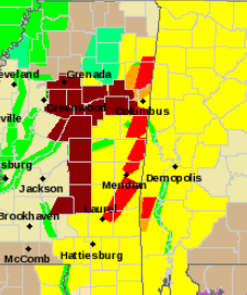
Severe Weather Statement National Weather Service Memphis TN 1131 PM CDT Sat Apr 13 2019 MSC057-095-140445- /O.CON.KMEG.TO.W.0021.000000T0000Z-190414T0445Z/ Itawamba MS-Monroe MS- 1131 PM CDT Sat Apr 13 2019 ...A TORNADO WARNING REMAINS IN EFFECT UNTIL 1145 PM CDT FOR SOUTHEASTERN ITAWAMBA AND NORTHEASTERN MONROE COUNTIES... At 1130 PM CDT, a confirmed large and extremely dangerous tornado was located near Detroit, or 10 miles northwest of Sulligent, moving northeast at 55 mph. This is a PARTICULARLY DANGEROUS SITUATION. TAKE COVER NOW! HAZARD...Damaging tornado. SOURCE...Radar confirmed tornado. IMPACT...You are in a life-threatening situation. Flying debris may be deadly to those caught without shelter. Mobile homes will be destroyed. Considerable damage to homes, businesses, and vehicles is likely and complete destruction is possible. Locations impacted include... Amory, Smithville, New Salem, Hatley, Gattman, Sipsey Fork, Quincy, Cardsville, Turon, Splunge, Wise Gap, Athens, Greenwood Springs and Parham. PRECAUTIONARY/PREPAREDNESS ACTIONS... To repeat, a large, extremely dangerous and potentially deadly tornado is on the ground. To protect your life, TAKE COVER NOW! Move to a storm shelter or an interior room on the lowest floor of a sturdy building. Avoid windows. If you are outdoors, in a mobile home, or in a vehicle, move to the closest substantial shelter and protect yourself from flying debris. Tornadoes are extremely difficult to see and confirm at night. Do not wait to see or hear the tornado. TAKE COVER NOW! && LAT...LON 3417 8840 3415 8819 3383 8824 3388 8849 TIME...MOT...LOC 0430Z 202DEG 46KT 3399 8828 TORNADO...OBSERVED TORNADO DAMAGE THREAT...CONSIDERABLE HAIL...0.00IN -
This is shaping up to be a major tornado outbreak.
-
5 minutes ago, jaxjagman said:
We probably need a thread
Done
")
-
1
-
-
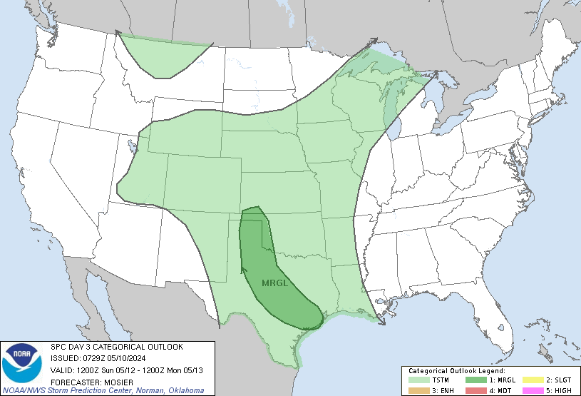
Day 1 Outlook:
Day 1 Convective Outlook
   NWS Storm Prediction Center Norman OK
   1112 AM CDT Sat Apr 13 2019

   Valid 131630Z - 141200Z

   ...THERE IS A MODERATE RISK OF SEVERE THUNDERSTORMS EAST
   TEXAS...NORTHERN AND CENTRAL LOUISIANA...WESTERN AND CENTRAL
   MISSISSIPPI...

   ...SUMMARY...
   Numerous to widespread severe thunderstorms are expected across
   parts of the south-central to southeast states through tonight. The
   most likely region for strong tornadoes is from east Texas to
   Mississippi, with the most dangerous period for tornadoes being
   between about 2 to 8 PM CDT.

   ...TX to TN Valley...
   No substantial changes to categorical areas with this outlook
   (beyond reducing area behind the convective line in TX).

   Surface cyclone near College Station should move northeast towards
   northwest LA and then across the Mid-South through tonight, as a
   warm front advances north from southeast TX/central LA. Parameter
   space is very supportive of supercells, with persistent
   warm-advection north of the front yielding a risk for large hail.
   Along and south of the front, main uncertainties are longevity and
   discreteness of favorable storm mode. A deeply moist boundary layer
   with upper 60s to lower 70s dew points will spread north, supporting
   preconvective MLCAPE ranging from 2000-3000 J/kg across southeast TX
   and southern LA. Such buoyancy will be quite favorable for all forms
   of severe, amid strengthening deep shear related to the approach of
   the mid/upper trough. Furthermore, low-level shear vectors and
   hodograph sizes will be quite large along and south of the warm
   front (from the Sabine Valley eastward), with forecast soundings
   yielding 250-600 J/kg effective SRH. Any sustained supercells in
   this environment will be capable of significant tornadoes.

   With time this evening and overnight, convection should organize
   into a roughly north/south-aligned band over the Lower Mississippi
   Valley region, as deep convergence becomes better-focused in the
   mass response ahead of the synoptic wave. As this occurs, the main
   threat in a bulk sense may become damaging wind tonight. However,
   given the strong inflow-layer SRH, tornadoes still will be probable
   from both embedded supercells and QLCS mesovortices.

   ...Central/eastern NC...
   Scattered thunderstorms are expected to develop through this
   afternoon, offering the potential for locally strong wind gusts and
   marginally severe hail.

   Mid/upper-level support will be lacking, beneath a belt of
   southwesterlies aloft. But the region will straddle a low-level
   moist axis characterized by surface dew points generally in the
   mid/upper 60s F, supporting preconvective MLCAPE from 1000-2000
   J/kg. Though low-level flow will be weak, limiting boundary-layer
   shear and hodograph size, the height gradient will remain
   sufficiently tight aloft to support strong storm-relative winds in
   upper levels, and effective-shear around 40-45 kt. As such, a few
   organized multicells and sporadic supercell structures will be
   possible. Storm intensity will diminish after sunset.
-
Tomorrow's going to be nasty for East Tennessee (where I live unfortunately).

-
1
-
-
-
Keeping a close eye on the line of cells in middle/north Alabama right now. If they don't fizzle out, these could affect the East TN valley.
-
24 minutes ago, METALSTORM said:
Indystorm I've noticed the maps for each forecast office seem to be stuck. LSX and SGF have been showing the same SVR polygon for a few hours now. JAN and MEG are not showing the tornado watch on their maps and the flash flood warnings are not updating on their maps either. The NOAA national map seems to be ok but the individual offices seem to be having a software problem.
They had better get their act together on an active day like today.
-
Here's my recorded rainfall since 12:00AM this morning here in Maryville.

Here's the recorded rainfall each day of the past week.

Adding up the total for each day comes out to 8.52 inches of total rainfall over the past week with more to come tonight.
-
They just issued a PDS Flash Flood Warning for Knox county.
The National Weather Service in Morristown has issued a

* Flash Flood Warning for...
  Knox County in east Tennessee...

* Until 130 PM EST.

* At 1036 AM EST, emergency management reported heavy rain across
  the warned area. Up to 3 inches of rain have already fallen over
  the last 3 to 4 hours with an additional 1 to 2 inches possible
  over the next 2 hours. Flash flooding is already occurring.

  This is a FLASH FLOOD EMERGENCY for Knoxville. This is a
  PARTICULARLY DANGEROUS SITUATION. SEEK HIGHER GROUND NOW!

* Some locations that will experience flooding include...
  Knoxville, Oak Ridge, Alcoa, Farragut, Louisville, Plainview,
  Halls, Blaine, Karns, Kimberlin Heights, House Mountain State Park,
  Lake Forest, Maloneyville, Mascot, Bearden, Powell and Seymour.

PRECAUTIONARY/PREPAREDNESS ACTIONS...

Move to higher ground now. This is an extremely dangerous and
life-threatening situation. Do not attempt to travel unless you are
fleeing an area subject to flooding or under an evacuation order.
-
There's tornado warnings and a winter weather advisory going on simultaneously in Southwest Missouri.
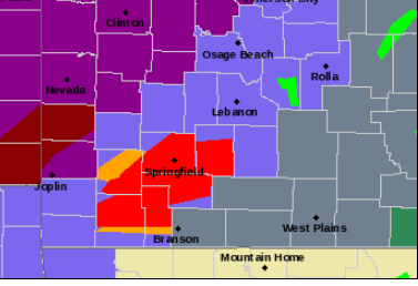
I don't know if I've seen anything like that before.
-
2
-
 1
1
-
 1
1
-

April 12 Severe Threat
in Tennessee Valley
Posted
Not April 27th bad. Maybe April 15th 2011 bad.