
VOLtage
-
Posts
187 -
Joined
-
Last visited
Content Type
Profiles
Blogs
Forums
American Weather
Media Demo
Store
Gallery
Posts posted by VOLtage
-
-
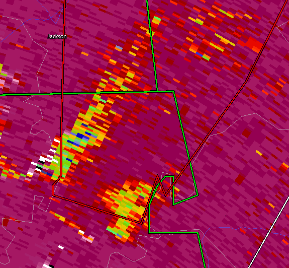
That is an insane debris ball.
-
Quad-state tornado?
-
Samburg is taking a direct hit.
-
One of the craziest couplets I've ever seen.
-
1 minute ago, Chreeyiss said:
It seems to be maxing out the velocity scale in both directions now on RadarScope. This couplet is absurd.
I don't know if I've ever seen a couplet like that before.
-
Is it just me or does that look like two separate debris signatures?
-
 1
1
-
-
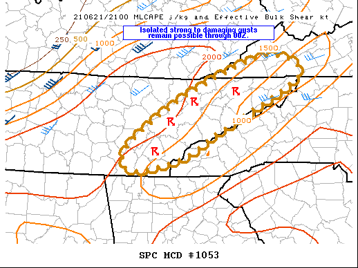
SUMMARY...Thunderstorms will continue to pose a risk for a few
   strong to damaging gusts through about 00Z, followed by an overall
   decrease in intensities. Due to the limited duration of remaining
   threat, a WW will probably not be necessary.

   DISCUSSION...Widely scattered to scattered thunderstorms continue
   developing in the pre-frontal warm sector across eastern TN where
   the atmosphere remains moderately unstable with up to 2000 J/kg
   MLCAPE. Latest VAD wind profile from Morristown shows unidirectional
   west southwest winds from 30-40 kt in the 2 - 6 km layer but with
   weak vertical shear. This environment is supportive of multicells
   capable of producing locally strong to damaging gusts. The primary
   threat should persist another couple of hours, but storms should
   begin a weakening trend after 00Z as the boundary layer stabilizes
   with loss of diurnal heating.
-
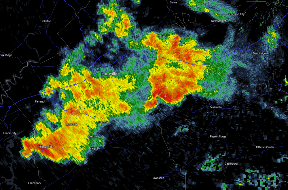
Keeping an eye on that storm to the north. Kind of has that "look" to it.
-
Very nasty looking couplet on the Campbell county storm.
-
Even besides the storms that are tornado warned, there are several other cells in Western Tennessee that are showing rotation.
-
9 Active tornado warnings right now.
-
New Tornado Warning on the cell farther East.
-
Looks like the couplet is going to hit just north of Scots Hill TN
-
This thing could hit Atlanta. I pray that doesn't happen.
-
 1
1
-
-
Keeping an eye on the supercell near the Mississippi /W TN state line
-
1
-
-
New Tornado Watch up for Middle Tennessee, Western KY, Southern IL, and Southern IN.
https://www.spc.noaa.gov/products/watch/ww0051.html
-
Cell north of Tuscaloosa is just starting to rotate.
-
Those cells in Southern mississippi look like they have lots of potential
-
We've got 10 ongoing tornado warnings.
-
Just now, jpeters3 said:
Lol, just as the weenies start to call bust, the "junkvection line" starts to turn into supercells. Look at eastern MS
Agreed. It's way too early to be calling this a bust.
-
2
-
-
I sincerely hope this isn't a sign of more things to come later...
-
Reports of people being entrapped in homes in Pelham.
-
Wow. James Spann's stream is showing a monster
-
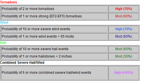
This is not good. This is about a worse-case scenario.
-
1
-

Dec. 10-11 Severe Weather
in Lakes/Ohio Valley
Posted
"Complete destruction is possible"
Just unreal. Praying this thing weakens.