
VOLtage
-
Posts
187 -
Joined
-
Last visited
Content Type
Profiles
Blogs
Forums
American Weather
Media Demo
Store
Gallery
Posts posted by VOLtage
-
-
Confirmed tornado on the ground east of Scottsboro, AL.
-
 1
1
-
-
Just now, PowellVolz said:
Where you at? I can’t remember.
.Southern part of Maryville
-
2
-
-
There’s at least 3 inches now on my deck.
-
3
-
 3
3
-
-
Got roughly 1.5 inches so far here in Maryville and it’s still coming down good. The roads look treacherous.
-
4
-
-
Well that was a bust, in a good way.
-
1
-
-
Keeping a close eye on this cluster of cells near the TN/AL border. They'll be moving into a pretty favorable kinematic environment.

-
-

Probability of Watch Issuance...80 percent

   SUMMARY...A severe threat may develop with storms that initiate
   along a cold front, posing a threat for damaging gusts. A couple
   instances of severe hail/tornadoes are also possible.

   DISCUSSION...Storms have struggled to develop within the warm sector
   environment 50-150 nautical miles ahead of the cold front despite
   ample diurnal heating and the presence of adequate buoyancy.
   However, storms have been developing along and immediately behind
   the cold front over the past hour. An uptick in storm coverage and
   intensity is possible over the next few hours as the cold front
   continues to progress eastward. The 500-1500 J/kg MLCAPE, driven by
   60-65 F surface dewpoints and steep low-level lapse rates, along
   with 40+ kts of effective bulk shear suggest that damaging gusts may
   be the main threat with the more organized multicells/transient
   supercells that can develop. However, a few surface observations
   along a CHA to CPF line show some backing of the surface winds. Any
   storms that can mature amid these back winds may exhibit at least
   brief bouts of strong low-level rotation, with severe hail and a
   couple of tornadoes possible.
-
1
-
-
The sun has been out for a while now here in Maryville.
-
1
-
-
Looks like another tornadic supercell is hitting the areas just affected by the last one in SC.
-
-
I ended up with 6" here in Maryville.
-
5
-
-
The wind has really picked up
-
4
-
-
Absolutely ripping where I’m at
-
4
-
-
Knoxville is in prime position for this band. Looks like the bulk of it will miss north of Maryville
-
1
-
-
Looks like a nice heavy band about to move in
-
3
-
-
I’m going to bed now. Got my alarm set for 4:30 am.
-
2
-
-
13 minutes ago, PowellVolz said:
.
-
1
-
 4
4
-
-
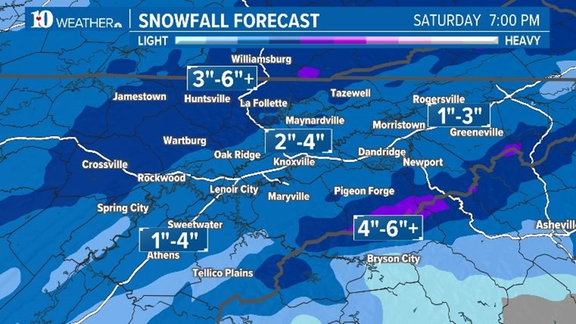
WBIR's snowfall map is even more conservative than MRX's
-
1
-
-
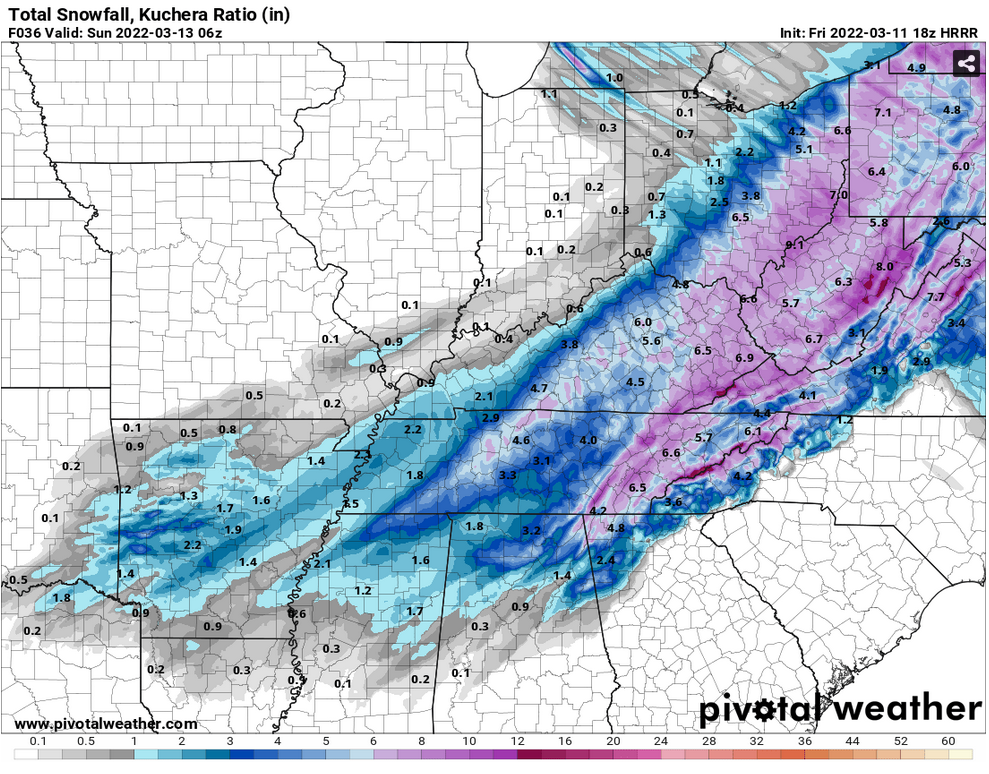
39 minutes ago, Mrwolf1972 said:
0z nam wow
.thumb.png.fdfc53ae79c99314081123b9c215aaa8.png)

-
3
-
2
-
-
It feels amazing for the Valley to finally be in the bullseye of one of these systems.
I'm also happy that it seems that Chattanooga will finally cash in on it. They're long overdue for a good snow.
-
4
-
-
Latest HRRR is nice

-
2
-
-
May need blizzard warnings on the plateau with the potential for those 40+ mile per hour winds.
-
3
-
-
This system is insane. There will be a pretty decent threat for tornadoes farther south in Georgia and Florida.
-
1
-
.png.231dd61e1d54814e483757ce41b35b7e.png)
Severe Weather 4-4-23 and 4-5-23
in Lakes/Ohio Valley
Posted
What a monster storm