

Jessy89
-
Posts
197 -
Joined
-
Last visited
Content Type
Profiles
Blogs
Forums
American Weather
Media Demo
Store
Gallery
Posts posted by Jessy89
-
-
These flakes are fatties in Maggie valley probably a inch on ground
.-
 3
3
-
-
Snowing good in Maggie valley now
.-
4
-
-

Arrived at my riverside motel in Maggie valley! Hoping this all turns white this evening and tonight
.-
8
-
-
Wonder when GSP rolls out a warning for western NC?
. -
If the NAM has a warm nose I certainly wouldn’t discredit it. NAM is normally really good in its range. Maybe take a blend of NAM and hrrrrr
.-
1
-
-
As for the mountains of NC. Going to Maggie Valley I think I’ll see snow after 6pm maybe lasting through 10 or 11pm but then mixing issues sleet even freezing rain. But then I noticed the low In Tennessee bringing a round two of snow 2am to 6-7am so really the mountains see two thumps. The upstate and ne Georgia a window of opportunity maybe 7pm to midnight then sleet and rain.
. -
This is a close approach if not a landfall. But either way it’s 40-50mph tropical storm. Stay inside all will be fine
. -
I don’t mind cool temps even in spring and summer. I’d love to average around 85 all summer with low humidity. You can do all you summer activities in 85 degrees
.-
1
-
-
There saying possible tornado touchdown off wade Hampton and pleasantburg drive in Greenville lot of trees down can anyone confirm?
. -
I was stunned when I made this thread earlier. I figured a thread would of already been made. This certainly did live up to expectations
. -
Guess I’ll hang around in Pickens and see if that 2nd cell produces
Did the wind even get up in Pickens at all?
. -
Yup I’m just south of Pickens Pickens I see the cell to my north
. -

This one may bring some large hail to ne Georgia upstate sc and western nc surprised no ones talking about it.
.
-
Is this bad?...

Sent from my LML212VL using Tapatalk
Of course that’s bad
.-
1
-
-
I think this one will stay a lot further south then the last
. -
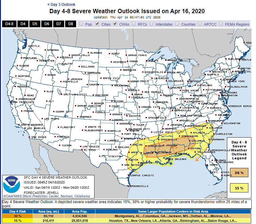
ZCZC SPCSWOD48 ALL ACUS48 KWNS 160845 SPC AC 160845 Day 4-8 Convective Outlook NWS Storm Prediction Center Norman OK 0345 AM CDT Thu Apr 16 2020 Valid 191200Z - 241200Z ...DISCUSSION... Models have come into better agreement depicting a shortwave trough moving quickly from TX Sunday/D4 morning to GA by 12Z Monday/D5. Low pressure is forecast to develop over the Red River during the day Sunday, shifting east toward the lower MS Valley by 00Z. Ahead of the low, a warm front will lift north across the Gulf Coast states, with upper 60s F dewpoints likely into central MS, AL, and GA, with low 70s F along the coast. MUCAPE to at least 2000 J/kg is likely by 18Z from TX into AL, with strong westerly winds aloft and 500 mb temperatures on the order of -10 to -12 C. Storms are forecast to form relatively early over east TX, where the environment will support large hail and damaging winds. Supercells are possible initially, with an eventual MCS likely. A tornado or two will be possible despite marginal low-level shear. Meanwhile to the east, warm advection may support supercells well ahead of the MCS across MS, AL, GA, producing a tornado or two along with hail. The primary severe risk in terms of coverage will likely be an MCS tied to the surface low as it quickly moves along the east-west instability gradient across LA, MS, AL and into GA. Significant convective feedback is present in the models, supporting the notion of a well-defined MCS with damaging winds. While SRH will not be very strong initially, it should increase after 00Z, with enhanced wind and/or tornado potential. The corridor of maximum threat will likely be adjusted in later outlooks.
Lordy I hope this isn’t like the past event.
.-
1
-
-
Hope y’all N.C. peeps are as lucky with your analfrontal snow , as you are at clippers!

Us here in upstate just have to wait. Our snow will come.
. -
Will it snow probably not outside the mountains. But this is similar setups we like to see December through February.
. -
Most events in November not realistic anyway.
.-
1
-
-
Euro seems interesting!

Snowing where?
. -
I'll take this look @ 150hrs anytime. And considering this is the first week of November


If that high can be 10 mb stronger. A lot of areas could see ice in November!
. -
I don’t expect the GFS to be accurate this winter either
.-
 1
1
-
-
Anyone else notice the coldest air of season around Halloween. Potential for 20s as far south as upstate S.C.
. -
I have a gut feeling the United States will see one big land falling hurricane. Just my gut could be wrong
.
2/6/-2/7 Snow Threat
in Southeastern States
Posted
Inch in Maggie valley maybe it’s more a light snow now. If it could stay heavy I could see us getting 4 inches or so. But it’s light snow with heavy snow at times. I think we end up with 2-3
.