miamarsden8
-
Posts
114 -
Joined
-
Last visited
Content Type
Profiles
Blogs
Forums
American Weather
Media Demo
Store
Gallery
Everything posted by miamarsden8
-
I can promise you it won't unless we get a sick, sick band. I'm talking 1-2" an hour.
-
Seriously, like...why lol. I'm about 10 mins SE of Hamilton. This is just unfortunate. Hopefully it builds behind that dry slot or the event may be over for me. Good luck to everyone in Indiana and NW Ohio! GG! I hope to see the pictures.
-
Like this is a nasty dry slot. Why.
-
I'm concerned about that dry slot in western Kentucky. I think that's going to nuke snow totals around here. I think I'm boned at this point if that dry slot doesn't fill in... Crap.
-
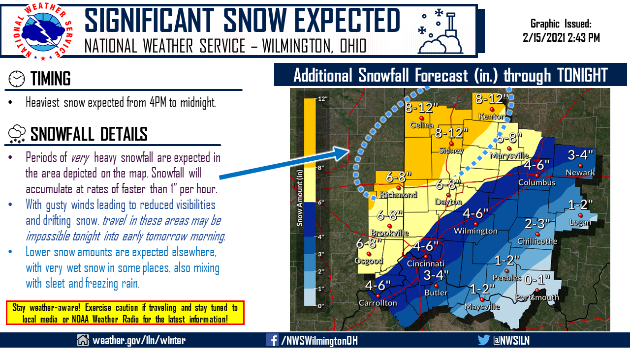
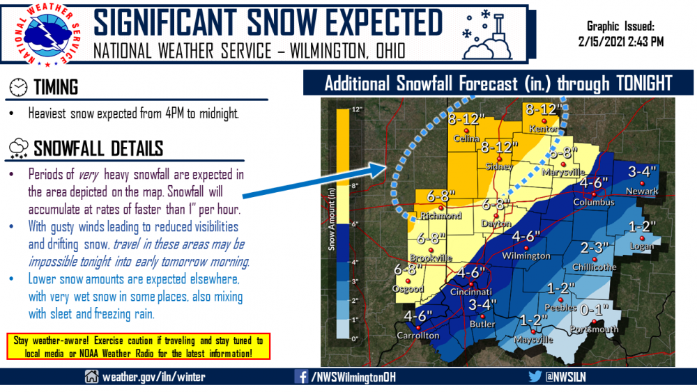
Latest from ILN... AREA FORECAST DISCUSSION National Weather Service Wilmington OH 339 PM EST Mon Feb 15 2021 .SYNOPSIS... Significant winter storm to continue to impact the region overnight into early Tuesday as surface low pressure tracks into the Upper Ohio Valley. Surface high pressure will settle over the region bringing dry weather and cold temperatures Tuesday into Wednesday. Another system with a similar trajectory will create another round of winter weather for Wednesday night and Thursday. && .NEAR TERM /UNTIL 6 AM TUESDAY MORNING/... Major winter storm to continue to impact the area tonight into early Tuesday. This storm will likely cause a range of impacts from very heavy snow up to a foot across portions of East Central Indiana and West Central Ohio to up to a half inch of ice over the Scioto River Valley/Southeast Ohio and portions of Northeast KY. Model solution consensus toward more amplified mid level trof. This leads to further west and deeper surface low. This allows more warm air aloft over the very cold surface temperatures. Precipitation beginning to re-develop and fill in from the southwest as favorable lift re-develops. This pcpn initially is falling as freezing rain/sleet along the I-71 corridor. 8H Frontogenesis intensifies this evening with a dual upper level jet band providing upper level divergence. Expect snowfall rates this evening to be 1 to 1.5 inches per hour in heavy snow over the northwest portion of ILN/s FA. Confidence in heavy snow over the northwest is high. With more warm air into the I-71 corridor this region will be in the transition zone of pcpn types. Sleet and freezing rain will diminish snow totals in this transition zone -- with 5 to 8 inches expected overnight. Over the lower Scioto River Valley and northeast KY the predominate precipitation type is freezing rain. Major ice accumulation up to a half inch is forecast overnight. This amount of ice will likely lead to power outages and tree limbs down. With sfc low tracking thru the Upper Ohio Valley overnight expect the pressure gradient to increase tonight -- especially over West Central Ohio. North-northeast winds gusting up to 35 mph will result in blowing and drifting snow overnight. Have continued winter storm warnings across the entire area. Cold temperatures to continue with lows from near 10 northwest to near 20 southeast. Cold wind chills in the single digits thru the daylight hours. Large surface to build into the Great Lakes/Ohio Valley Tuesday night. Very cold temperatures with lows from the single digits below zero northwest to the single digits above zero southeast. Wind chill look to be single digits below zero.
-
If Fairfield is any indication, it's coming. These flakes are massive.
-
If you wanna send some just east over the border into SW Ohio, we'd love you forever.
-
Heavy snow in Fairfield now. Ripping pretty decently.
-
For folks in the Cincinnati area, it's going to come down to snowfall rates. I think that's the reality of all of this, and it's really unfortunate.
-
NO Don't do me like this!!!!!!! Give me higher rates! Pleeeeease?
-
In Fairfield, at least from my window, it's light snow. It's literally like a 15-mile difference. It's absurd.
-
Like, I'm on the north side around Fairfield, so my odds are still decent, but also, I don't like how close the sleet is at all. I know I can't be the only one near Cincy getting nervous. Mason is getting sleet, and that's about 20? minutes east. This is way too close for comfort.
-
It's also nerve-wracking to be on the eastern edge of this thing. The further west it goes, the less optimistic I'm getting.
-
If that isn't the single most western-central Illinois thing I've ever seen...
-
Furthermore, if the maps are based on 17:1 ratios, I know areas down south were hitting 20:1 ratios apparently, so it would make sense if those turn out to be correct, but of course, I'm not qualified to speak on whether that will continue up here.
-
Flurries/lt. snow with some blowing in northern Cincy suburbs now. It begins!
-
The reality is that this is a very historic event potentially if all plays out as it should.
-
FOR ILN: .SHORT TERM /6 PM THIS EVENING THROUGH 6 PM TUESDAY/... A stronger wave will eject out the longwave trough later today. Guidance provides confidence that precipitation will blossom across the region mid-late afternoon today, with rates quickly increasing as a corresponding surface low intensifies and lifts from the Tennessee Valley into southwest PA late this evening. ECMWF going more amplified for the 00Z run, and other models coming in line with this. The result is higher confidence in the previous 12Z package shifting the surface low path to the west, as a blend of several model solutions consistently provides sleet and freezing rain in the southeast. This leads to heavy snow from the I-71 corridor back to west central Ohio and east-central Indiana. In addition, the more amplified pattern leads to higher QPF, so storm total snow grids now yield 7-11 inches in the all-snow areas northwest of I-71 and 0.1 to 0.3 inches of ice in the southeast. Woudn`t be surprised if the gradient between heavy snow and sleet/freezing rain needs tightening up with upcoming updates -- especially from northern Kentucky through central Ohio. Have also kept blowing snow in the weather grids this evening during peak snowfall rates. Winds gusting around 25-30mph are not out of the question. Low will eject northeast Tuesday morning with a chance of flurries remaining in the very cold air behind the low. Low temperatures in the teens Monday night will slowly increase to high temperatures a few degrees on either side of 20 Tuesday.
-
That's what I'm trying to figure out myself. It could mean 2-3 extra inches or it could mean a faster storm, I have no clue. Anyone hearing anything on how this'll affect it?
-
As someone who used to live in Macomb -- ILX does that a lot. No clue why.
-
I was actually about to note that. Reading the radar, it looked like it was at least an hour ahead of accuweather's projections. Is this a good or bad thing though? I'm uncertain...
-
I want to see the gfs and euro before I panic.
-
Can we not? Don't screw me!!!
.jpeg.5cd95c14b8250debfbc054001100c916.jpeg)
-
15:1 could be possible though yeah? Because at 15:1 even that's absurd.
-
So if that's the case, I'd argue Cincys total is probably closer to 12 than the forecast 6-9. My call of 6-10 might be lower that it should be.