
Scud
-
Posts
254 -
Joined
-
Last visited
Content Type
Profiles
Blogs
Forums
American Weather
Media Demo
Store
Gallery
Posts posted by Scud
-
-
Just now, stormtracker said:
GFS is about to screw us with a slider. But hey..180+ hours. Just glad we got something to track finally.
And everyone said Amen
-
9 minutes ago, stormtracker said:
Well the 5th looks dead on the GFS. So....,
Let's give the super computers a little more time....
-
2 hours ago, losetoa6 said:
Have you noticed this threats timing has slowed. Its still in the day 5 range . Just small changes ( at 120 hr leads no doubt) could allow for a nice little event . Heck.. I saw 1 0z gefs member (P004) that closed off at h5 and crushes many areas .
The potential has been predicated on energy moving out of the Rockies and attivating the stalled frontal boundary NE Gulf. This has left us with a series of surface waves at this point, and any development delayed in the models. What we know. Quasistationary boundary still there. Vortmax could amplify broad 500mb trof. Energy has yet to move ashore from Pacific. When it does the solution will be made clear without forecast propagation next 48hrs.
Aside: When we did everything by hand, we used the term "trof." Too old to change....
-
10 minutes ago, jayyy said:
Why are we Discussing exact placement of 85 0c lines, rain snow lines, etc 8+ days out? Let’s focus on the teleconnections, the placement of the jet stream, blocking and snow cover in eastern Canada etc. The finer details will come into sight as we get closer. At this point, a storm being in the area is looking likely. But let’s not bite too early. It’s still possible the storm hits the interior northeast, or the opposite, it slides to our south. The setup is iffy and I’d like to see this improve at h5 850 700 before getting excited. Until then, it’s looking more likely that a snowstorm hits for Hoffman and company with snow to a change over for the 95 corridor than a significant area wide snow event. That being said... we’ve got a long way to go and the potential is still absolutely there for the entire Baltimore DC corridor to see appreciable snow.
By the way.. thanks for having me everyone. Love this board. After I received my meteorology degree, I ended up changing careers and work for Apple. However, it’s great to have a place to channel my inner weather geek!
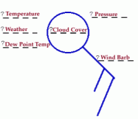
Because its fun. 850mb isotherms represent forecast thickness of cold air and the enevitable warm nose. That said. We were given permission.
-
 1
1
-
-
Insitu high pressure on snow pack just north of Maryland is gong to try and set up CAD. Will be short lived, but could give us our favorite ob, 35R-. Temps rise overnight Saturday.(mappy?) Sunday temps mid to upper sixties BWI.
-
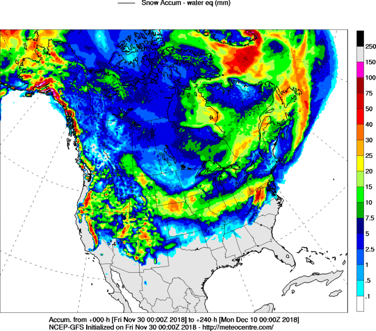
00z: d5 system is now religated to a slight risk SW- with vortmax passage. Surface low never phases except on GFS with 1 inch potential mainly south of BWI. Day 9 system, the good news is the Euro is not sending surface low to Pittsburgh. Looks alot like FV3 with significant snows along, and north and west of I-95 corridor. For your viewing pleasure the d5 depiction and snowfall liguid equalant map in mm.

-
18z GFS gets d5 system closer to coast. Precip fields not there yet. D9-10 storm, More better.

-
1 minute ago, poolz1 said:
Icon still likes the 5th... iirc, the icon was pretty firm with the follow up wave that became our Nov snow storm... What does it mean? Nothing probably.. Lol
Sent from my SAMSUNG-SM-G920A using Tapatalk
Better than being suppressed like canned ham...
-
If it can move that much in one run, it can move again. On to happy hour...
-
Just now, mappy said:
hahahaha i think that would be even worse.
234hr panel looks amazingly wet and moist and...
I think we just had a warm frontal passage....
-
1
-
 1
1
-
-
Suitable for framing...

-
-
3 minutes ago, midatlanticweather said:
To the bank or the trash can
")
Outstanding...
-
GFS few SW- with mid level energy d5. D10 storm is no longer heading toward Deluth MN. Heading towards Hatteras. Rather be on the north side in November.
-
16 minutes ago, Bob Chill said:
12z ICON is a perfect track/evolution for the 5th event. Best case scenario.
Looks a lot like Euro. Taps Atlantic moisture jus as it is pulling away.
-
5d tease looks much better on Euro. General 1-3 inches of snow. 10d still there, slight westward wobble.... Ingredients fo 5d showing up nicely on NAM. Cold air heading south and east behind departing Great lakes storm. Mid level energy coming out of southern Rockies. Old frontal boundary NE Gulf. Sweet...


-
6 minutes ago, Bob Chill said:
I can easily see how the storm on the 5th could work in our area. Not very likely but I wouldn't be surprised if more confluence starts showing up and the track moves east over the next few days.
Move the departing 50/50 south just 150 miles or so on this panel and it's snowing here...

That's why we are calling it the 5D tease....
-
If I had a dollar for every time I should have ignored myself.......
-
2
-
-
4 minutes ago, poolz1 said:
Long track storm at the end of an anomalous cold period? Pretty big piece of energy coming into the west coast for models to track...This same piece is evident by hr 90 on the GFS. D10 Euro has "that look." In a perfect world we would get a nice 1-3/2-4 appetizer on roughly the 5th and then 4-6 days later we get a real taste of an el nino winter storm.
Sounds good.
-
7 minutes ago, Chris78 said:
Euro looks like a snow to rain deal for the day 10 thing going off of the 24 hour TT maps. Hard to tell off of that though.
A lot better than 00z run.
-
1
-
-
Ye ol' Gulf Low... Puppy friendly...

-
Ref: 144-180hr system
12z data: GFS takes low west to buffalo. FV3 takes it south and out to sea, few SW-. CMS tries to bring it up the coast with 1-3 of snow. Hope springs eternal. Now let's see the mcdaddy....
-
Puppy killer...
-
More models to go. It ain't over till its over....


November/December Medium/Long Range Disco
in Mid Atlantic
Posted
You did. But you have the puppies....