cptcatz
-
Posts
1,077 -
Joined
-
Last visited
1 Follower

About cptcatz

-
Major Hurricane Melissa - 892mb - 185mph Jamaica landfall
cptcatz replied to GaWx's topic in Tropical Headquarters
114 kt FL winds recorded. Pushing cat 3 again. She just won't give up.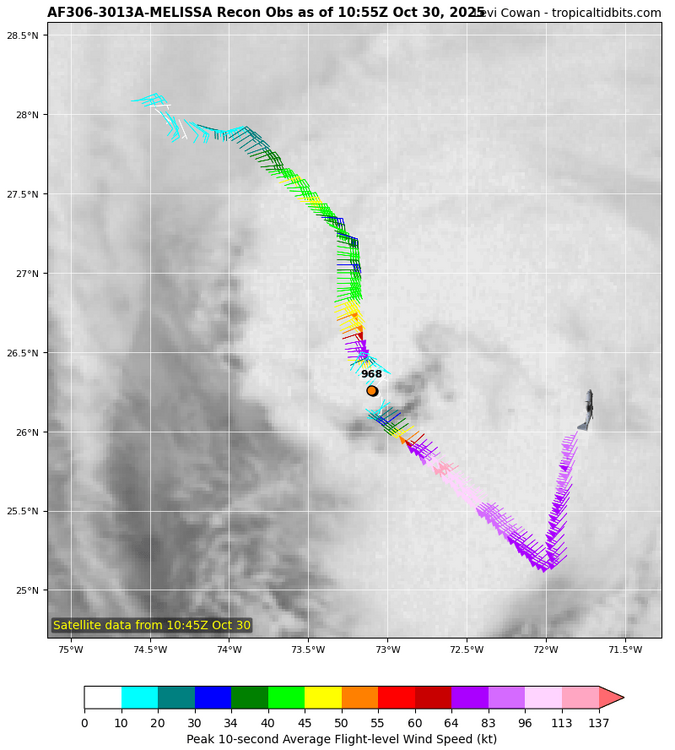
-
Major Hurricane Melissa - 892mb - 185mph Jamaica landfall
cptcatz replied to GaWx's topic in Tropical Headquarters
Looks like White House should have clear skies right now. Crawford may be just inside the eye right now. Hopefully Josh can have a few minutes of sunshine to go outside and document. -
Major Hurricane Melissa - 892mb - 185mph Jamaica landfall
cptcatz replied to GaWx's topic in Tropical Headquarters
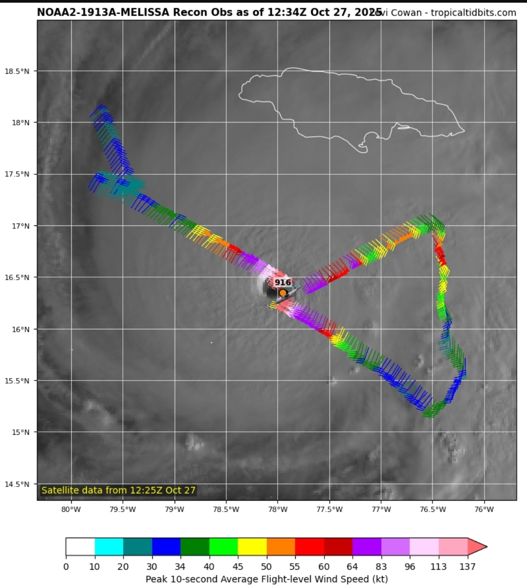
892, 185 mph. Landfall at this intensity would tie 1935 as strongest ever. -
Major Hurricane Melissa - 892mb - 185mph Jamaica landfall
cptcatz replied to GaWx's topic in Tropical Headquarters
The 1935 Labor Day Hurricane was the only Atlantic hurricane to make landfall below 900 mb, which hit at 892. This can very well be the strongest ever to make landfall. -
Major Hurricane Melissa - 892mb - 185mph Jamaica landfall
cptcatz replied to GaWx's topic in Tropical Headquarters
This will probably be up there with Dorian as his craziest eye. Anyways, recon about to go through the eye... -
Major Hurricane Melissa - 892mb - 185mph Jamaica landfall
cptcatz replied to GaWx's topic in Tropical Headquarters
And the 5am and 11pm -
Major Hurricane Melissa - 892mb - 185mph Jamaica landfall
cptcatz replied to GaWx's topic in Tropical Headquarters
Did that pass miss the center? -
Major Hurricane Melissa - 892mb - 185mph Jamaica landfall
cptcatz replied to GaWx's topic in Tropical Headquarters
Almost looks like a giant supercell you'd see in Oklahoma -
Major Hurricane Melissa - 892mb - 185mph Jamaica landfall
cptcatz replied to GaWx's topic in Tropical Headquarters
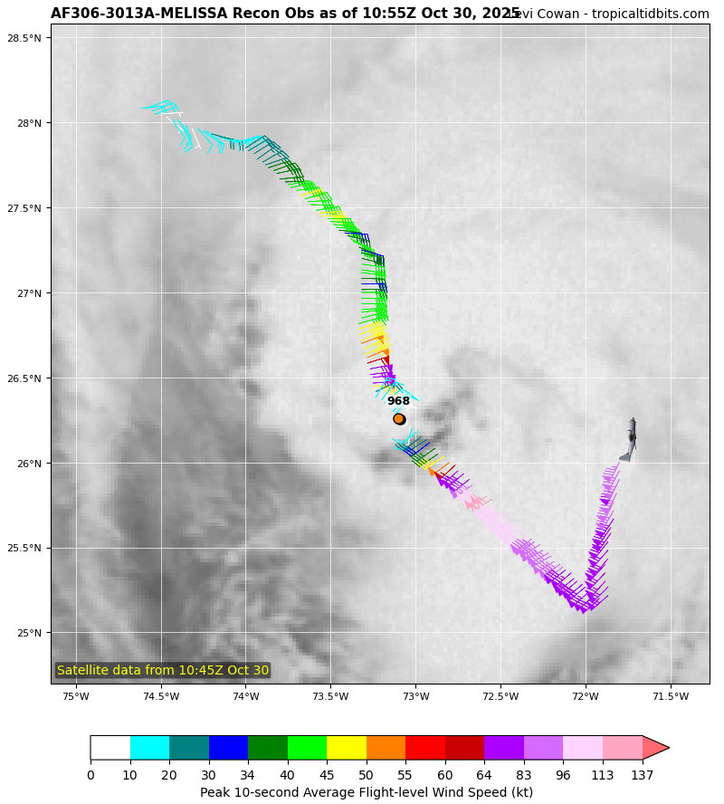
Looks like it's bottoming out with this latest pass. Pressure still around 910 and FL wind still at 156 kt. -
Major Hurricane Melissa - 892mb - 185mph Jamaica landfall
cptcatz replied to GaWx's topic in Tropical Headquarters
If an ERC happens soon, it could mean much worse impacts over bigger areas. Right now the storm is really small. If it turned north right now, eastern Jamaica wouldn't even get hurricane force winds and surge would be minimal outside of the small core.
-
Major Hurricane Melissa - 892mb - 185mph Jamaica landfall
cptcatz replied to GaWx's topic in Tropical Headquarters
Recon first pass: 155 kt FL winds, pressure 912, incredible dropsonde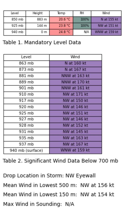
-
Major Hurricane Melissa - 892mb - 185mph Jamaica landfall
cptcatz replied to GaWx's topic in Tropical Headquarters
Except 11 hours late. It was not a 140 mph storm when they said it was at 5am. It strengthened into a 140 mph storm throughout the day. -
Major Hurricane Melissa - 892mb - 185mph Jamaica landfall
cptcatz replied to GaWx's topic in Tropical Headquarters
Looks like the plane is going home. Anyone know when the next flight is scheduled? -
Major Hurricane Melissa - 892mb - 185mph Jamaica landfall
cptcatz replied to GaWx's topic in Tropical Headquarters
I'm no expert on the socioeconomics of Jamaica but I would guess the tourist areas would fare better than the higher poverty areas of Kingston. Kingston getting the worse of it would likely cause a humanitarian crisis. -
Major Hurricane Melissa - 892mb - 185mph Jamaica landfall
cptcatz replied to GaWx's topic in Tropical Headquarters
Second pass: slightly higher winds in the NE eyewall but no change in pressure and no support of 140 mph winds.