Ian
-
Posts
43,737 -
Joined
-
Last visited
Content Type
Profiles
Blogs
Forums
American Weather
Media Demo
Store
Gallery
Everything posted by Ian
-

Devastating tornado strikes Joplin, Missouri
Ian replied to Hoosier's topic in Weather Forecasting and Discussion
too much need for instant gratification these days.. honestly it doesnt really matter if it was an ef4 or an ef5. -
Devastating tornado strikes Joplin, Missouri
Ian replied to Hoosier's topic in Weather Forecasting and Discussion
-
Devastating tornado strikes Joplin, Missouri
Ian replied to Hoosier's topic in Weather Forecasting and Discussion
they should be different based on timezone. -
Devastating tornado strikes Joplin, Missouri
Ian replied to Hoosier's topic in Weather Forecasting and Discussion
Hopefully like most early reports that sound similar.. Wrong. -
Historic Tornado Outbreak April 27, 2011
Ian replied to CUmet's topic in Weather Forecasting and Discussion
death toll past 1974 now http://www.google.com/hostednews/ap/article/ALeqM5gwJTIxeUWZizZWADgvTCGRhnRpiA?docId=5431c50bec974f00bf5d68f67d174739 -
Historic Tornado Outbreak April 27, 2011
Ian replied to CUmet's topic in Weather Forecasting and Discussion
thx. might use on WaPo. -
Historic Tornado Outbreak April 27, 2011
Ian replied to CUmet's topic in Weather Forecasting and Discussion
do u have a source for this? -
Historic Tornado Outbreak April 27, 2011
Ian replied to CUmet's topic in Weather Forecasting and Discussion
It is rare but seemingly less rare these days and likely less rare going forward as population density increases. It doesn't really matter--it's terrible whether it's 200 or 1000. Was mostly just pointing out these abnormally high casualty incidents often follow a similar pattern of speculation. -
Historic Tornado Outbreak April 27, 2011
Ian replied to CUmet's topic in Weather Forecasting and Discussion
not relevant. people thought there were 20-30k dead after Katrina. I remember stories of bodies filling beaches etc.. none of it ended up true. the japan quake people were saying "oh, it could be 100k dead". it's possible there are still more big caches of bodies to find but even as widespread as the damage is, it's not as widespread as a giant earthquake or something. it won't take as long to come to a tally other than people who are really badly injured dying from their injuries etc. -
Historic Tornado Outbreak April 27, 2011
Ian replied to CUmet's topic in Weather Forecasting and Discussion
one thing that's pretty common in these high casualty events is there are some who think the toll will end up 10x higher than it does. -
Historic Tornado Outbreak April 27, 2011
Ian replied to CUmet's topic in Weather Forecasting and Discussion
exactly.. it's kind of a silly idea that you'd be up in arms that you were "forced" to have a ~3,000 additional expense on a new home that you'd barely even notice in the course of financing options etc. though arguably your odds of taking a direct hit from a tornado even in tornado zones is less than taking damage from a hurricane or earthquake in places that have them. -
Historic Tornado Outbreak April 27, 2011
Ian replied to CUmet's topic in Weather Forecasting and Discussion
gotta take over 4 more states since you only have 30? -
Historic Tornado Outbreak April 27, 2011
Ian replied to CUmet's topic in Weather Forecasting and Discussion
Is AL not part of the southeast? -
Historic Tornado Outbreak April 27, 2011
Ian replied to CUmet's topic in Weather Forecasting and Discussion
huh? that's what photographers do. photographers have won awards for taking pictures of people being killed in front of them. -
Ahh yes I was confused on which image. I think I saved that whole group but just posted one frame.
-
heres the whole storm loop i think the nam loops in here are ones i made.
-

-
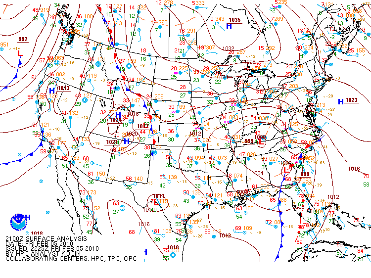
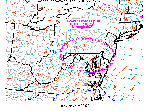
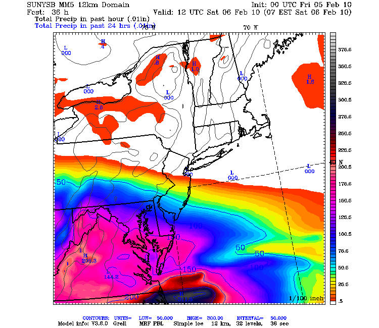
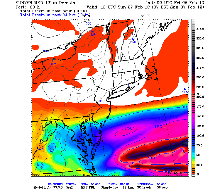
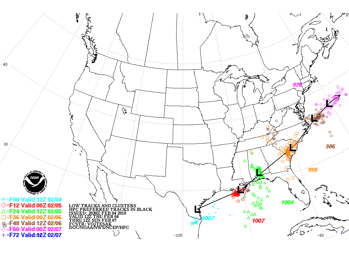
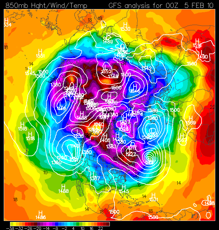
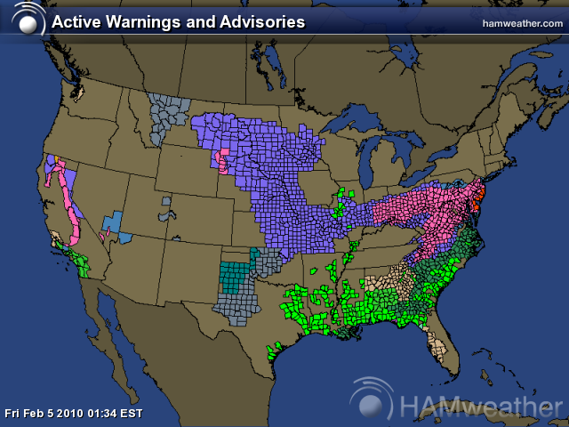
MESOSCALE DISCUSSION 0104 NWS STORM PREDICTION CENTER NORMAN OK 0558 PM CST FRI FEB 05 2010 AREAS AFFECTED...SRN PA...NERN WV...NRN VA...MUCH OF MD AND DE...AND SRN NJ CONCERNING...HEAVY SNOW VALID 052358Z - 060400Z INTENSIFYING SNOWFALL RATES UP TO 3 IN/HR ARE PROBABLE THROUGH 06Z ACROSS SRN PA...NERN WV...NRN VA...MUCH OF MD/DE AND SRN NJ. EJECTING UPPER S/W TROUGH OBSERVED IN WATER VAPOR IMAGERY MOVING NE ACROSS THE TN VALLEY AND SERN STATES IS FORECAST TO PROGRESS INTO THE MID ATLANTIC REGION THROUGH 06Z...WITH SECONDARY CYCLOGENESIS UNDERWAY /PER STRONG SURFACE PRESSURE FALLS OBSERVED IN RECENT OBSERVATIONS/ ALONG COASTAL FRONT OVER THE CAROLINAS. AREA VWP DATA ALONG WITH SHORT TERM MODEL GUIDANCE INDICATES THE PRESENCE OF A STRONG SLY 850-700 MB JET NOSING INTO VA. THIS FEATURE IS FORECAST TO SLIDE EWD DURING THE NIGHT...BECOMING POSITIONED OVER SRN NJ BY 06Z. IT WILL BE ACCOMPANIED BY INTENSE CONVERGENCE...WAA...AND DEEP LAYERED FRONTOGENESIS FAVORING STRONG UVV/S WITHIN A STEEP 5-8 KM LAPSE RATE ENVIRONMENT...WITH SNOWFALL RATES UP TO 3 IN/HR. FORECAST SOUNDINGS ACROSS THE REGION INDICATE THERMODYNAMIC PROFILES OVER THE LOWEST 2-3 KM WILL RESIDE BETWEEN 0 TO -5 DEG C...WHICH SUGGESTS THAT FALLING SNOW WILL BE HEAVY/WET DUE TO SIGNIFICANT AGGREGATION. IN ADDITION...AS SURFACE CYCLONE DEEPENS ALONG THE NC COAST...NELY WINDS WILL LIKELY STRENGTHEN THROUGH 06Z...WITH GUSTS AS HIGH AS 35 MPH. THIS WOULD FAVOR VISIBILITY REDUCTIONS TO A QUARTER MILE WITH BLOWING AND DRIFTING SNOW. ..GARNER.. 02/05/2010 ...NOTICE... SPC WINTER WEATHER MESOSCALE DISCUSSIONS WILL BE ISSUED ON A SCHEDULED BASIS FROM DECEMBER 1 THROUGH FEBRUARY 28...FOUR TIMES A DAY...AROUND 00 UTC...06 UTC...12 UTC...AND 18 UTC FOR SIGNIFICANT SHORT RANGE WINTER WEATHER EVENTS. ATTN...WFO...PHI...AKQ...CTP...LWX...PBZ... LAT...LON 39877971 40457918 40817807 40777663 40217490 39487439 38797487 38427571 38347703 38757894 39277953 39877971
-
-
-
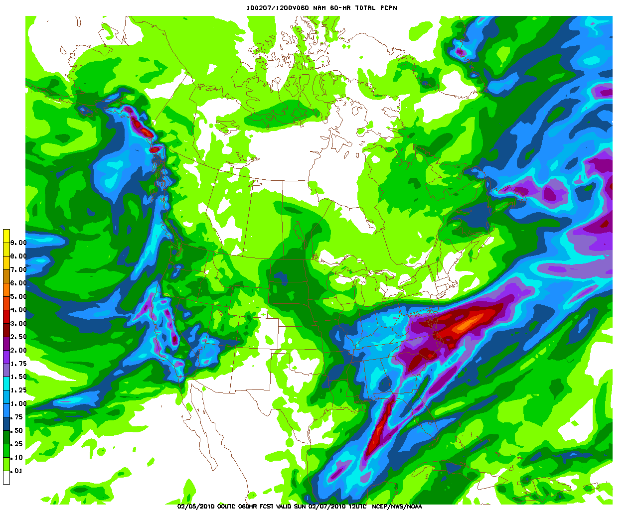
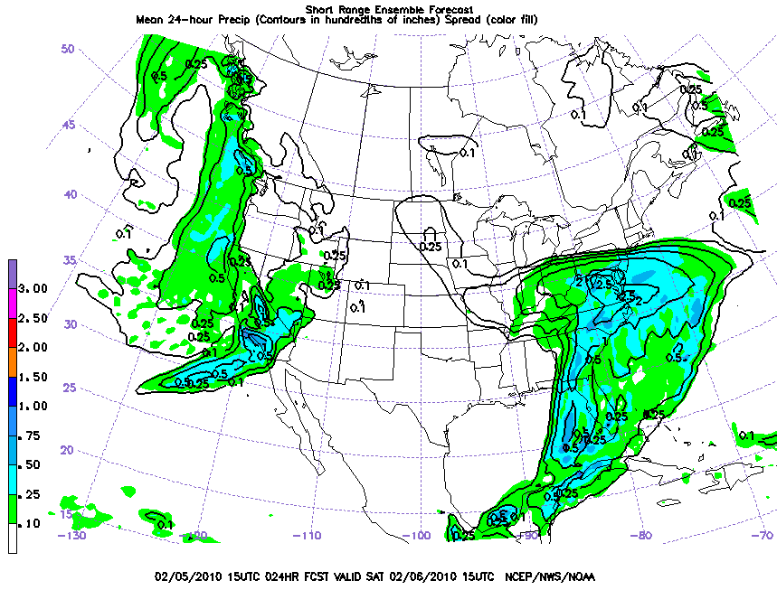
2/5 15z SREF -- 24 and 12 hr qpf 2/5 12z NMM
-
MESOSCALE DISCUSSION 0098 NWS STORM PREDICTION CENTER NORMAN OK 1045 AM CST FRI FEB 05 2010 AREAS AFFECTED...ERN WV/SRN PA/NRN VA/MD/DE CONCERNING...HEAVY SNOW VALID 051645Z - 052045Z A SIGNIFICANT WINTER STORM CONTINUES TO DEVELOP OVER PORTIONS OF THE MID ATLANTIC. SNOWFALL RATES WILL QUICKLY INCREASE FROM 18-00Z WITH INCH AN HOUR RATES BECOMING COMMON AND LOCALIZED RATES OF 2 INCHES AN HOUR. RATES WILL FURTHER INCREASE BY 00Z...WITH 2-3 INCH AN HOUR RATES AND RAPID ACCUMULATIONS THEREAFTER. DRY LOW LEVELS REFLECTED ON 12Z SOUNDINGS ARE QUICKLY SATURATING THIS MORNING...EVIDENCED BY RAPID DEW POINT INCREASES /2-3 DEGREES PER HOUR VIA RECENT OBS/ AND TEMPERATURES SLOWLY DECREASING AS EVAPORATIVE COOLING COMMENCES. CURRENT VAD WIND PROFILE DATA ACROSS THE CAROLINAS/SWRN VA ARE SHOWING INTENSE WARM ADVECTION PROFILES WITH VERY STRONG VEERING WINDS WITH HEIGHT...WHICH WILL FURTHER SUPPORT DEEP LAYER SATURATION AS SIGNIFICANT MOISTURE /PWATS NEAR 150 TO 200 PERCENT OF NORMAL PER 12Z RAOBS/ ADVECTS NEWD. WEDGE FRONT AND SUBTLE EFFECTS OF THE INITIAL EVAPORATIVE COOLING WILL SUPPORT P-TYPE OF ALL SNOW AS TEMPERATURES AT THE SURFACE REMAIN SUBFREEZING. AS THE UPPER LOW CONTINUES TO SHIFT EWD WITH TIME...UPPER DYNAMICS WILL BECOME INCREASINGLY FAVORABLE FOR AN INTENSIFICATION IN SNOWFALL RATES AS VERTICAL MOTION INCREASES IN CONJUNCTION WITH STRONG UPPER DIVERGENCE. LIGHT TO MODERATE SNOW IS ALREADY BEING REPORTED...AND WILL LIKELY TRANSITION TO HEAVY SNOW BY AFTERNOON. HEIGHT FALLS ARE INFLUENCING SURFACE PRESSURE FALLS NEAR ERN KY/WRN VA OF 1 MB/HR OR GREATER...AND IN ERN NC NEAR 1.5 MB/HR AS CYCLOGENESIS OCCURS. THE PRESSURE GRADIENT WILL CONTINUE TO INCREASE THROUGH THE DAY ESPECIALLY IN VA/COASTAL AREAS AS A SURFACE LOW QUICKLY DEEPENS AND MOVES UP THE COAST...CAUSING NEAR BLIZZARD-LIKE CONDITIONS IN BLOWING SNOW. AS THIS OCCURS...ADDITIONAL ENHANCEMENT WILL BE LIKELY ALONG UPSLOPE AREAS OF THE BLUE RIDGE AND APPALACHIAN MOUNTAINS...AND ALONG THE IMMEDIATE COAST AS MOISTURE FLUX OCCURS OVER THE OCEAN THEN SHIFTS INLAND NEAR THE DC/BALTIMORE METROPLEX IN NELY/ELY LOW LEVEL FLOW. ..HURLBUT.. 02/05/2010
-
-
0z GFS 2/5
-
0z NAM 2/5