

Holston_River_Rambler
-
Posts
5,560 -
Joined
-
Last visited
Content Type
Profiles
Blogs
Forums
American Weather
Media Demo
Store
Gallery
Posts posted by Holston_River_Rambler
-
-
Random severe storm rolling N and NW in Monroe county this PM. Can see the towering clouds from my place in Morgan county.
-
Sorry man.
-
14 hours ago, John1122 said:
I'm honestly not sure if my roof is going to make it. My back porch roof is probably going to be needing replaced for sure. It calmed down some between 8 and 10 but it's ramped back up to full blast now. An 80 foot pine is down in my lower yard already. I'm most stunned my power is on. I guess the last big wind event may have cleaned out all the loose trees.
How did everything turn out?
-
Strat PV looks like it may get obliterated in just over a week. Last one didn’t work out a few weeks ago, but this one looks stronger.
Masiello is saying that this has the potential to be one of the strongest wave one events on record in March.
impacts, if any, would likely be towards the end of March.
-
 2
2
-
-
I made a new historic severe wx thread.
-
3
-
 1
1
-
-
My old thread got archived, so I made a new one.
-
3
-
 1
1
-
-
12z Euro has something around March 8. I think this is the same system models have been seeing off and on per the above posts.
-
 1
1
-
-
On 2/23/2025 at 1:57 PM, Carvers Gap said:
I would recommend creating a separate, historical thread for severe weather. This thread was created for historic winter weather events. I have no issues at all w/ Powell's post, but a separate thread would be pretty cool, and is probably needed.
I made one years ago. Not sure where it went.
-
1
-
-
Yeah, just saw the Euro and thought that looked ideal for y’all severe folks next Tuesday evening. Hopefully it will QLCSify by the time it gets to the plateau, if it happens as the 12z Euro depicted.
-
2
-
-
Almost looks like there is a little leeside low forming in upstate SC
-
5
-
-
A live look out my window:

-
6
-
-
Ended up with about 1.5" total so far.
-
6
-
-
Much vaunted late February sun angle has done exactly 0 to melt anything except on the roads.
-
4
-
-
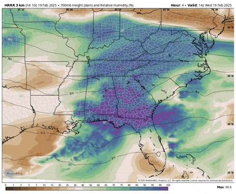
Here's how that looks on the HRRR, (using COD site since the blues are bluer there)
-
1
-
-
5 minutes ago, nrgjeff said:
However if enough mid-level moisture hangs around, and surface temps stay cold, maybe later today.
Yeah, I was just looking at the HRRR and RAP and it almost looks like this system us getting some higher (more elevated)-than-usual moisture trapped on our side of the Apps and some orographic lift is able to take advantage of that in areas that usually don't do well with the typical upslope.
-
1
-
 1
1
-
-
Looks like MRX finally filled in the WWAs over the southern valley.
Looks like they pulled the trigger at around 5:30 am.
-
1
-
 3
3
-
-
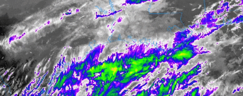
Pretty cold cloud tops over east TN with some back building over Mississippi and western AL:

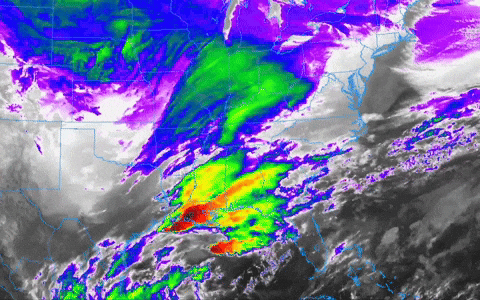
That big upper low is just over the Dakotas is just pushing it all through a little too fast.
-
2
-
-
1/2" here.
-
2
-
-
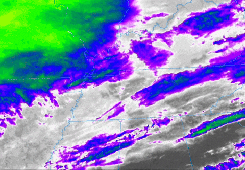
oooo we have a mesoscale disco:

 Mesoscale Discussion 0116
   NWS Storm Prediction Center Norman OK
   0601 PM CST Tue Feb 18 2025

   Areas affected...Northeastern Arkansas...Southeastern
   Missouri...Western Tennessee...Western Kentucky...Southern Illinois

   Concerning...Heavy snow

   Valid 190001Z - 190300Z

   SUMMARY...Snowfall rates will gradually increase across portions of
   western Kentucky and western Tennessee through the evening. Rates
   will decrease through time, though some moderate to heavy snowfall
   rates up to 1"/hr will be possible in heavier bands.

   DISCUSSION...Radar analysis shows the gradual shift of snowfall into
   portions of western Kentucky and Tennessee this evening. Moderate to
   heavy snowfall is ongoing across southeastern Missouri into southern
   Illinois, where a persistent heavy band extends, driven by 700-850
   mb frontogenesis and isentropic ascent. This enhancement will
   gradually shift eastward through time, with potential for a few
   heavier bands with occasional 1"/hr rates. HREF ensemble guidance
   shows a down trend in rates overall through the evening, with a
   transition to mostly light snow for portions of western Tennessee.
   Confidence is highest in potential for better rates across
   northwestern Kentucky into southern Illinois.

   ..Thornton.. 02/19/2025
-
8
-
1
-
-
Saw a lightning strike and some convective clouds as the sun was setting upstream:

-
6
-
-
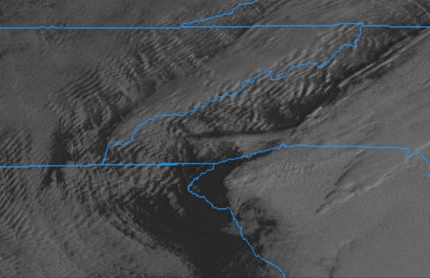
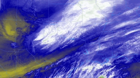
A few satellite and radar obs. for now:
Looks to me like convection parallel to the Gulf coast thingy is happening.
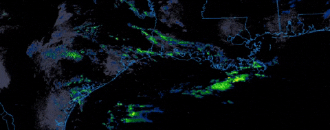
Note the feature over SE/ South central Texas. Looks like a front focusing the precip. there and south of the LA coast.
Also evident on Long wave IR band:
No clue what this feature is in west TN (maybe lower/ mid level moisture/ WAA impacting higher cloud temps somehow?) but it looks cool on IR imagery.

Dry air trying to overcome near Memphis:
Deep Gulf connection seems shut off for now, so we wait and see what the actual shortwave does as it moves east. Still looks near TX/ NM border to me
-
2
-
3
-
-
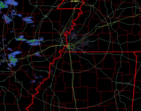
Pretty good radar echoes SW of Memphis right now but you can also see the virga halo around the radar site.
-
5
-
-
Rhea county has a Cold weather advisory now!
-
2
-
-
9 minutes ago, John1122 said:
I guess they are not going with the Euro.
Sun angle is much lower with JKL’s latitude.
-
2
-
12
-
TV Severe Weather2025-?
in Tennessee Valley
Posted
I was actually out of town for that. Just a lot of trees down in Frozen Head and some moderate flooding IMBY.