

WinterFire
-
Posts
82 -
Joined
-
Last visited
Content Type
Profiles
Blogs
Forums
American Weather
Media Demo
Store
Gallery
Posts posted by WinterFire
-
-
14 minutes ago, Ji said:
Then someone should have just said that there be no winter till January 25.
You can’t have a mid month warmup when it’s too warm to snow in the early month and the previous month
Absurd.Holy shit are you serious? So many people said this, you just cherry-picked the data you wanted to look at to get the results you wanted. Moron.
-
 1
1
-
 1
1
-
-
4 hours ago, WEATHER53 said:
Agreed
Its bad when they are wrong. It’s Worse to say they weren’t
It would be great if you would stop lying, both about what the models have said and about what other people have said. It’s sad, especially when it’s so easy to see that you’re making things up.
-
1
-
 1
1
-
-
https://x.com/webberweather/status/1740164865161924685?s=46
Fwiw even Webb isn’t canceling winter (and tbh he’s been more bullish on this winter than he’s given credit for, he just likes to troll the snow weenies on Twitter)
-
1
-
-
1 hour ago, WEATHER53 said:
Let’s get some cold and snow in here. So far the projection from Nov and early Dec of change on 12/15, then Christmas, then most assuredly 12/28 or 29 did not occur. We’ve got until 1/10 or we are sunk. I take No pleasure in sunk Low pressures and clippers gotta synchronized up . Noll going nuts about the umpteenth SSW which is perpetually just about to happen when things are not going well. MJO-Well Who Knows.
Arguing with a toddler is pointless; best case scenario is you win an argument with a toddler. So I say this not to argue with this specific individual but for the rest of the folks reading the thread: this is emphatically not what is happening.
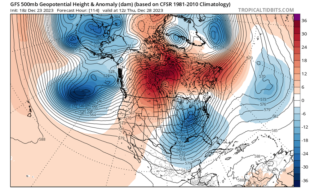
Reference the images a few days ago in my exchange with WW—the models advertised a pattern change for late December and a pattern change is indeed coming. Regardless of someone’s feelings, facts are facts and all of this data is freely available on sites like TT and pivotal; anyone can feel free to scroll back 10-15 days and see how the GEFS or EPS envisioned the atmosphere for this time period. The long-range models are pretty good at figuring out long wave patterns two weeks out, actually!
-
4
-
 1
1
-
1
-
-
33 minutes ago, psuhoffman said:
Pattern analogs are useless right now. They’re spitting out some incredibly snowy periods (1996,2010) and some years that had almost no snow (2002, 1981). Subtle differences can tilt this either way.
Our quest stands upon the edge of a knife. Stray but a little and it will fall, to the ruin of all…
Yet hope remains while all the company is true.
-
1
-
-
17 minutes ago, WEATHER53 said:
Great. Thanks for update
Any time, happy to help.
-
18 minutes ago, WEATHER53 said:
How much more delayed are we now?
Pattern change still on track for the next couple days, so not even a little bit.
-
1
-
-
11 minutes ago, Weather Will said:
Last one.
From Dec. 16th
Still seeing consistent indications on the ens means for a coastal storm in the 27-29th window. Last 2 runs of the GEFS have a pretty decent signal for frozen in the MA, esp inland with temps expected to be marginal.
I am not a meteorologist, but I am a lawyer, I don't make up facts.I’m not saying you are making things up, and I’m definitely not trying to suggest that there weren’t people on this board who got excited about snow potential next week. Actually, I think this was a very helpful exchange for me to see just how much distance there can be between a correct (assuming the next few days don’t see a pattern collapse) model forecast and the ways in which we interpret it, especially on this board.
Anyway, I’m not trying to come for you, and I’m sorry it’s been piling on to your specific post. You certainly are not the only one who has mentioned can-kicking, and I think you’ve at least been sincere.
Other posters, on the other hand…
-
3 minutes ago, Weather Will said:
Last one.
Dec. 16th
Still seeing consistent indications on the ens means for a coastal storm in the 27-29th window. Last 2 runs of the GEFS have a pretty decent signal for frozen in the MA, esp inland with temps expected to be marginal.
And there is indeed a coastal at this time frame, though I will grant that temps are worse than marginal, even inland. Which should have been anticipated given the airmass we are working to scour out.
-
1
-
-
 This is the same time from today’s 18z GFS. Not a lot of daylight between them, I don’t think?
-
1
-
1
-
-
12 minutes ago, Weather Will said:
I don't have time to go back and look at the forum from about two weeks ago, but modeling was hinting then about storms after Christmas. Now we are talking the week after NYs, or two weeks later. So I understand the frustration of some about the next 10 days fizzling out, hopefully that will not continue.
It might be worth looking again, because no one seriously talked about anything other than a pattern change coming around or just after Christmas. That remains on track to happen as it has been discussed since the 12th or 13th. Some op runs (and even some ensemble runs hinted) at a shot potential next week, but that was never terribly likely or realistic.
What has happened instead is that people read this thread and hone in on the rip-and-read blue pixels that less knowledgeable posters got excited for and confused that with an accurate analysis of model predictions. The can hasn’t been kicked, at least not on the models. The only reason that some people think that is because they are confusing a specific storm that showed up once on guidance with a set-in-stone prediction.
The can is not being kicked, the pattern is on track to change as forecast weeks ago. Cold air is moving in and appears to be more stable after the new year…as predicted by weeklies earlier this month. Don’t confuse weenie expectations with model forecasts.
-
5
-
-
32 minutes ago, mattie g said:
I have plenty of folks on ignore, even if I do try to be mindful of not creating my own personal echo chamber.
I do wish the board software could hide the quoted posts by those on ignore though. ¯\_(ツ)_/¯
Hard agree. I love ignore, it is a beautiful function, but it is completely ineffective when everyone quotes and responds to the people I’m trying desperately to ignore lol
-
1
-
-
Jesus christ the long range thread is unreadable today…and that’s with the worst offenders on ignore, I don’t know how you people do it, reading every one of Ji’s and Eskimo Joe’s absolute garbage posts…
-
1
-
1
-
4
-
-
1 hour ago, BristowWx said:
It’s hard to be overly optimistic when the 540 line at 174 is no where in the US. Even Maine. It’s the op sure but that doesn’t foster much confidence.
This is something I’ve been wondering about as well, not just today. It’s seemed like even with the better looks we’ve seen in previous weeks, the 540 line has stayed pretty far north. Not panicking/trying to deb but maybe someone with more knowledge could explain why that’s not a flag? Or just what it means in aggregate.
-
13 minutes ago, WesternFringe said:
Wait, I thought December was already declared a torch and a sea of warm based off of the weeklies a couple weeks ago!?!
In reality, so far December has produced snow for many in the sub-forum and it feels pretty cold with lows in the low 20s and highs in the 40s here this week with more of the same on the way over the next week plus.
Fwiw, DCA is running 1.8 degrees above normal and IAD is running 3.9 degrees above normal. So while it’s been cooler than previous torch Decembers, it’s been solidly AN despite what it may seem like.
-
2
-
1
-
-
11 minutes ago, stormy said:
You are obviously a neophyte. Since you profess to be an expert, challenge the ECMWF . What are your QP predictions for the next 15 days??? I don't want a bunch of crap. I want detailed QP for the entire region for the next 15 days! Come on , give it to me. You can't' , so chill out.
Ideally, reasonable people express reasonable ideas on this site. Unreasonable crap needs to die. More and more supporters are getting disillusioned.
Dude you posted the D15 Euro control. That is an incredibly unserious thing to take verbatim and it is *deeply* silly to die on this hill…
-
1
-
1
-
-
1 hour ago, Stormchaserchuck1 said:
Natural Gas dropping from 3.6 to 2.9 lately.. Under 3.0 implies a +NAO Winter.
.thumb.png.4c673527cf7ad5c2ad9dd3ced026602a.png)
No, it implies that natural gas day traders think there will be a +NAO this winter. Commodities trading has absolutely no bearing on how our atmosphere works, on a seasonal scale.
-
2
-
-
1 hour ago, CAPE said:
We rarely see wall to wall cold in Dec in these parts regardless of Enso state.
He’s also dead wrong…Dec 2018, 2015, and 2014 were snowless at DCA (though we all remember how achingly close 2018 was), and all were warmer than average, as was 2004. 2002 and 2009 were the aberrations for Dec Nino climo.
-
9 hours ago, yoda said:
Looks like upper 90s to 100 degrees returns next week per morning AFD from LWX
For the end of the week into next weekend, the pattern turns hotter
and dry. A very strong 600 dm upper-level ridge takes shape over the
Midwest and Great Lakes regions during this time. It actually
appears as though the air mass will be much drier with this bout of
heat with the Bermuda High not in place this go around as a cold
front pushes through on Friday. Friday and Saturday will be closer
to climo, with upper 80s to low 90s expected. However, by Sunday
into early next week, expect temperatures to climb into the upper
90s.
FWIW, that was pretty quickly removed in the next update. The big heat looks to stay focused in the Midwest, as it has been. But the cool-down the long range GFS wants to bring us…
…is definitely not going to happen, but fun to look at
-
If we can’t discuss why long range patterns are progressing the way they are being modeled to progress in the literal long range thread, what the actual fuck is the point of a long range thread?
1 hour ago, North Balti Zen said:that discussion has been had and is being had in a thread on this sub-forum. Read there. Good discussion there.
-
1
-
-
52 minutes ago, Ji said:
Hmmm

Hmmmmm not sure you’re the one to be making the point you think you’re making here chief.
-
7 minutes ago, Ralph Wiggum said:
You mean the "atmospheric river"? That is what the media has dubbed the stj aimed at CA. Bomb cyclones, atmospheric rivers, polar vortex mania....no wonder people don't want to watch the mews anymore.
The term atmospheric river was coined by Zhu and Newell at MIT in 1998: https://journals.ametsoc.org/view/journals/mwre/126/3/1520-0493_1998_126_0725_apafmf_2.0.co_2.xml The polar vortex and bomb cyclones have been discussed in academic contexts for decades. Just because something is new to you doesn’t mean it’s new, and the media using correct terminology in public communication is a good thing even when these terms are unfamiliar to you.
-
11
-
-
9 minutes ago, psuhoffman said:
Unfortunately what he did was kinda smart. I think many wanted to be optimistic (myself included) and sided with a forecast of a closer to median snowfall winter. But the analogs and stats said there was pretty close to a 45% chance of a god awful single digits season, 45% of a closer to median bad but not horrible season and like 10% or less of a truly snowy season. So why not do what he did and stick out there. Even if we get closer to the better outcome we’re very likely to end below avg so he won’t bust too bad. And if this goes the way of some of the awful analogs he gets to crow and look like a genius. Smart play.
I don’t think I’d agree that his forecast will be spot on—more like he’ll have the snowfall right but for the wrong reason. He predicted a warmer than average December—it won’t be. I do think if we crap the bed in January, it’ll be because of warmer than average temps—which he specifically went against. So yeah maybe he’ll get Feb right, and maybe a full Jan and Feb torch will land us in a top-5 warmest winter ever (again, his prediction), but getting the top line right while completely missing the pattern evolution doesn’t mean he had a successful seasonal forecast.
-
2
-
-
11 minutes ago, psuhoffman said:
5) You keep focusing on what the change is per year. Over time very small changes add up to be significant.
This part. I’m not sure if you’re meaning to imply this, @WesternFringe, but focusing on an annual average change of -.06” makes it seem like your argument is that DC winters have only seen a decrease of .06” from 1941 to today. But that’s not what a slope of -.06 implies—rather, it’s indicating that the annual snowfall from 1941 has decreased by a total of something like 4.5”. Which is noticeable, I’d argue. So yes, between last year and this year, most people would not notice a decrease of .06”. But over the last 30 years, we do notice a decrease of nearly 2” (which incidentally matches relatively closely with the 30 year average in the 00s of 15.4”/year compared to the 20s average of 13.9”/year).

.png.c470f5f866db75d0a3c6a1df144bbb47.png)
Jan Medium/Long Range Disco: Winter is coming
in Mid Atlantic
Posted
Yeah except that the monthlies—that were discussed *extensively* here and elsewhere through the end of November—were pretty much uniform in showing a torch December, transitional January, and a killer February. That’s what all the guidance showed, that’s what most experts discussed, and that’s where you and so many other people would have landed if you weren’t intent on wishcasting a Modoki/CP-based Nino that never existed.