

PB COLTS NECK NJ
-
Posts
458 -
Joined
-
Last visited
Content Type
Profiles
Blogs
Forums
American Weather
Media Demo
Store
Gallery
Posts posted by PB COLTS NECK NJ
-
-
6 minutes ago, snowman19 said:
A big part of the problem was the ridiculous analogs being peddled around back in September, October and November. Some folks were calling for wall to wall winter from November through March and it backfired horribly
Most had a warm Dec.
Jan / Feb/ 1st half of March winter
-
You would be in the Null p by day 9 if this is correct , but keep in mind you had a Strat Warm.
It is going to be a player in the pattern , this is not December.
-
 2
2
-
-
19 minutes ago, bluewave said:
The whole winter pattern so far has been really MJO driven. So small changes in the day 6-10 forecast have made post day 10 guidance even more unreliable than usual. The MJO becoming more active in recent years has added a new wild card to our winter forecasts.
This has done very well
The MJO has been the driver but getting stuck in p5 for 2 weeks pre strat warm is a lot different than a muted 4- 5 with a vortex over H/B and rolling SE.
I saw the east risk last week for this weekends system and that was right ,but I do see the W risk here with the WAR sitting out there.
I just want to get closer , I think there`s a lot of good stuff in front of us tho.
-
1
-
-
3 minutes ago, bluewave said:
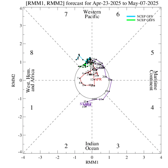
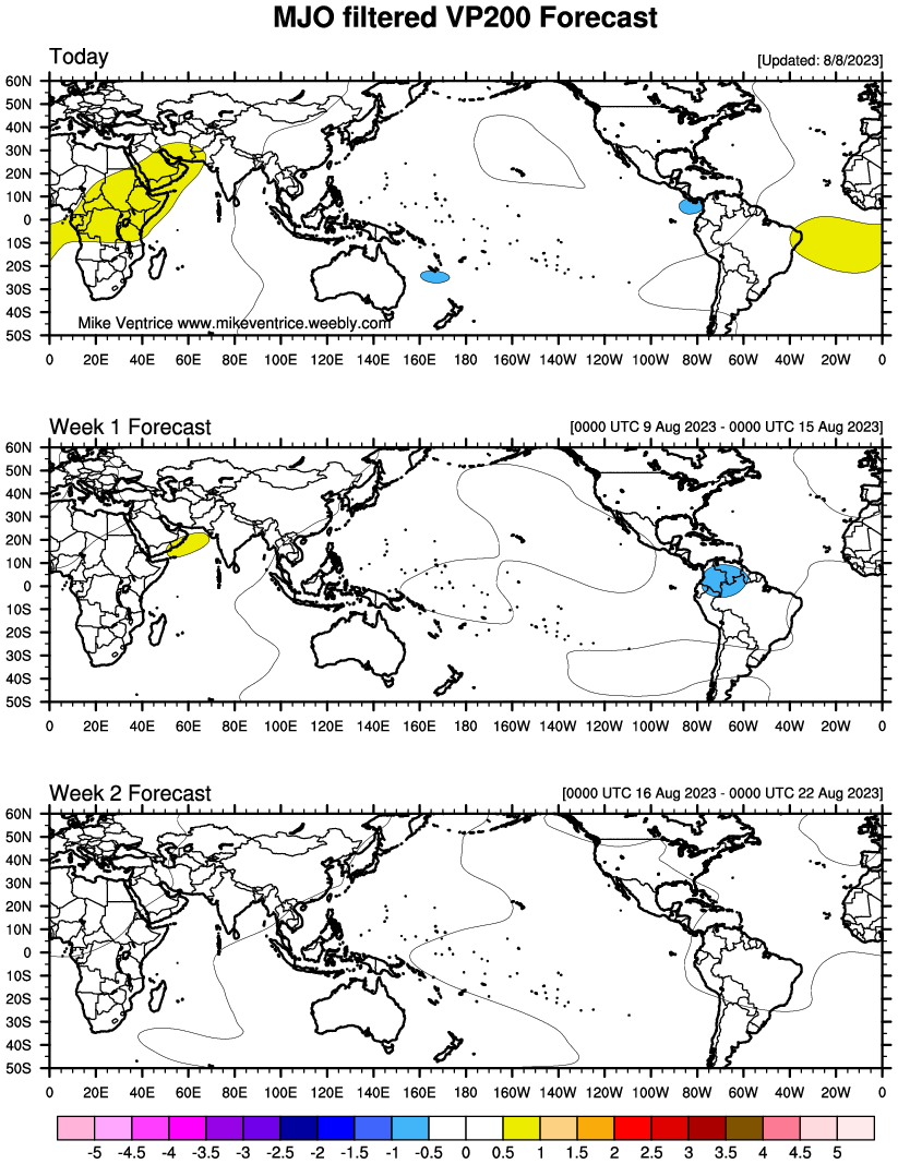
Only the GFS RIMM plots have been awful as the Euro has done much better. Remember the GFS going off the charts around Christmas.? Even the GFS VP charts are showing forcing over the IO and Maritime Continent going forward.
That 5SD was silly. We may head across towards 5 , but if you look at the RIMM plots , you are closer to a sub 1 SD p4 and by that with time the lag out of the null phase which may be allowing other drivers to be in charge at d9.
We can always cut , and although I posted the redevelopment of the EPS , there is a primary that goes into the OHV 1st .
If that gets N of 40 then the coast is toast.
At 9 days I need to see if the - EPO is real in front of it before I make a forecast.
-
Always a chance that these are wrong , but you have to use the ensembles 9 days out

-
Just now, NEG NAO said:
I think "patience" has been the most used word in this forum the last month or so - "bust" might become the second
A completely toasted December will do that.
-
Careful with the RIMM plots they have been awful over the last few weeks , secondly a very muted p of the MJO may be fighting the effects of a S/W with the vortex moving SE out of HB at the time.
The EPS isn`t a cutter , it take a center to the OHV and redevelops it off the Delmarva , the GEFS mean if off to your east and is cold.
It is 9 days away and I would seriously wait a few days before anyone jumps.
The winter has sckkkd so missing another one would hurt I get it , but patience with this one.
-
2 hours ago, bluewave said:
Looks like the MJO going back toward phase 5 pumps the WAR just enough ahead of the Jan 20th storm.


You`re not in p5 in 9 days.
-
23 minutes ago, NEG NAO said:
This look like a big rainstorm cutter next weekend ? Not that I trust the American models during the shutdown BUT going forward the -AO + PNA pattern developing would argue against cutters for a while

The pattern flip started today ( the 10th has been opined on in here and the source region has changed , so that looks like it will work). As I said last week the risk for this weekends system was East of us not West.
I agree with the above , that`s not cutting. The 2 dates I posted in here 7 days ago were the 13th and 20th - the 13th heads off to our S and the confluence and placement of the TPV in Canada wins out.
But that was always an option.
We aren`t getting a big cutter and that TPV is on the move as - 50 air is showing up in E Canada in the L/R.
We are heading into a very cold period ( colder the deeper we go ) . But a " pattern change " doesn`t mean it has to snow. BN`s have now returning and the 19 - 23 period is the next favorable period for a system in the area.
But I would caution that not every good pattern produces snow , cold and dry is always an option , however one thing is evident warm and wet are over for the time being.
-
4
-
-
The EPS just lept into the GEFS camp...
-
1
-
-
The Euro took a big step towards the GFS and away from the UKIE
-
2
-
-
4 hours ago, TriPol said:
So the GFS caved to the EURO?
See the 12z GEFS
-
1
-
-
13 minutes ago, bluewave said:
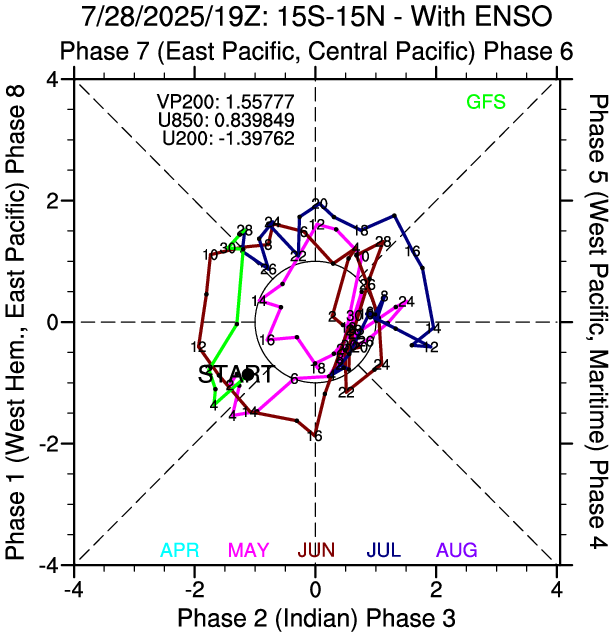
The CPC charts have it in phase 8 today. But all models quickly take it to the circle by the end of the week. So it’s not enough time to change the fast Pacific flow while we get the trough back into the East. Probably not a good time to get invested in any specific storms right now.
These have been preforming the best
-
 1
1
-
-
The pattern change around the 10th is on target. Accumulating snow is likely for some Sun/ Mon .
Not sure how much but I believe you will see some snow that is able to make it out of the S branch into very cold air which should accumulate.
If you phase ( then it`s more snow ) , but right now I think there will be enough out of the S branch alone to make it this far N.
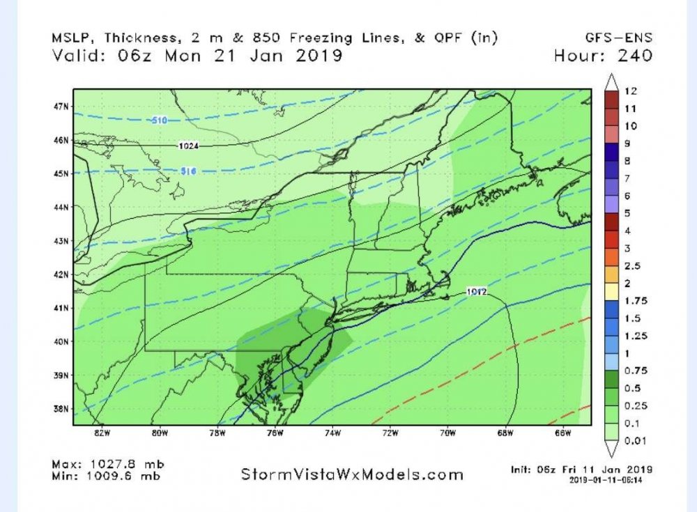
There is no moderation on the Euro at all.
-
1
-
-
4 minutes ago, Brian5671 said:
Good. Now we need a storm to attack it...(my worry is a flip to cold/dry)
Good patterns at 500 don`t have to produce snow.
Always a risk.El Nino - so we should get some S stream action tho.
-
1
-
-
It`s not so much the " look " , it`s not everything at 18k that appears red is a warm ridge.
That`s cold HP Brian extending out of E Canada.
Look underneath you are BN at 2m

-
Just now, Brian5671 said:
torchy look
lol / horrible analysis
-
2
-
-
1 minute ago, bluewave said:
The one thing that I am glad about is that this is pretty much par for the course for many El Niño’s during the early winter.
March is the New December.
-
1
-
-
7 minutes ago, bluewave said:
You can see the warmer risks with a more amped up system like the GEM and 0z Euro. But if the Euro can hold serve till under 120, then it will be something to watch. I am just tired of these cold solutions day 6-10 that get pushed back.
EVERY storm since mid DEC shifted N , so I feel your pain. The only thing I kept alluding too away was that being in p5 the ridging should have been expected.
Now I think the error is east once past the 12th or so . We will see I think the risk here is east not west this time in the L/R.
I agree let`s circle back in 5 days.
-
1
-
-
1 minute ago, bluewave said:
The control looks just like the GEM.
Plenty of time to sort it.
-
1
-
-
1 minute ago, bluewave said:
Look how the Euro is struggling from run to run past 120 hrs with such a fast Pacific flow.


Chris , the corrections began at 12 z yesterday post d10 , so I think you are looking at a different 500 evolving here.
I think you are going to see this continue in that direction as the MJO continues thru p8
I always like to wait until we are inside 5 days before I even look at E/C storms , but I think this is pretty good look off OBX

-
1
-
-
6 minutes ago, CIK62 said:
Are you really expecting a change of 22 degrees, from 52>30 in one run. Most likely the EPS is embarrassing itself for the fourth time recently, with these one-run blowoffs.
Is the GEFF is embarrassing itself too ?
Guys , wake up the warm up is ending.

-
2
-
-
4 minutes ago, bluewave said:
Looks like the same thing that the EPS was indicating for the middle of next week before it corrected to a warmer track. I don’t really trust these models with anything frozen near the coast past day 5 with such an unfavorable Pacific. But if it should survive to within 120 hrs...then game on. But I don’t want to buy so far out in time.


The corrections are post Jan 10.
Look at what is waiting for the system after the 10th on the EPS,

Then both the GEFS and Euro OP dive this that NEG off the WC and drive the ridge between Boise and Montana


The PAC is slower here and that SW never makes into the 4 Corners. The 9th had this in front of it

Again the 13th will have this out ahead of it.
Pre game / Night and Day
-
1
-
-
You `re in p8 so the ridging in the SE is gone as the NEG is diving off the W/C and not into the 4 corners.
-
1
-

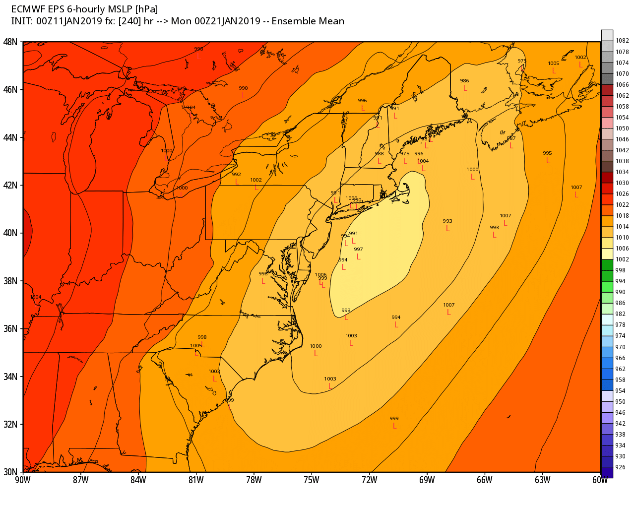


January 19-20th Winter Storm Threat
in New York City Metro
Posted
There`s a SE ridge ?
There`s a western Trough ?
huh