

PB COLTS NECK NJ
-
Posts
458 -
Joined
-
Last visited
Content Type
Profiles
Blogs
Forums
American Weather
Media Demo
Store
Gallery
Posts posted by PB COLTS NECK NJ
-
-
Just now, NEG NAO said:
so you are predicting the pattern will flip after the 5 day warm up and we will be going into a cold snowy pattern from Boston - philly along the coast ?
I never predict snow in the L/R ever.
I predict temps.
You may be cold and dry , but the MJO is going into p8 and then p1 after a brief 5 or so day warm up.
So you may have a shot to snow while you are in those favored phases , but no one can tell you for sure.
So p8 , p1 and return to colder weather after the warm up yes I am predicting that
-
 1
1
-
-
Here are your next 15 days

Here`s your break


-
8 minutes ago, NEG NAO said:
phase 8 is still a ways away the other teleconnections will have a say as to how or if this current pattern changes - no guarantees - so at this point its time to curb the enthusiasm for awhile...…...
I told you last week that we were going into p8 , you responded are you betting against the EURO ?
Now the Euro with those awful RIMM plots which failed in early Jan have failed again see p8 .
There is a 5 day break and that`s it, I think it`s time you pay attention to the guidance.
-
5 minutes ago, mikem81 said:
Which models have the best MJO verification scores so far?
The GFS is too amped ( like in early Jan ) the EURO bias is to run into the null ( but is better IMO ) .
The VP 200 anomalies off Mike Ventrice MJO site has worked the best .
It caught the MJO back in early Jan ( you will see that on the 1st 5 pages in this thread )
And it is catching it again.
-
Just now, mikem81 said:
The EURO is really the only model with a favorable MJO evlolution right now. The others have it stuck in phase 6 for a bit
Ignore the RIMM plots.
-
The Euro will correct even stronger into p8.
This is why I posted last week that the RIMM plots were wrong by killing it before 8.
In fact the MJO will go into 8 and then 1


-
1
-
-
This was always going into p8

-
1
-
-
2 minutes ago, snowman19 said:
Yep, sure. You condescendingly degraded posters as usual for suggesting this breakdown was even coming at all, arrogantly, as you always do, as if you control the weather and tell it what to do. Then when the news is bad you disappear, then reappear to lecture people. And the cold is lasting less than 5 days. It’s going bye bye come Saturday. MJO phase 8, how long have we heard that battle cry now? 3 weeks. It’s coming, it’s coming. So is met winter in 4 weeks from now
There`s zero bad news for me , my call was that we turn colder from Jan 10 onward , we did.
The next 5 days are BN with L snow , then we warm for 5 days before the MJO goes back into 8.
There`s no bad news.. It hasn`t snowed - I trade energy I don`t care about your backyard , I think I posted to Brian 2 weeks ago , you may be cold and dry
Calling Brian ,,, could you enlighten the young lad pls
-
1
-
-
3 minutes ago, Brian5671 said:
10-15 days away as usual. Maybe it comes this time, maybe it doesn't, but it's getting late early. The warmup in the mid term was only seen by modeling 2-3 days ago, so anything beyond that is anyone's guess at this juncture... No guarantee the erratic MJO doesn't pop over to 4-5 again...and without blocking any arctic shots are in and out like the one this week...need something to lock it in....too much going wrong this year IMO.
The next 5 are cold , small snow shots , then we def warm for 5 days and then we prob reset.
The MJO could always wheel back into a crud p , but before it does I think it gets to 8
-
10 minutes ago, SnoSki14 said:
This assumes it gets to phase 8, many MJO forecasts have it meandering in phase 6/7.
And this year anything outside 5 days has been impossible to forecast including the MJO.
Use these , you are going back into a low amplitude p8
-
4 hours ago, snowman19 said:
Oooops. I told you the pattern was breaking right down but as always you condescendingly “opined” and degraded people. Karma
Dude , the next 5 days are well BN with 2 shots of light snow , Your " breakdown " is a 5 to 7 day period of AN , then it`s back ( in the 10 -15 ) as we head towards p8.
You guys think it`s over ? Good luck bud.


-
3
-
-
3 minutes ago, EastonSN+ said:
Hi.
Where can I harvest the GEFS and EPS Tels?
I can only find the below.


-
 1
1
-
-
1 minute ago, Brian5671 said:
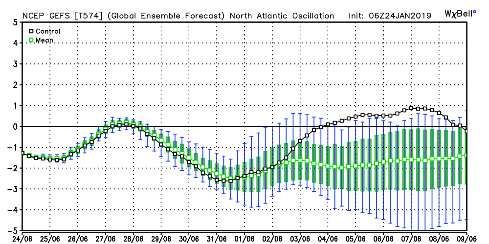
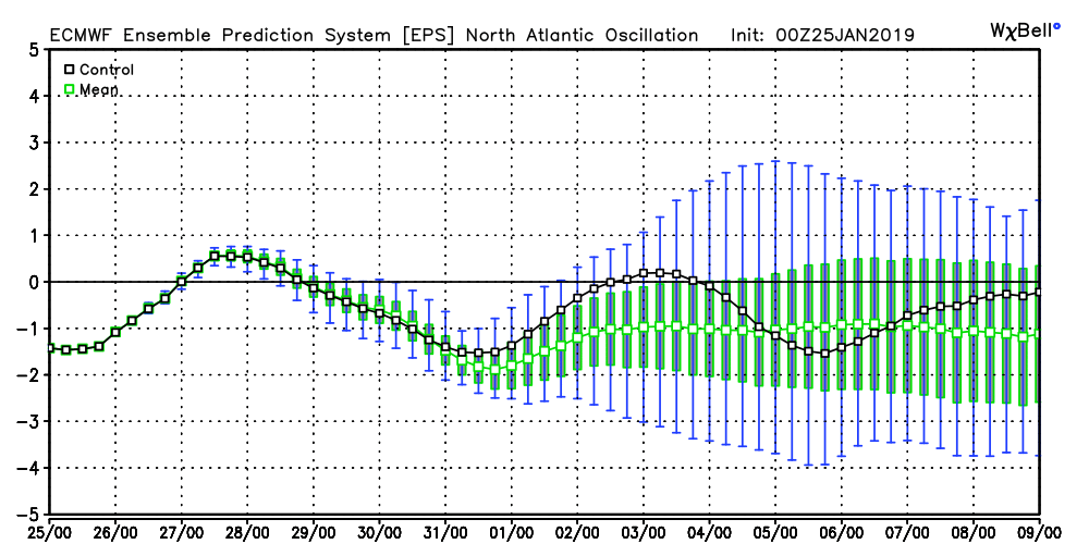
I'm a bit skeptical of the AO tanking-forecast going back a month showed a negative position, yet the reality is neutral/slightly negative....
The EPS / GEFS are - 3 to- 4 SD
-
The 6z GEFS and 0z EPS take the NAO negative after the 30th , not sure what Anthony is looking at.
-
1
-
-

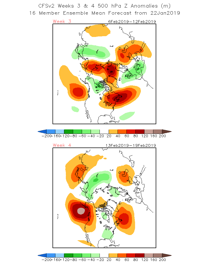
The warming is spreading from 60 E towards 80 E , and correlated to Jan 5- 11 RIMM plots in p8.
So I expect that we get to p8 in early FEB.
-
1
-
-
Just now, NEG NAO said:
8 ball or ouiji board ? And I will use whatever I want and other METS are using what I am.
They aren`t - I am just trying to help you, most Mets are not using the RIMM plots , they opt for the VP200 anomalies , it filters better.
Just helping you out buddy
-
Just now, NEG NAO said:
and the MJO stays out of the game for a while in the COD
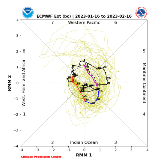
Don`t use the RIMM plots , we are going to into P7 - P8

-
15 hours ago, bluewave said:
Caribou, Maine is the big 2010’s extreme snowfall winter for January.
https://weather.com/storms/winter/news/2019-01-24-caribou-maine-all-time-snowiest-month-january-2019
Through Thursday, 50.1 inches of snow had piled up in the northeastern Maine city since Jan. 1, more than 30 inches of snow above average by this point in the month, and over 5 inches greater than its previous snowiest January – 44.5 inches in 1994 –
Another strat-warm year that produced near record in Chicago in Jan.
Let`s hope Feb 94 shows up here.
-
1
-
-
3 hours ago, Brian5671 said:
Doesn’t seem to want to get to phase 8 this year
What was Jan 5 - 11 ?
-
1
-
-
1 minute ago, Snow88 said:
Orh from sne also disagreed with him
I love to see guidance that maybe I missed , I was hoping he could show me. Another BOZO in here from Red Bank posed in here a week ago that the upcoming period would have the trough in the west.
He`s going to test zero during that period.
-
NYC will test 0 next week with or without snow on the ground.
Jan 30 /31 - Feb 4 will be the coldest 5 day period KNYC will see this winter.
-
1
-
-
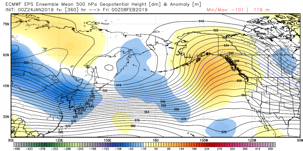
1 hour ago, snowman19 said:
There’s pretty good guidance suggesting that we go positive EPO and back to zonal come the 2nd week of February. If you look at the 200mb, the Pacific jet is gaining quite a bit a strength now over the far western Pacific again and it would appear another jet extension period is building up
Where you seeing that ?
-
3
-
-
14 minutes ago, MANDA said:
Think the main thing to take away from EPS this afternoon is that there is the threat of storm along the east coast in about a week.
Even stronger signal for another bitter cold arctic outbreak by Sunday into last week of January and perhaps into first week February.
Much higher confidence in that than any storm details at this point...overall pattern on latest eps can deliver the goods as far as extreme
cold in concerned.
Good Post.
-
12 minutes ago, romba said:
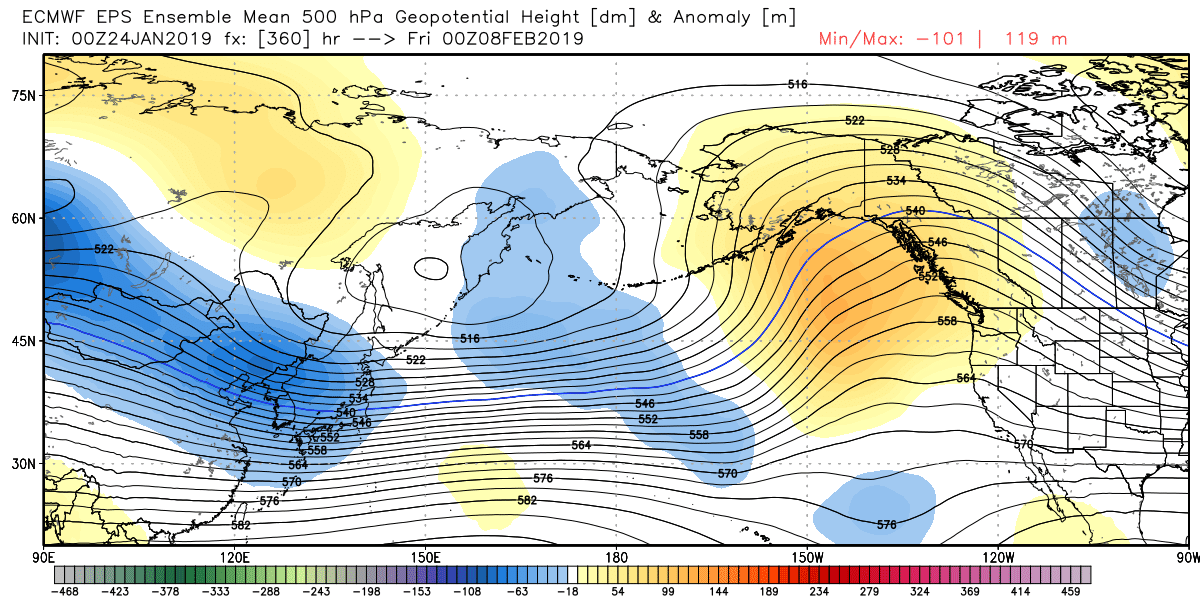
Can you, or someone else who is more knowledgeable than I answer where the cold comes from on the EPS members? The OP euro didn’t seem to have much cold available if I’m looking at it properly, thanks.
The EPS is very cold once the front clears on Friday.
-
1
-


January 2019 General Discussion & Observations
in New York City Metro
Posted
Great question man , if we get hung up in p8 and p1 then it`s prolonged , but we need to see where the sinking / convection goes after week 2.
Jan 10 - Feb 20 was my BN period , I think that will work in the end / BUT I realize if it doesn`t snow you guys don`t GAF.
And I get it.