

lilj4425
-
Posts
3,185 -
Joined
-
Last visited
Content Type
Profiles
Blogs
Forums
American Weather
Media Demo
Store
Gallery
Posts posted by lilj4425
-
-
At this rate it’s gonna be 70 and sunny this weekend. Might mow the grass or have a bbq.
-
 2
2
-
-
Just now, NorthHillsWx said:
Burrel literally pumped it into reality
I think he should start the next thread.
-
 2
2
-
-
It’s all my fault.
 I brought the mojo.
-
1
-
-
I think it’s beautiful.

-
WSW for Myrtle Beach, Florence and Wilmington:
URGENT - WINTER WEATHER MESSAGE National Weather Service Wilmington NC 332 AM EST Wed Jan 19 2022 NCZ087-096-099-105>110-SCZ017-023-024-032-033-039-054>056-058-059- 192100- /O.NEW.KILM.WS.A.0002.220121T0500Z-220122T1700Z/ Robeson-Bladen-Columbus-Inland Pender-Coastal Pender- Inland New Hanover-Coastal New Hanover-Inland Brunswick- Coastal Brunswick-Marlboro-Darlington-Dillon-Florence-Marion- Williamsburg-Coastal Horry-Inland Georgetown-Coastal Georgetown- Central Horry-Northern Horry- Including the cities of Lumberton, Elizabethtown, Bladenboro, Whiteville, Tabor City, Chadbourn, Lake Waccamaw, Burgaw, Surf City, Wilmington, Masonboro, Myrtle Grove, Ogden, Carolina Beach, Seagate, Boiling Spring Lakes, Leland, Shallotte, Oak Island, Long Beach, Southport, Sunset Beach, Bennettsville, McColl, Hartsville, Darlington, North Hartsville, Dillon, Florence, Marion, Mullins, Kingstree, Myrtle Beach, Socastee, North Myrtle Beach, Garden City, Little River, Andrews, Georgetown, Murrells Inlet, Conway, Longs, Bucksport, Loris, Green Sea, and Aynor 332 AM EST Wed Jan 19 2022 ...WINTER STORM WATCH IN EFFECT FROM LATE THURSDAY NIGHT THROUGH SATURDAY MORNING... * WHAT...Freezing rain will be the primary wintry precipitation occurring throughout the watch period. Widespread significant ice accumulations are possible with early estimates at 0.20 to 0.40 inches, except around one tenth of an inch along the immediate coast. * WHERE...Portions of Northeast South Carolina and Southeast North Carolina. * WHEN...From Midnight Friday through Noon Saturday. * IMPACTS...The forecasted ice accumulations will make traveling extremely hazardous if not impossible. Power outages and tree damage will likely occur with these potential ice amounts. PRECAUTIONARY/PREPAREDNESS ACTIONS... Monitor the latest forecasts for updates on this evolving and potentially extremely hazardous winter storm. && $$ dch
-
1
-
-
GSP:
.SHORT TERM /THURSDAY THROUGH FRIDAY NIGHT/... As of 305 AM EST Wednesday: Precipitation now appears to evenly transition from primarily isentropically-lifted air over a developing in-situ CAD wedge in the near-term, to synoptically- driven by late Thursday. A sharpening, positively-tilted 500mb trough will cross the Ohio Valley on Friday, generating a slew of forcing, basically from the start of the forecast period, along the remnant frontal boundary east of the forecast area and strengthening a surface cold layer via evaporative cooling. As noted by the previous forecaster, none of the deterministic models depict the development of a cutoff low any longer, in favor of simply deepening the trough as it enters the forecast area Friday evening. A 250mb jet will simultaneously develop over Tennessee, which should serve to enhance coastal cyclogenesis should it align well with midlevel features. The GFS and CMC, for example, have consistently toned down the strength of the surface lows they develop as the best upper forcing sets up south and east of the midlevel baroclinic zone; the latest ECMWF, by contrast, aligns 250mb divergence, 500mb DPVA, and the location of the developing surface low quite well, such that the cyclone becomes much deeper than the other models depict. At the very least, models have improved in their timing of events - with the latest runs of all three global models indicating that activity will peak from 00Z to 06Z Saturday. Which of these solutions plays out will be crucial in determining what sensible weather is produced for the western Carolinas. A stronger low translates to better moisture flux as the low travels up the coast, and also more pronounced 850mb WAA. Consequently, the GFS and CMC both depict comparatively small QPF totals vs. the ECMWF; but because the ECMWF depicts the strongest low-level WAA Friday night, it also brings a warm nose farther inland and depicts a greater likelihood of frozen p-types compared to the basically rain-snow solutions of the GFS and CMC. All things considered, however, uncertainty still looms large in this forecast. Even a cursory look at ensemble guidance indicates considerable question over the ultimate location of the developing surface low, and the timing of dry air arriving in the Carolinas on the tail end of the system, which would impact the duration of any precipitation.
-
How does the NAM look? Guess I’m the only one who is awake right now.
 Third shift life.
-
1
-
-
29 minutes ago, wxdawg10 said:
paste job triangle SW and NE on EURO. feels like models are all in agreement. Hopefully everyone gets at least a little snow at some point.
Models are nowhere near in agreement. NAM gives me almost a foot while Euro is bone dry.
-
1
-
-
15 minutes ago, chris624wx said:
0Z Euro looking mighty fine for SE VA! Loving the model consensus for the area today. Fingers crossed!
I guess it looked bad for everybody else. Lol.
-
1
-
2
-
-
7 minutes ago, BornAgain13 said:
The 0z NAM, RGEM and GFS kuchera maps all look almost identical
Almost. Lol. NAM dumps almost nine inches here while the GFS is still zero. RGEM threads the middle of the two. However, the GFS was an improvement compared to earlier runs.
-
The NAM just caused me to open a beer.
-
Just now, burrel2 said:
Euro is literally bone dry for the upstate and the NAM is dropping 10 inches of low ratio snow. you tell me?
I wonder if GSP is ripping their hair out yet. Lol.
-
1
-
3
-
-
8 minutes ago, Snow dog said:
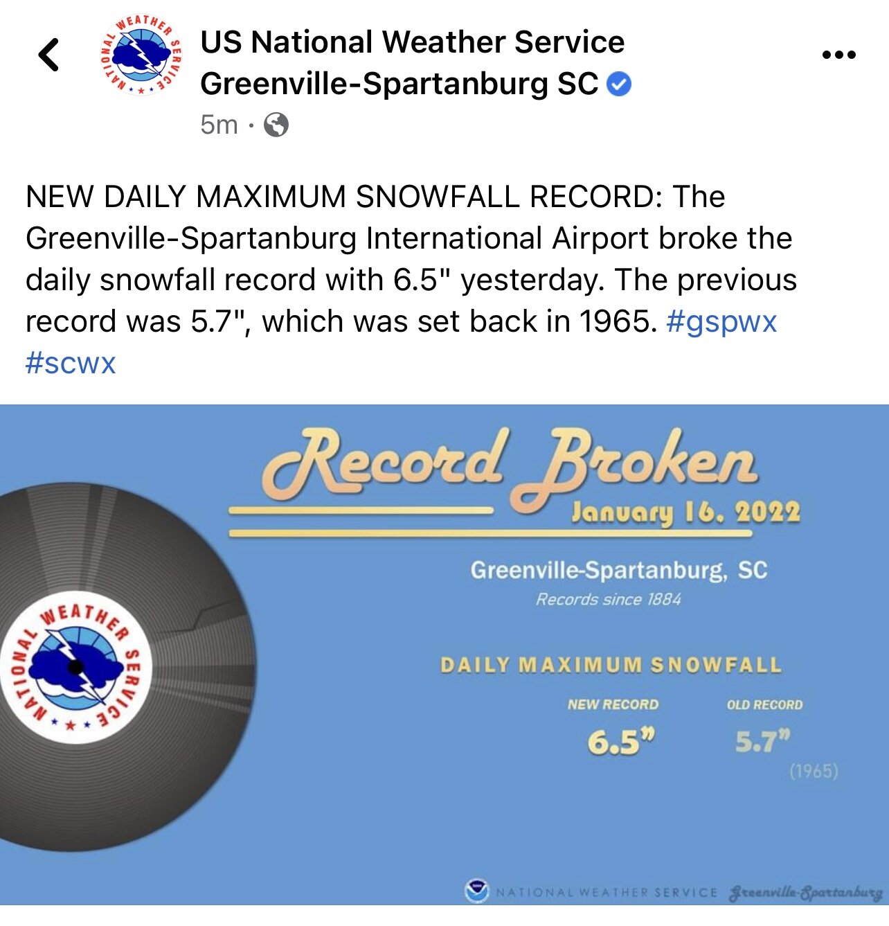
Cant believe Justus would post that graphic (possible 8" in upstate). It's what got him in trouble in his earlier years, and really hurt his reputation..
It wasn’t Chris who posted it. One of the other mets at WYFF did. Maybe he had to approve it though first due to being chief met. Not sure.
-
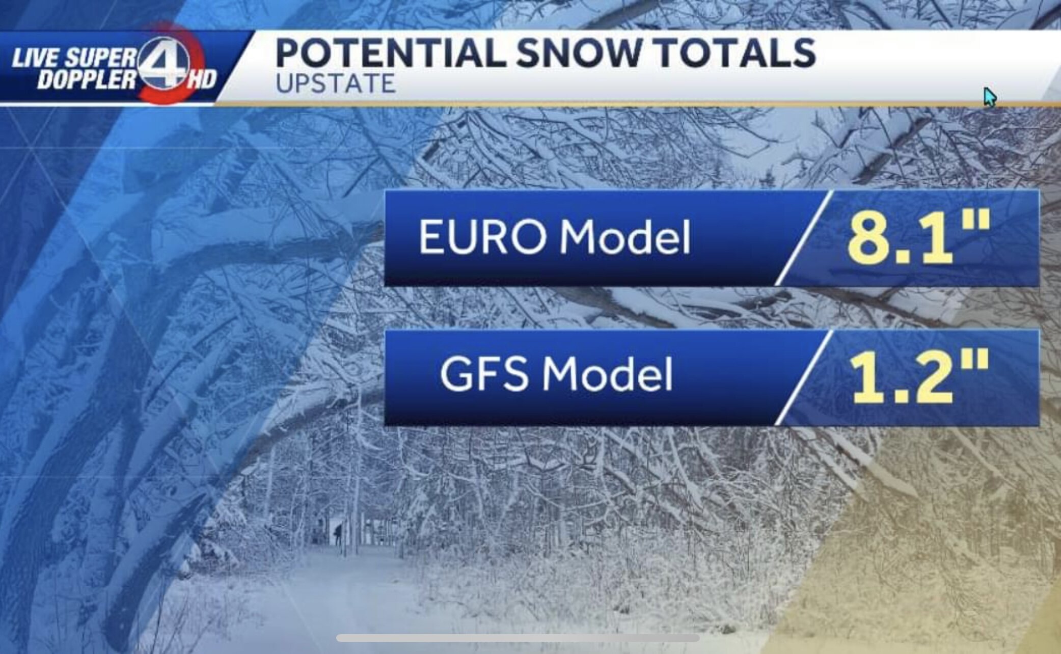
Just a “slight” difference between the Euro and GFS:

-
6
-
-
I have no idea what’s happening anymore with this weekend’s threat.
 The posts on that thread are all over the place.
  Send hel…beer.
-
I wouldn’t be surprised and fully expect the Euro to come in line with the Ukie on its next model run. They usually follow in tandem with each other.
-
2
-
 1
1
-
-
7 minutes ago, Tony Sisk said:
Where is burrell2? I don’t believe I’ve seen his name in this thread. He was fantastic with the last storm!
He’s viewing this thread right now.
-
1
-
-
-
The sun is coming out. WTF?


-
3
-
-
Everybody just stay calm and relax. I will bring you the mojo. Weather models love Bloo Q Kazoo.
-
3
-
 2
2
-
1
-
-
And like a light switch, back to all snow.
-
5
-
-
6 minutes ago, burrel2 said:
i'm getting obliterated by this last little band that's pivoting right over the western upstate. Think i'm gonna wind up with at least an inch from this.
The deform band appears to be weakening.

-
4 minutes ago, gman said:
We got about 6 inches of snow before the sleet mixed in. It's now 26 degrees with all sleet and howling winds. This storm has gone from fun and games to downright scary. Also, I was looking at future radar returns. If that moisture out in Alabama holds together, look out. We are going to either get hit with another round of heavy snow or a crippling ice storm.
That qpf back out west in Alabama will be snow when it gets here thankfully. I believe it’s the deform band.
-
12 minutes ago, olafminesaw said:
I appreciate your insight. Definitely just kidding around here. Hard to get excited about something 6 days away when it's currently snowing outside, but wow, who thought we'd get such a stellar pattern out of this winter
December flowers bring January snow showers?


-
1
-
Southern Sanitarium
in Southeastern States
Posted
I love watching my thread implode.