

lilj4425
-
Posts
3,185 -
Joined
-
Last visited
Content Type
Profiles
Blogs
Forums
American Weather
Media Demo
Store
Gallery
Posts posted by lilj4425
-
-
2 minutes ago, gman said:
Snow mixing in with rain at the base of Paris Mtn. in Greenville. All snow as you head up Altamont Rd.
Dang, that’s crazy how close it is.
-
 1
1
-
-
9 minutes ago, Blue_Ridge_Escarpment said:
9Z SREF just crushes WNC. Basically everyone west of 77
4.90 inches here at GSP. Lol
-
1
-
-
Still 44 degrees. Not expecting anything here with that but rain.
-
1 minute ago, JoshM said:
Thru Hour 36, GFS snow totals are up from 18z.
That right there tells me the HRRR is out to lunch. Poor thing is all by itself. It will be okay little buddy.

-
1
-
-
5 minutes ago, BornAgain13 said:
0z 3K NAM & 0z RGEM
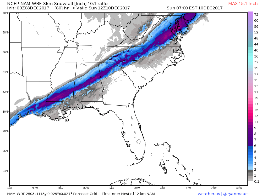
Dang...that’s similar especially in Upstate SC
-
1
-
-
Just remember who created this thread.
") It’s all the blue turd’s fault. Bloo Q Kazoo.
It’s all the blue turd’s fault. Bloo Q Kazoo.
-
2
-
-
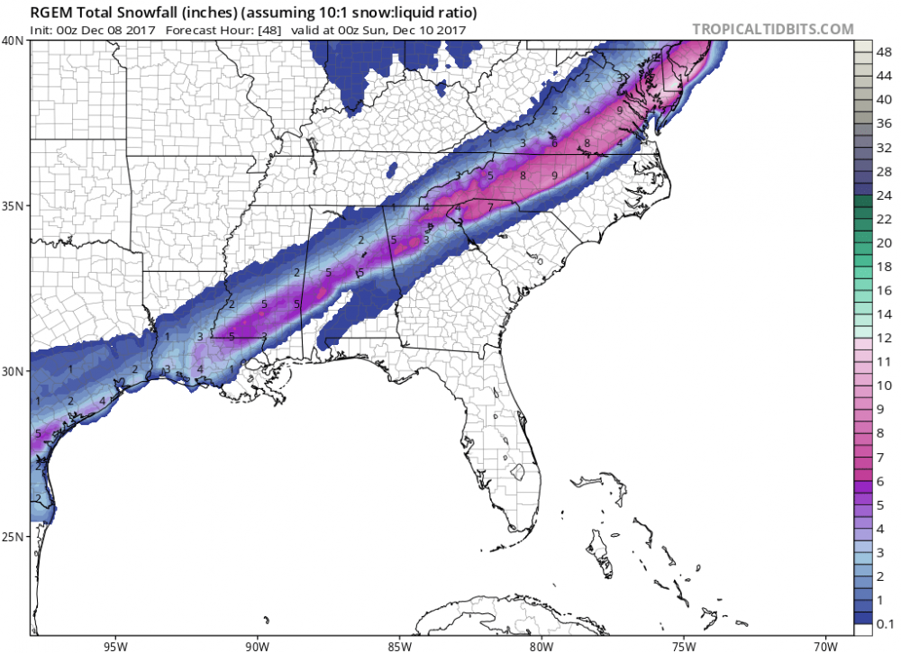
2 minutes ago, Disc said:

Looks a lot like the NAM.
-
1
-
-
Any maps or links of the RGEM?
-
5 minutes ago, packbacker said:
LOL...0z NAM. Raleigh getting NAM'd...like salt in the wounds.

These dang models won’t stop flip flopping. HRRR came in warmer but NAM and SREF came in colder. Do something isohume.
-
1
-
-
1 minute ago, CummingGaSnow said:
Could the map be posted? I'm very anxious to see what it looks like!
http://www.spc.noaa.gov/exper/sref/srefplumes/ One member has me getting 15 inches. LOL.
-
1
-
-
3 minutes ago, WarmNose said:
It will make its own cold air. Rates will overcome

Need a high pressure in the northeast. Would make me feel better.
-
1
-
-
21 minutes ago, DopplerWx said:
past 2 hrrr runs have really warmed for much of nc for tomorrow.
21z run:

23z run:

Well, if that’s not the nail in the coffin.


-
1
-
-
2 minutes ago, burrel2 said:
FYI, I've found this RGEM product's rain/snow/mix line to be deadly accurate in past events...
http://collaboration.cmc.ec.gc.ca/cmc/cmdn/pcpn_type/pcpn_type_gem_reg.html

Talk about you and me being right on the line. Lol. I-85 is the split for sure.
-
3 minutes ago, burrel2 said:
Won't be the first time they've busted badly.
Maybe isohume will bust badly on the wrong end for once. Wishful thinking but one can hope. Lol.
-
1
-
-
2 minutes ago, mackerel_sky said:
If y'all in the upstate were holding out hope for snow, the 18z GFS , will crush your hopes
Too warm?
-
1
-
-
13 minutes ago, SimeonNC said:
I doubt GSP are going to issue any advisories other than the HWO.
This system doesn’t even deserve a HWO. Maybe a SWS instead.
-
1
-
-
8 minutes ago, BretWheatley said:
Well, damn. They really didn't sugar-coat that - lol
Even the mountains look depressing. Lol.
-
3 minutes ago, WarmNose said:
We've been NAM'd again
Thank goodness. I was getting worried the models were trending back towards snow here with the latest Euro run and all. Whew.
-
3
-
-
5 minutes ago, Wow said:
NAM slower but juiced up!
Hope it loses that pesky warm nose somewhat.
-
2 minutes ago, griteater said:
My own analysis of where the Euro is supportive of snow (without regard for the snow map or precip type algorithm on the model):
1AM Fri: Snow in GA and NC Mtns, and northern NC foothills
7 AM Fri: Snow just N and NW of ATL into SE TN, GA and NC Mtns, northern NC foothills
1PM Fri: Snow NW side of ATL metro into NW and N Central GA into SE TN, GA and NC Mtns, northern NC foothills
7PM Fri: Snow NW side of ATL metro, GA and NC Mtns, northern foothills, NW Triad
1AM Sat: Snow NW side of ATL metro, GA and NC Mtns, northern foothills, Hickory to NW Triad
7AM Sat: Snow N side of CLT to Hickory to Triad
Just S and E of these areas, there could be some snow where precip bursts and cools the column...or rain/snow mix
Having said all of that, I wouldn't be surprised to see the Euro a little warmer than this on the 00z run
No Upstate SC? Bummer.

-
2
-
-
7 minutes ago, wncsnow said:
Hard not to get a little excited for areas N and W of 85 with todays trends, the EURO was especially encouraging this close to start time of the event
Unless the GFS and NAM verify. I’m North and west of I-85 and those two models have me getting zero accumulation. The Euro has me getting four inches.
-
4 minutes ago, wncsnow said:
EURO looks pretty good for Western areas.. colder and further West..
NAM and GFS vs Euro.
-
9 minutes ago, odell.moton said:
Chris has a dusting to a inch
.We will be lucky to even get that. 35 degrees and rain is what I’m expecting.
-
1
-
-
17 minutes ago, Queencitywx said:
Looking at soundings, the warm layer that is on the NAM isnt on the GFS. We're fighting the surface on the GFS.
So we get screwed either way then. Nice.


The December to Remember 7th-8th blue turd winter threat thread.
in Southeastern States
Posted
I didn’t know I was. Lol.