

lilj4425
-
Posts
3,185 -
Joined
-
Last visited
Content Type
Profiles
Blogs
Forums
American Weather
Media Demo
Store
Gallery
Posts posted by lilj4425
-
-
Just knock my power out already.
-
 1
1
-
-
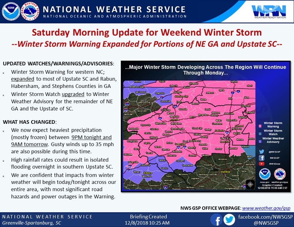
GSP just expanded the winter storm warnings.
-
 1
1
-
-
Just kill this storm system off already. I’m tired of waiting.
-
1 minute ago, kvegas-wx said:
So the heavy precip looks to be nearly finished by tomorrow night. Which feature are we looking at to extend this into Monday? Originally I thought it was just a slow system riding up the coast. But after seeing a couple models kick this quickly OTS over night, is there a second low swinging thru? I saw a mention of a double barrel low thru my weary eyes overnight.
Is that a second wave over Fort Worth, Texas? That’s what I was thinking. I might be wrong though.
-
2 minutes ago, burrel2 said:
The plot has definitely thickened. Both of the Hi-res short range models are in lock-step with each other, (hrr and rap).
Both of those models have walhalla to pickens to travelers rest with an isothermal all snow sounding starting at midnight through about 4 or 5 am before they would transition to sleet.
From clemson to easley to DT greenville... both models have us going from rain to sleet around midnight and staying sleet for the rest of the storm. These models also are only .2 ish degree's away from being isothermal from midnight to 4am... the difference between isothermal and not for those 4 hours will be the difference between 5 or 6 inches of snow or 1 inch of sleet.
.2!?!?!? Talk about a tough forecast for GSP...yeesh.
-
And burrel2 drags me back in.

-
4 minutes ago, Dunkman said:
I have a feeling everyone who isn't in the mountains or Virginia is gonna end up here before we're done. As for us in the triad, I really don't like being a few miles from disaster on both the NAM and RGEM.
Too late. Storm cancel.
-
It’s raining. What is this crap? Where is the snow?
 What a waste of qpf.
-
2 minutes ago, JoshM said:
 not this time
70 and sunny? hopefully?

-
5 minutes ago, wncsnow said:
And dsaur
He went to Pandora.
-
2 minutes ago, jburns said:
Maybe you guys but I'm more like this.


-
Just now, burrel2 said:
Going off the crude ncep maps it looks like the fv3gfs is going to come in colder and snowier for the upstate. This model is either going to go out in flames, or live in infamy after this storm.
We are going to see 33 and rain or three feet of snow. Just not sure which yet.
-
1
-
 1
1
-
-
Just now, JoshM said:
I love this... I still don't know what kind of precip I'll get. Do I need a shovel or a generator
I know I need booze
I bought Jim Beam and beer. I’m good to go for 33 and rain.
-
The difference between the NAM and GFS is crazy. Still no model consensus. What are the birds, worms, and squirrels doing?

-
I get an inch off the NAM. Woohoo. I’m saved.
-
Just now, audioguy3107 said:
Did you get scolded for not "brining anything to the table"?
Yes.
I feel like that Wilkesborodude guy now. 
-
 1
1
-
-
I was a bad boy today on the forum.
-
1
-
-
1 minute ago, QC_Halo said:
He’s venting at your useless posts...
It was posted in the wrong thread. I deleted it. My apology.
-
Just now, Wow said:
Your posts are worthless. Please stop posting.
This is the vent thread.

-
 1
1
-
-
1 minute ago, Wow said:
Yes, now please go away. You serve absolutely no purpose.
I meant to post that in the banter thread. I deleted it.
-
1
-
-
Well, the storm thread died I see.
-
1 minute ago, wncsnow said:
FV3 looks great still. Widespread 12-18 wallop from Danville SE to Winston to Hickory to AVL
It’s been consistent too. Can’t ignore that.
-
-
5 minutes ago, burrel2 said:
I'm throwing in the towel for my back yard. I'll be lucky to get a dusting of sleet and a glaze of ice Sunday morning before melting that afternoon.
I'm traveling to my in-law's house on the NC/SC border at 3000 feet in the morning though. Figure we will get smoked there!
Me too. It’s over.
December 8-10, 2018 Winter Storm
in Southeastern States
Posted
Nice to see you Phil. Really enjoy your insight as always.")