

tmagan
-
Posts
8,932 -
Joined
-
Last visited
Content Type
Profiles
Blogs
Forums
American Weather
Media Demo
Store
Gallery
Posts posted by tmagan
-
-
15 hours ago, David-LI said:
I don't remember which winter it was but we kept having shots of dry cold weather for days followed by rain, rinse repeat all winter. That is the worst.
I do, it was called the 1980's.
-
 2
2
-
 1
1
-
-
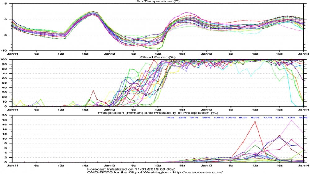
Be careful with the RGEM ensemble mean tonight because judging by the 00Z meteogram, a few outliers are driving the mean up.
00Z RGEM ensemble meteogram for Washington D.C.
-
Here is the last NHC advisory on Andrew just before landfall.
ZCZC MIATCPAT4
TTAA00 KNHC 240249
BULLETIN
HURRICANE ANDREW ADVISORY NUMBER 31
NATIONAL WEATHER SERVICE MIAMI FL
11 PM EDT SUN AUG 23 1992...EXTREMELY DANGEROUS HURRICANE ANDREW BEARING DOWN ON SOUTHEAST
FLORIDA...
HURRICANE WARNINGS REMAIN IN EFFECT FOR THE CENTRAL AND NORTHWEST
BAHAMAS...THE FLORIDA EAST COAST FROM VERO BEACH SOUTHWARD THROUGH
THE FLORIDA KEYS TO THE DRY TORTUGAS INCLUDING FLORIDA BAY...THE
FLORIDA WEST COAST SOUTH OF VENICE...AND FOR LAKE OKEECHOBEE. A
HURRICANE WATCH AND A TROPICAL STORM WARNING ARE IN EFFECT FOR THE
FLORIDA EAST COAST FROM VERO BEACH NORTHWARD TO TITUSVILLE...AND ON
THE FLORIDA WEST COAST NORTH OF VENICE TO BAYPORT.
AT 11 PM EDT...0300Z...THE CENTER OF ANDREW WAS LOCATED NEAR
LATITUDE 25.4 NORTH...LONGITUDE 78.1 WEST OR ABOUT 135 MILES
...220 KM...EAST OF MIAMI.
ANDREW IS MOVING TOWARD THE WEST NEAR 16 MPH...26 KM/HR... AND THIS
MOTION IS EXPECTED TO CONTINUE THROUGH MONDAY. ON THIS PATH THE
CENTER OF ANDREW WILL CROSS THE COAST NEAR MIAMI FLORIDA AROUND
DAYBREAK MONDAY MORNING.ALL PRECAUTIONS TO PROTECT LIFE AND PROPERTY SHOULD NOW BE
COMPLETED. TROPICAL STORM FORCE WINDS ARE EXPECTED TO SPREAD ACROSS
PORTIONS OF THE SOUTHEAST FLORIDA COAST DURING THE NEXT FEW HOURS.
MAXIMUM SUSTAINED WINDS ARE NEAR 140 MPH...225 KM/HR...AND
SOME FLUCTUATIONS IN STRENGTH ARE LIKELY PRIOR TO LANDFALL.
NASSAU...BAHAMAS...REPORTED SUSTAINED WINDS OF 85 MPH...WITH GUSTS
TO 105 MPH NEAR 830 PM EDT...0030Z.HURRICANE FORCE WINDS EXTEND OUTWARD UP TO 30 MILES... 45 KM...
FROM THE CENTER...AND TROPICAL STORM FORCE WINDS EXTEND OUTWARD UP
TO 105 MILES...165 KM.
ESTIMATED MINIMUM CENTRAL PRESSURE IS 937 MB...27.67 INCHES.
STORM SURGE FLOODING OF 10 TO 14 FEET ABOVE NORMAL TIDES ARE
POSSIBLE FOR SOME LOCATIONS ON THE NORTHWEST BAHAMAS...WITH UP TO 18
FEET POSSIBLE FOR THE NORTHWEST SIDE OF ELEUTHERA ISLAND. STORM
SURGES OF 7 TO 10 FEET ABOVE NORMAL TIDES ARE POSSIBLE FOR THE
FLORIDA EAST COAST AND KEYS NEAR TO WHERE THE CENTER MAKES LANDFALL
IN SOUTHEAST FLORIDA...WITH POSSIBLE HEIGHTS OF 9 TO 13 FEET IN
BISCAYNE BAY. STORM SURGES OF 7 TO 11 FEET ARE POSSIBLE ON THE
FLORIDA WEST COAST NEAR AND TO THE SOUTH OF THE CENTER AFTER THE
PASSAGE OF THE HURRICANE.
RAINFALL AMOUNTS OF 5 TO 8 INCHES ARE EXPECTED ALONG THE PATH OF THE
HURRICANE.
A FEW ISOLATED TORNADOES ARE POSSIBLE IN SOUTH AND CENTRAL FLORIDA
TONIGHT AND TOMORROW.
REPEATING THE 11 PM EDT POSITION...25.4 N... 78.1 W. MOVEMENT TOWARD
...WEST NEAR 16 MPH. MAXIMUM SUSTAINED WINDS...140 MPH.
MINIMUM CENTRAL PRESSURE... 937 MB.
INTERMEDIATE ADVISORIES WILL BE ISSUED BY THE NATIONAL HURRICANE
CENTER AT 1 AM EDT AND 3 AM EDT FOLLOWED BY THE NEXT
COMPLETE ADVISORY ISSUANCE AT 5 AM EDT...MONDAY. -
There is a buoy in the eye that reported a wind gust of over 90 knots.
-
Soulik probably wont be at typhoon intensity when it makes landfall in Korea, but fairly remarkable that Thursday will have simultaneous possible typhoon landfalls in Japan and Korea.
-
Reading all this reminds me of a NHC Hurricane Floyd forecast discussion from 1999:
ZCZC MIATCDAT3 ALL
TTAA00 KNHC DDHHMM
HURRICANE FLOYD DISCUSSION NUMBER  24
NATIONAL WEATHER SERVICE MIAMI FL
11 AM EDT MON SEP 13 1999

THE INITIAL MOTION REMAINS 280/12.  THE MODEL GUIDANCE ALSO REMAINS
BASICALLY UNCHANGED...CALLING FOR AN EROSION OF THE RIDGE TO THE
NORTH OF FLOYD AND A GRADUAL TURN TOWARD THE NORTH.  THE OFFICIAL
TRACK FORECAST IS VERY SIMILAR TO THE PREVIOUS ADVISORY EXCEPT A
LITTLE FASTER AND NOW SHOWS THE CENTER CROSSING THE SOUTH CAROLINA
COAST AFTER 48 HOURS.

THERE ARE NO IMPORTANT CHANGES IN THE MOTION OF THE HURRICANE OR IN
THE TRACK GUIDANCE AND NONE OF THE GUIDANCE BRINGS THE HURRICANE
OVER SOUTHEAST FLORIDA.  HOWEVER SINCE FLOYD IS FORECAST TO MOVE
DANGEROUSLY CLOSE TO SOUTHEAST FLORIDA...AS PRECAUTIONARY MEASURE
...A HURRICANE WATCH IS EXTENDED SOUTHWARD TO INCLUDE DADE
COUNTY FLORIDA.  THE OFFICIAL FORECAST TRACK ALSO REQUIRES THAT THE
HURRICANE WATCH BE EXTENDED NORTHWARD TO JUST SOUTH OF BRUNSWICK
GEORGIA.

RECON FLIGHT LEVEL WINDS AND GPS DROPS IN THE EYEWALL SUPPORT 135
KNOTS SUSTAINED SURFACE WIND.  THE LATEST RECON CENTRAL SURFACE
PRESSURE IS 921 MB WHICH CORRELATES WITH 140 KNOTS...AND THE
HURRICANE COULD EVEN GET A LITTLE STRONGER IN THE NEXT COUPLE OF
DAYS.  HOWEVER 135 KNOTS SHOULD BE STRONG ENOUGH TO GET EVERYONES
ATTENTION.

LAWRENCE

FORECAST POSITIONS AND MAX WINDS

INITIAL     13/1500Z 24.1N  72.1W   135 KTS
12HR VT     14/0000Z 24.5N  74.0W   135 KTS
24HR VT     14/1200Z 25.5N  76.5W   135 KTS
36HR VT     15/0000Z 27.3N  78.8W   135 KTS
48HR VT     15/1200Z 29.6N  80.3W   135 KTS
72HR VT     16/1200Z 35.0N  80.5W    65 KTS...INLAND
-
Islip, NY has just observed nine inches of snow in two hours, something you see in the great lake effect bands.
-
1
-
-
Just now, SnowGoose69 said:
Even if it hits the US I'm not sure what sort of shape it's in at that point. It's not really taking a trajectory over a favorable area. I'm thinking a 75-90 mph cane at the worst
Remember how much Gloria weakened moving up the east coast in 1985, coincidentally around this time period? At one time east of the Bahamas, recon measured one of the lower pressures ever found in an Atlantic tropical cyclone. Of course that has been surpassed many times in the last 32 years.
-
1
-
-
Just now, NJwx85 said:
There was a tremendous burst of -70C cloud tops in the RFQ just prior to LF. Maria was likely intensifying and might have actually recovered enough to be a cat 5 at LF.
Since then the eye on IR has completely collapsed as Maria's center begins to interact with the mountains near the center of PR.
That was probably due to frictional convergence rather than intensification.
-
NHC will start issuing one hour position updates at the top of the hour.
-
When Gilbert bisected Jamaica in 1988, it was a 115 mph hurricane. By the time it reached the western tip of the island, you can tell on the satellite the eye was degrading. About two satellite frames after leaving the western tip of Jamaica, the eye wall was already restrengthening.
-
Hong Kong just had a wind gust to typhoon force.
-
Noru certainly has that 'truck tire' appearance.
-
It can be seen via Kunsan AFB radar.
-
I am seeing on discussion groups that the EMWIN Internet feed will be discontinued at the end of the year. Since some weather alert software programs use that feed, what will be around to replace it?
-
Just watching CNN international weather and saw that Montpellier, France (on the south coast) had 10.6" of rain in a four hour period on Monday.
-
When was the last time Central Park hit 90 in the month of October?
-
Islip will have enough rain today that would put them in the Top 10 of Central Park's all time wettest months.
-
Islip in six hours has seen more rain than Central Park has in any day since 1869.
-
Now Islip has 7.00" of rain in essentially a six hour period.
-
When was the last time Central Park hit 90 in October?
-
Kind of remarkable that the longest streak of 90 degree plus days at Central Park was 60 years ago.
-
Consider what has occurred in Islip, NY in the last six months:
Tornado just outside Islip in August 2012.
Hurricane Sandy (albeit not making landfall there) in October 2012.
Verifiable blizzard conditions in February 2013.
How many places can you say have had a tornado, hurricane, and a blizzard all in a six month period?
-
I've been thinking, it's pretty remarkable (and sad) how many tornado and death toll benchmarks have been set so far this year:
~ worst (# of tornadoes) outbreak in NC history, possibly of all time, but at least since 1884
~ worst tornado outbreak in AL history, definitely in terms of deaths, possibly also in terms of total tornadoes
~ possibly the most prolific tornado day in U.S. history (4/27/2011)
~ deadliest U.S. tornado outbreak since at least 1936 (if you consider the Tupelo and Gainesville tornadoes both parts of one outbreak), or possibly 1925
~ deadliest single U.S. tornado since either 1953 (if 116 death toll in Joplin holds), 1947, or 1936 (if you consider the Woodward event to have been more than a single tornado)
That's a lot to bear in just one year.
Reminds me of the website dedicated to all of the records broken during the 2005 Atlantic Hurricane season.
Meteorological Winter 2018 Banter
in New York City Metro
Posted
The winter of 1997 - 1998 had more snow in astronomical spring than astronomical winter in Central Park.