

tmagan
-
Posts
8,932 -
Joined
-
Last visited
Content Type
Profiles
Blogs
Forums
American Weather
Media Demo
Store
Gallery
Posts posted by tmagan
-
-
Number of 150+ mph hurricanes in the entire Atlantic in the decade of the 1980's: 3.
-
 1
1
-
-
1 minute ago, SRRTA22 said:
Rotations very broad , but that's heck of a supercell for 4:30 am in NYC
If you look back at the TJFK TDWR SRV, you can see the waterspout signature, but it didn't last long.
-
1
-
-
Seoul, South Korea, the DMZ and parts of North Korea may face an 'Ida' situation Monday as Hinnamnor moves to the south of the peninsula. Both the GFS and ECMWF have a foot of rain for Seoul. Keep in mind the peninsula is not flat either.
-
12Z EPS gives a 10 - 15 percentage chance of 10 or more inches of rain along the Red River the next two weeks.
-
Number of 100 degree days in August in Central Park:
1944 - 1955: 10
1956 - Present: 1
-
1
-
-
Happy ten year anniversary... of Central Park's last 100 degree day.
-
1
-
-
21 minutes ago, Chinook said:
when Reed Timmer tweets about your area.
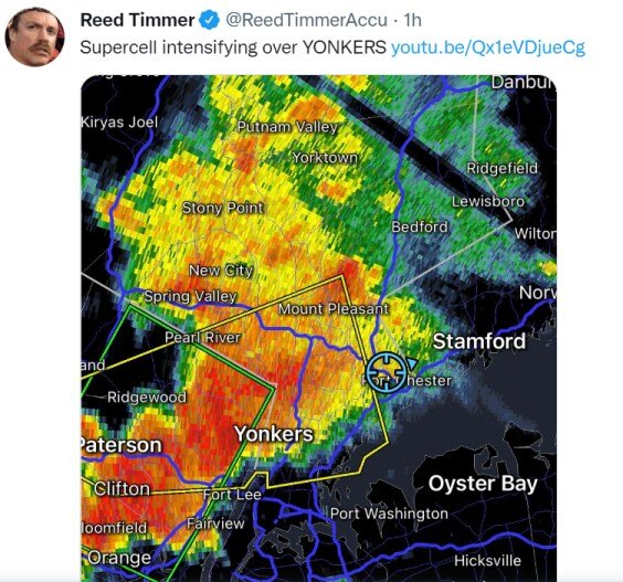
Supercell has had more of a sliding definition lately.
-
Central Park hasn't hit 80 degrees yet this year, last time the Park went that long into a calendar year without hitting 80 degrees -- 1988.
-
1
-
-
Lets take a reset:
Hurricane Warning for Henri in August, even though it didn't make landfall on Long Island, and not as a hurricane
Tornado outbreak in November
Verified blizzard conditions today
-
2
-
-
2 minutes ago, brooklynwx99 said:
I tried earlier, and it's not even really possible anymore. there's so much drifting
That is going to be a problem with measurements.
-
1
-
-
8 minutes ago, donsutherland1 said:
Arctic refers to the source region of the air mass. The Arctic has warmed quite rapidly over the past few decades, so the magnitude of cold is generally less expansive and less intense that it was then. There remain exceptions, though.
The fact that Central Park has gone nearly seven years with a winter month negative temperature departure of 4 degrees or more is a telling stat.
-
2
-
 1
1
-
-
Last winter month where Central Park averaged at least 4.0 degrees below normal: February 2015.
-
2
-
-
Last winter month where Central Park averaged at least 2.0 degrees below normal: December 2017.
-
1
-
-
3 minutes ago, donsutherland1 said:
December 2021 is finishing with a monthly mean temperature of 43.8° in New York City. That was the 3rd warmest December on record. Records go back to 1869. 5 of the 10 warmest December cases have occurred since 2000. 9 of the 10 warmest December cases have occurred since 1980.
2022 will begin with more unseasonable warmth. But a turn toward cooler weather lies ahead in the medium-range.
In the South, more near record and record heat prevailed. Preliminary records included:
Albany, GA: 87° (old record: 81°, 1951)
Baton Rouge: 84° (old record: 81°, 1974)
Charleston, SC: 78° (tied record set in 1984 and tied in 1996)
Charlotte: 73° (old record: 70°, 1996)
College Station, TX: 83° (old record: 82°, 1951)
Corpus Christi: 84° (tied record set in 2011)
Galveston: 80° (old record: 74°, 1921)
Houston: 84° (old record: 82°, 1974)
Lake Charles, LA: 80° (old record: 78°, 1933, 1934, 1964)
Meridian, MS: 84° (old record: 79°, 1951)
Mobile: 81° (old record: 78°, 1988)
Montgomery, AL: 83° (old record: 81°, 1951)
New Orleans: 83° (old record: 81°, 1971)
Pensacola: 79° (old record: 77°, 1971 and 1996)
Raleigh: 74° (old record:P 72°, 1929)
Savanah: 81° (old record: 80°, 1973 and 2015)
Shreveport: 81° (tied record set in 1951 and tied in 1964)
Tampa: 83° (tied record set in 2006 and tied in 2015 and 2018)In addition, Houston recorded its 18th 80° day of this month. The old December record was 10 days, which was set in 2012. The 18 days also matches the November record that was set in 1927. Houston also recorded its December record 8th consecutive 80° day. The old record of 5 consecutive days was set during December 3-7, 1998 and tied during December 24-28, 2016. Houston concluded December with a monthly mean temperature of 67.8°. That demolished the longstanding December mark of 64.4° from 1933. It was also high enough to tie 1909's November average, which was the 3rd warmest November on record.
January will very likely commence with an AO-/PNA- pattern. That typically favors somewhat cooler than normal readings in the East. For NYC, the January 1-10, 1991-2020 mean temperature for such cases was 33.5° (normal: 34.8°).
Late in the first week of January, the PNA could go positive. As that happens, the prospects for measurable snowfall could increase. Since 1990, 66% of days with 1" or more snow in New York City occurred when the PNA was positive. In addition, 81% of days with 4" or more snow occurred when the PNA was positive.
The latest guidance suggests that temperatures could head toward seasonal levels and then below seasonal levels as the first week of January progresses. The coldest air will likely remain confined to the Pacific Northwest, Northern Plains, and western and central Canada during that time. Afterward, the cold could press farther south into at least the northern Middle Atlantic and Ohio Valley regions. The colder pattern could last for two or perhaps three weeks before it breaks down. Thus, it could begin to break down sometime in the January 15-20 timeframe.
The ENSO Region 1+2 anomaly was -1.3°C and the Region 3.4 anomaly was -1.1°C for the week centered around December 22. For the past six weeks, the ENSO Region 1+2 anomaly has averaged -1.25°C and the ENSO Region 3.4 anomaly has averaged -0.98°C. La Niña conditions will likely persist through meteorological winter.
The SOI was +16.19 today.
The preliminary Arctic Oscillation (AO) figure was -1.516 today.
On December 29 the MJO was in Phase 7 at an amplitude of 2.052 (RMM). The December 28-adjusted amplitude was 2.308 (RMM).
In addition San Juan, PR will have a top ten warmest December with nine of the ten warmest Decembers from 1995 onward. Records began in 1956.
-
2
-
-
Central Park will have a top ten warmest OND on record.
-
There is a chance the minimum temperature on New Year's Day will be higher than the minimum temperature we had the past Memorial Day for the Park.
-
2
-
-
Here is something to look forward to in the New Year: Central Park did not record a single digit low in 2020, it certainly will not in 2021, if it doesn't happen in 2022, it will be the first time Central Park has done that in three consecutive years.
-
1
-
-
Last December with widespread negative seven degree monthly anomalies in the Northeast: 2000.
-
1
-
-
6 minutes ago, LibertyBell said:
wtf is it raining so hard in the middle of the night?
Look at the VAD wind profiles from the OKX radar, that will tell the story.
-
1
-
-
2 minutes ago, Intensewind002 said:
I believe similar happened with Hurricane Camille. That storm is probably a good analog for Ida
Fair statement
-
2 minutes ago, David-LI said:
I wonder if schools are open in Long Island due to state of emergency?
how are things in Long Island? I haven’t been outside actually working indoors
Most Long Island schools open after Labor Day.
-
4 minutes ago, guinness77 said:
I can’t believe I’m typing this but this may be the worst Metro event since Sandy. I’m keeping my fingers crossed that my area continues to dodge a bullet. I don’t think the true scope of what’s happened tonight will come to light until tomorrow and the following days either.
Long Island will be relatively unscathed compared to the City on west.
-
1 minute ago, Rjay said:
ISP doesn't have an inch yet lol
Remember, seven years ago, Islip had 11" of rain in a few hours.
-
1
-
-
Number of landfalling 150 mph hurricanes in Louisiana last two years = Two
Number of 150+ mph hurricanes in the entire Atlantic ocean during the 1980's = Three
November 2022
in New York City Metro
Posted
I'll do you one better, they just tied their record high (at three in the morning)!