

RockabilyJunior
-
Posts
55 -
Joined
-
Last visited
Content Type
Profiles
Blogs
Forums
American Weather
Media Demo
Store
Gallery
Everything posted by RockabilyJunior
-
January 12-13th Cold Smoke Obs and Nowcast
RockabilyJunior replied to Bob Chill's topic in Mid Atlantic
I measured 4 inches this morning towards the end of the last real burst of snow. Other than a light on and off dusting I haven't had anything since about 10 or 11am. I'm right next to 83 less than a mile south of the train station. -
January 12-13th Cold Smoke Obs and Nowcast
RockabilyJunior replied to Bob Chill's topic in Mid Atlantic
Don't worry. I'm under the dark blue on the bottom side of the Baltimore dot and what's fallen has only been enough to give a light dusting. -
January 12-13th Cold Smoke Obs and Nowcast
RockabilyJunior replied to Bob Chill's topic in Mid Atlantic
Any chance this moistens up and we get another inch or so out of this? -
January 12-13th Cold Smoke Obs and Nowcast
RockabilyJunior replied to Bob Chill's topic in Mid Atlantic
I'm in Baltimore. The radar over me finally looks good. I look outside. It's snowing, but not nearly as much as some light green returns from last night. What is going on? -
January 12-13th Cold Smoke Obs and Nowcast
RockabilyJunior replied to Bob Chill's topic in Mid Atlantic
It's just shifted north. It's now inner harbor / BWI snowhole.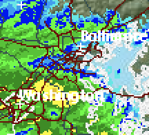
-
January 12-13th Cold Smoke Obs and Nowcast
RockabilyJunior replied to Bob Chill's topic in Mid Atlantic
Inner harbor no longer visible. Baltimore City band is extending a little south it would seem. snow_video_2019_01_13_15h_22m_52s.mov -
January 12-13th Cold Smoke Obs and Nowcast
RockabilyJunior replied to Bob Chill's topic in Mid Atlantic
I think you guys will be fine somehow. I was on the northern edge of that snow hole for a little and it's just started snowing nicely here. I'll post a video in a second. I was waiting a good hour for that Ellicot city band to make it here though. It's coming and it'll be good. -
January 12-13th Cold Smoke Obs and Nowcast
RockabilyJunior replied to Bob Chill's topic in Mid Atlantic
Finally rates are heavy enough that the snow has started to accumulate again on the southern edge of the Baltimore city snow band. -
January 12-13th Cold Smoke Obs and Nowcast
RockabilyJunior replied to Bob Chill's topic in Mid Atlantic
NWS just bumped the forecast snow for the day from 1-3 to 2-4. I wonder if that is just to account for what already fell this morning between 8-9 am or what is yet to come. -
January 12-13th Cold Smoke Obs and Nowcast
RockabilyJunior replied to Bob Chill's topic in Mid Atlantic
After I last posted at 7am that things look quiet around Baltimore City with 2-3 on the ground, things really picked up, with some moderate rates and larger flakes. I just measure 4 inches. That's what I had initially hoped for early in the week, but after yesterday's runs I was starting to expect 5 or 6, so I hope we can get another 1-2 inches before it ends. -
January 12-13th Cold Smoke Obs and Nowcast
RockabilyJunior replied to Bob Chill's topic in Mid Atlantic
Things are really quiet in Baltimore City. It's hard to tell from inside, but it looks like 2-3 inches on the ground. I'm really hoping the back side of this storm gets going and makes it up here soon.

