

EastKnox
-
Posts
161 -
Joined
-
Last visited
Content Type
Profiles
Blogs
Forums
American Weather
Media Demo
Store
Gallery
Posts posted by EastKnox
-
-
14 hours ago, John1122 said:
There's apparently an East Tennessee winter storm Facebook page that was hyping the GFS run as if it were legitimately a threat. The shame of it is it has thousands of followers.
I've seen that page too. The page hypes about every GFS fantasy storm that pops up. Those thousands of followers swear by the page's "forecasts." I can't help myself to occasionally comment and attempt to educate a few of those thousands.
-
 1
1
-
-
5 hours ago, Holston_River_Rambler said:
I'm sure some of you have heard about the recycling center fire in Knoxville. It's about 2.5 miles from my house and was watching it on radar yesterday. As I was watching it though I noticed an outflow boundary from an old storm intersecting it and that seemed to fire up a storm. Not sure if that is exactly what happened, but thought I'd share to see what y'all think:
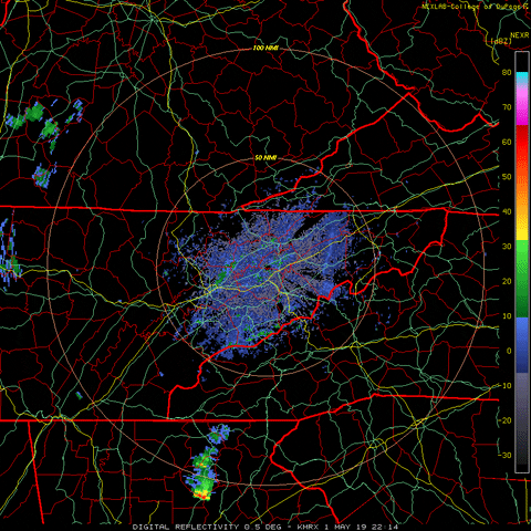
The storm I'm looking for fires over the NE sections on Knoxville, just north of downtown, at 23:20 time stamp. Just prior to that you can still see the smoke plume from the fire.
Yesterday around 5 pm, it appeared to me that a few cumulus had formed in the wake of the smoke. I wondered if the smoke/heat provided a little extra lift in that area, but thought I was nuts for thinking so. I was in the powell area around 8 pm when that second trailing storm passed south of the fire and noticed on radar (and outside observations) that the outflow boundary from the second cell pushed the smoke further north into the halls and powell area. The smell was distinct.
-
Just posting to make sure this subform is still working.

MRX WWA stands out like a sore thumb.

-
 1
1
-
-
Found this gem from WFO Louisville for all of you severe weather trackers.
-
3
-
-
1 hour ago, John1122 said:
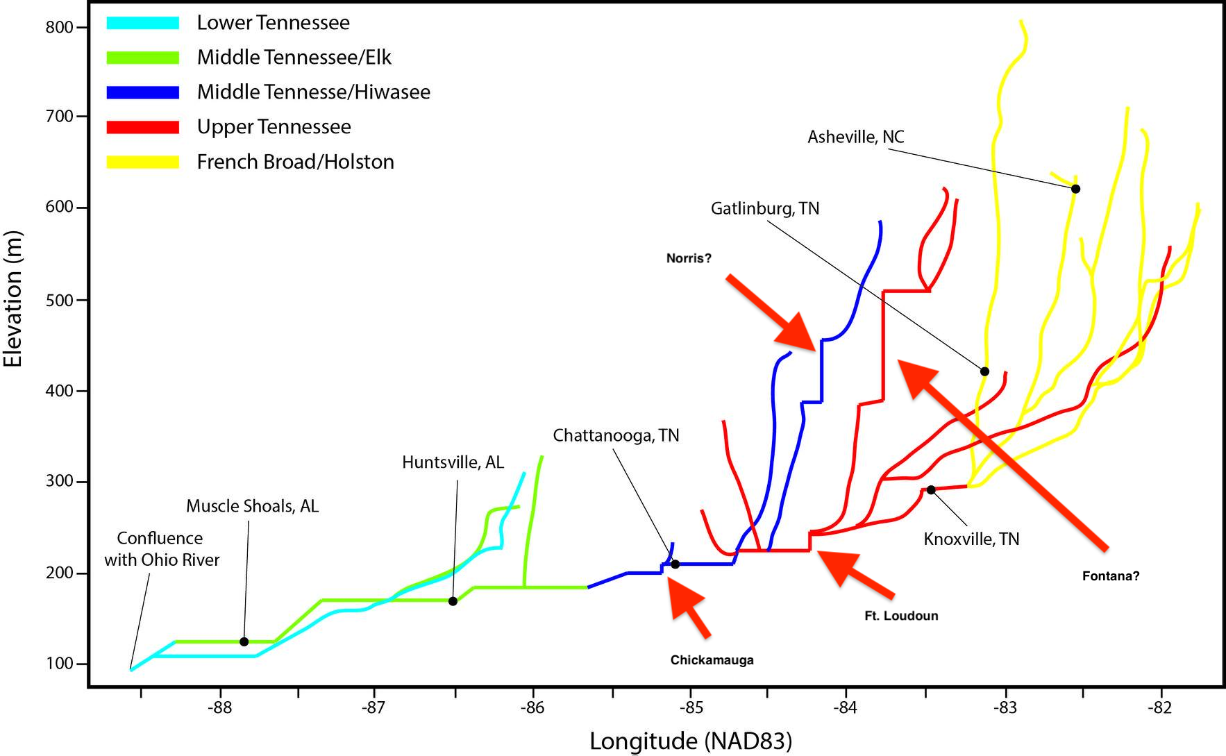
Norris is the red line with the fork just to the left of Knoxville, that's the Powell and Clinch meeting at the fork. The other red line that you are showing as Fontana is very likely the New River/Emory/Obed that originates in Western Campbell and Scott and works south through canyons on the Plateau. I think it makes Watts Bar.
That's why I put question marks because it doesn't exactly line up (obviously the map isn't designed to be to scale). The vertical drops seem to match dam heights, but the placement relative to other features doesn't seem to fit in correctly. Here are some longitude coordinates of the dams: Norris: -84.1, Fontana: -83.8, Ft. Loudoun: -84.2, Chickamauga: -85.2, Watts Bar: -84.8. Also interesting in this graphic, Knoxville is set too far east. On the map it is -83.4ish, in reality it is -83.8 (confluence of Holston and French Broad Rivers). Weather must be slow when we are dissecting a river watershed graphic.
-
1
-
-
I tried to identify some dams from this map.

-
1
-
3
-
-
Ok, ok...one more and I won't beat the dead horse any longer.
Excerpts from this article on cnn.com : https://www.cnn.com/2019/03/05/us/alabama-tornado-survivor/index.html
-----------------------
"He's pretty banged up .Really sore. He said that he heard some loud noises. He didn't even know that there was bad weather in the area. I didn't know either," she said.
"My mom told me there was supposed to be bad thunderstorms, possible tornadoes. But I mean, we hear that quite often whenever it rains bad down here,"
------------------------
So sad that people choose not to be aware of potential bad weather. They did make a good point in the article that they mostly watch Netflix, so maybe not be exposed to local bulletins. I think social media fills that gap, however, there are too many social media weathermen posting model data to the masses and each of those posts becomes "another time when the weatherman was wrong" in their minds.
I did chuckle a bit when reading the part of the second quote above equating tornado watches with heavy rain. I often wonder how many people think that way.
-
1
-
-
First of all, thoughts and prayers for families and communities that experienced loss of life and property yesterday in Alabama.
Next, does anyone else get annoyed that the media overplays the "we only had 5 minutes warning" statements? Yes, the actual tornado warnings were issued at 1:58 p.m. local time about 7 minutes before the tornado touched down. But with SPC pinpointing that area with outlooks a few days prior, Enhanced risk the day before and Tornado Watch at 11:04 a.m. local, there was plenty of warning that this could be a possibility. I know I'm tuned into the weather because I love watching it, but I think more and more people are becoming complacent with watches and warnings and largely ignoring them. The WFO's are in a tough spot between calling too many warnings and having people become immune to them - then waiting too late to call warnings and response times are not adequate.
-
4
-
-
27 minutes ago, Greyhound said:
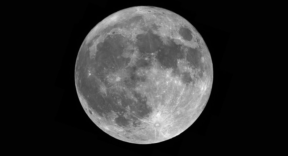
Wait.....you took 40k photos of the moon??? How long did that take??? I assume you stacked them post-processing? If you don't mind me asking....what lens did you use for that?
Yes is the short answer. The posted picture is a mosaic of 19 different photos of a more "zoomed in" view of the moon. Each one of the 19 photos was created using approx 3000 images in a row at a high frame rate...essentially a video. The stacking software identified the quality of the 3000 images and only the best 2000ish were kept to be stacked and then processed before combining into the final mosaic. I spent about an hour behind the telescope (old 8" reflector) and camera (ZWO ASI120MC-S) and then another couple of hours in various post processing software to get the final result. This was my first attempt at this kind of imaging and I aim to do another if we ever see clear skies again.
-
3
-
-
All that nice work and he forgot to rotate it....haha. I did a similar photo (composite of about 40k images) for the January 2018 supermoon.
On a side note...last day of meteorological winter. This thread will be done soon.
-
3
-
 1
1
-
-
19 hours ago, Holston_River_Rambler said:
Weathertree! Screensaver as requested:

I would cash in on this and trade it for the next 3 winters.
-
1
-
-
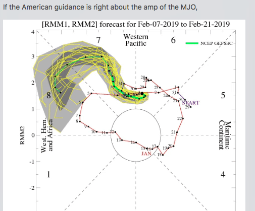
Holston - I think you are onto something in your speculation post. It appears that Maui's fish hook has appeared on the MJO.
-
1
-
1
-
-
53 minutes ago, Stovepipe said:
Almost time to get mater seeds planted in the green house! I've used florescent tubes in the past but I'm gonna try to find some cheap LED lights on Amazon this go around. Planning to go probably 2/3rds Cherokee Purples and 1/3rd Pink Brandywines. The Purples seem to be more disease resistant at my location. Last year the Brandywines got that yellow blight and never did really recover properly. I'll supplement the seedlings with some other purchased plants from Lowes but I'm aiming for 100 or more in the ground this year.

I love the Cherokee Purples. I haven't been able to put out a garden for the last 2 years but if I get a chance to grow a few tomatoes this year, Cherokee Purples it is.
-
Getting closer to the event, I particularly enjoy studying the actual and model soundings for a given location for severe wx; since tons of data is to be had in just one picture.
-
3
-
-
Thanks for putting this here, I had wondered if there was an easy way to put that part of the discussion into this thread.
-
Ended up with 1" in East Knoxville.
-
2
-
-
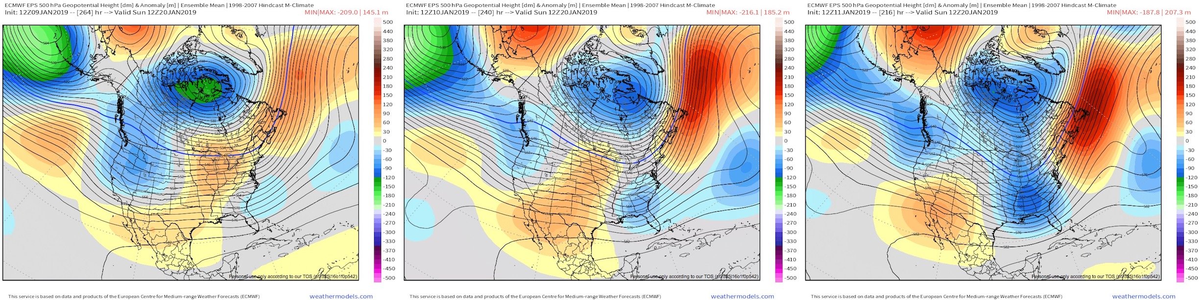
I was just studying the 12z/96h vs 18z/90h 500mb vort to look for differences that might show if the Euro us holding serve with the 12z solution. Here are the pics:Funny you should mention that.
The 18z Euro looked like it might be trying to dig a little more out west and orient the trough in such a way as to draw more moisture north, but only goes out to 90 hours, so hard to say for sure. Otherwise the energy for the midweek storm looked very similar in placement and strength to 12z.

Sent from my Moto G (5) Plus using Tapatalk
-
1
-
-
Noticed the Euro has is a little slower than the GFS. CrankyWeatherGuy mentioned the Rex block in the pacific potentially causing timing issues with models. It looks like this piece of energy rides over the top of that split. I'll be curious to see what timing adjustments might happen as this feature erodes.
-
1
-
-
Radar looking healthy in Sevier Co. right now.

Sent from my Moto G (5) Plus using Tapatalk-
1
-
-
13 minutes ago, Carvers Gap said:
The 12z EPS again moved even colder after d8. Quite a dramatic chance from d8 to d9.5.
The trend is our friend?

-
4
-
-
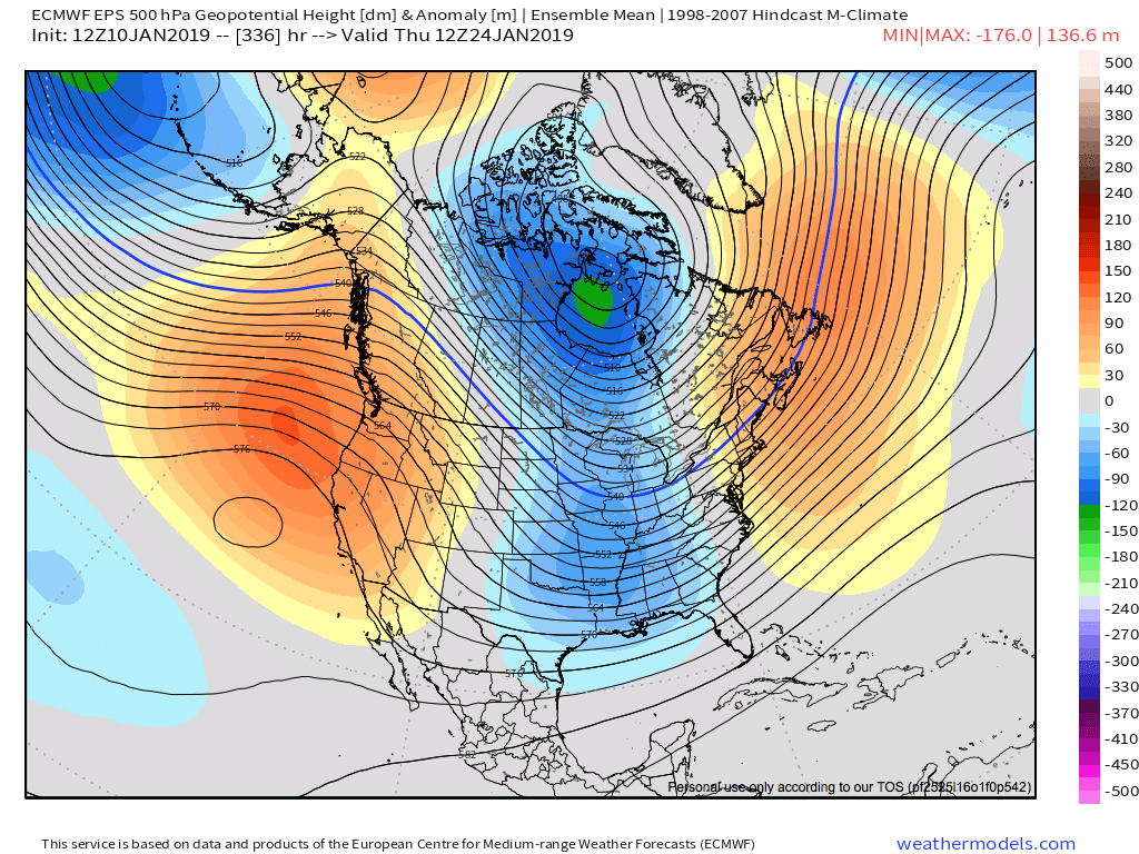
You know it's a slow day when we reminisce about past snowstorms. On a positive note, yesterday's look at 360H moved to 336H, so at least it's not getting stuck in perpetuity at day 15.

-
3
-
1
-
-
1 hour ago, Holston_River_Rambler said:
One of the prettiest fantasy runs I've seen in a while:

This would be a great birthday with for me. My birthday is Jan 25th. When I was a child, my parents asked what I wanted for my birthday and my answer was always... "a big snowstorm." We got a decent snow one time on my birthday...I had the chicken pox and wasn't allowed to go play in it.
-
1
-
1
-
-
3 minutes ago, TellicoWx said:
Ensembles lose wieght at this range, due to the general area doesn't change as much and we can look at the meso models to pinpoint more localized points within that area...members can't even figure where that area is within 48 hrs.
Are we in no mans land at the moment? The snowfall I'm looking at is happening at 48-72 hours and many agree that the mesoscale models at that range are unreliable.
-
5 minutes ago, Carvers Gap said:
The 6z GEFS mean looks about like that 6z Euro. I think at this point we can call that a trend. No sugar coating it.
Not looking good. It looks like the LP slides OTS without making much of a pivot northward. And sorry for holding out on the 6z/18z Euro. I just realized I have access this morning. They go out to 90h for most products and 144h for others.


April 12 Severe Threat
in Tennessee Valley
Posted