

Newman
-
Posts
2,470 -
Joined
-
Last visited
Content Type
Profiles
Blogs
Forums
American Weather
Media Demo
Store
Gallery
Posts posted by Newman
-
-
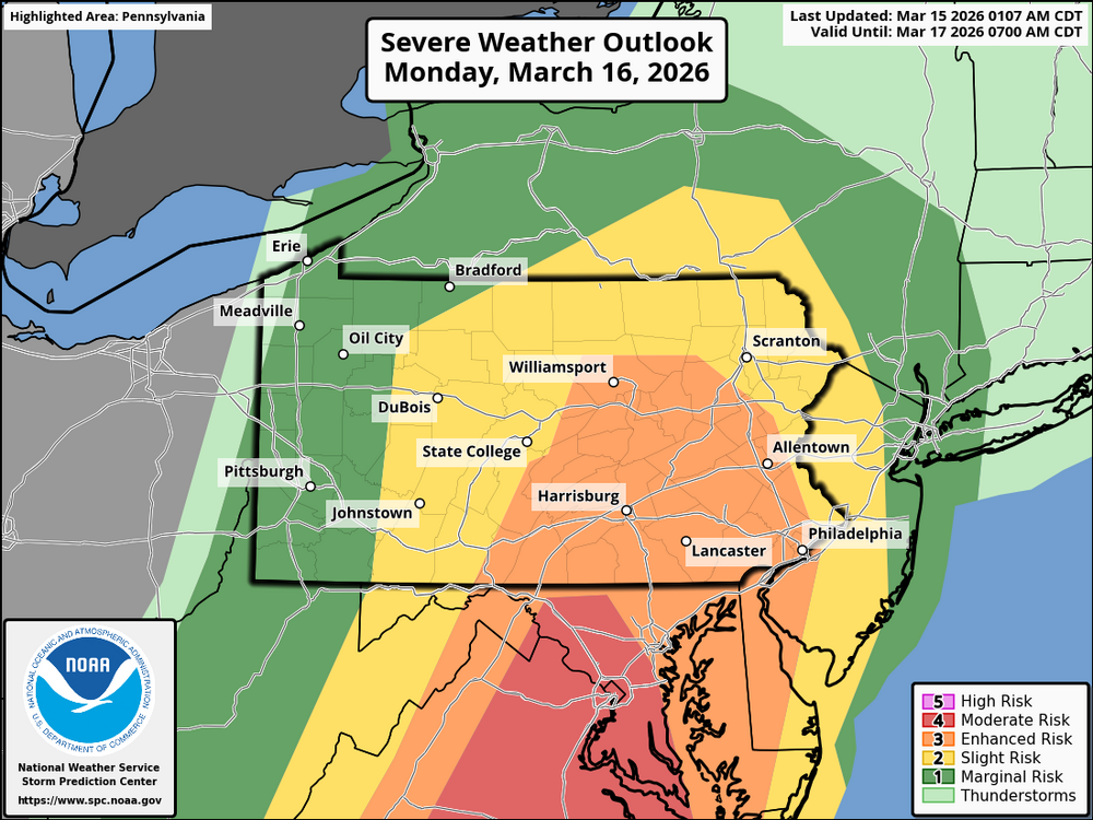
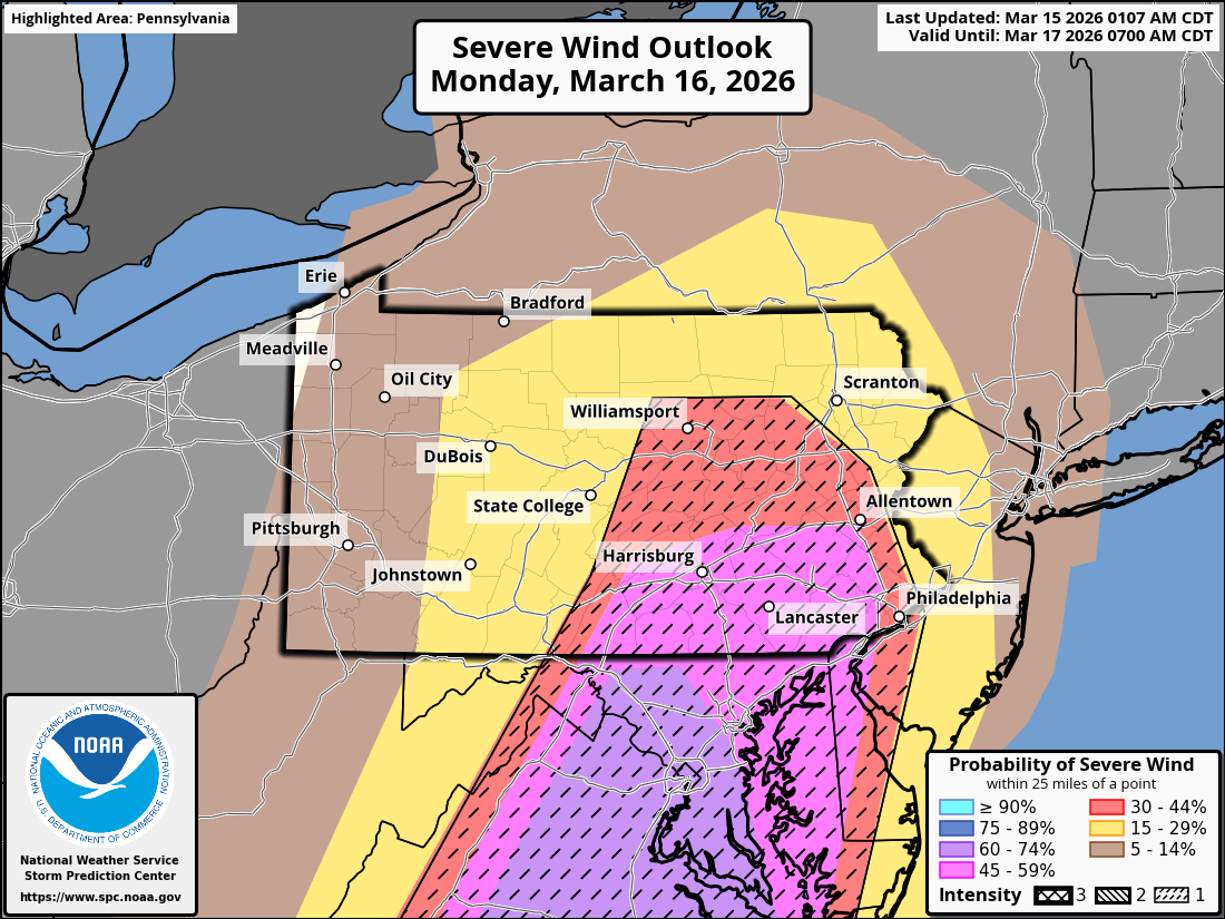
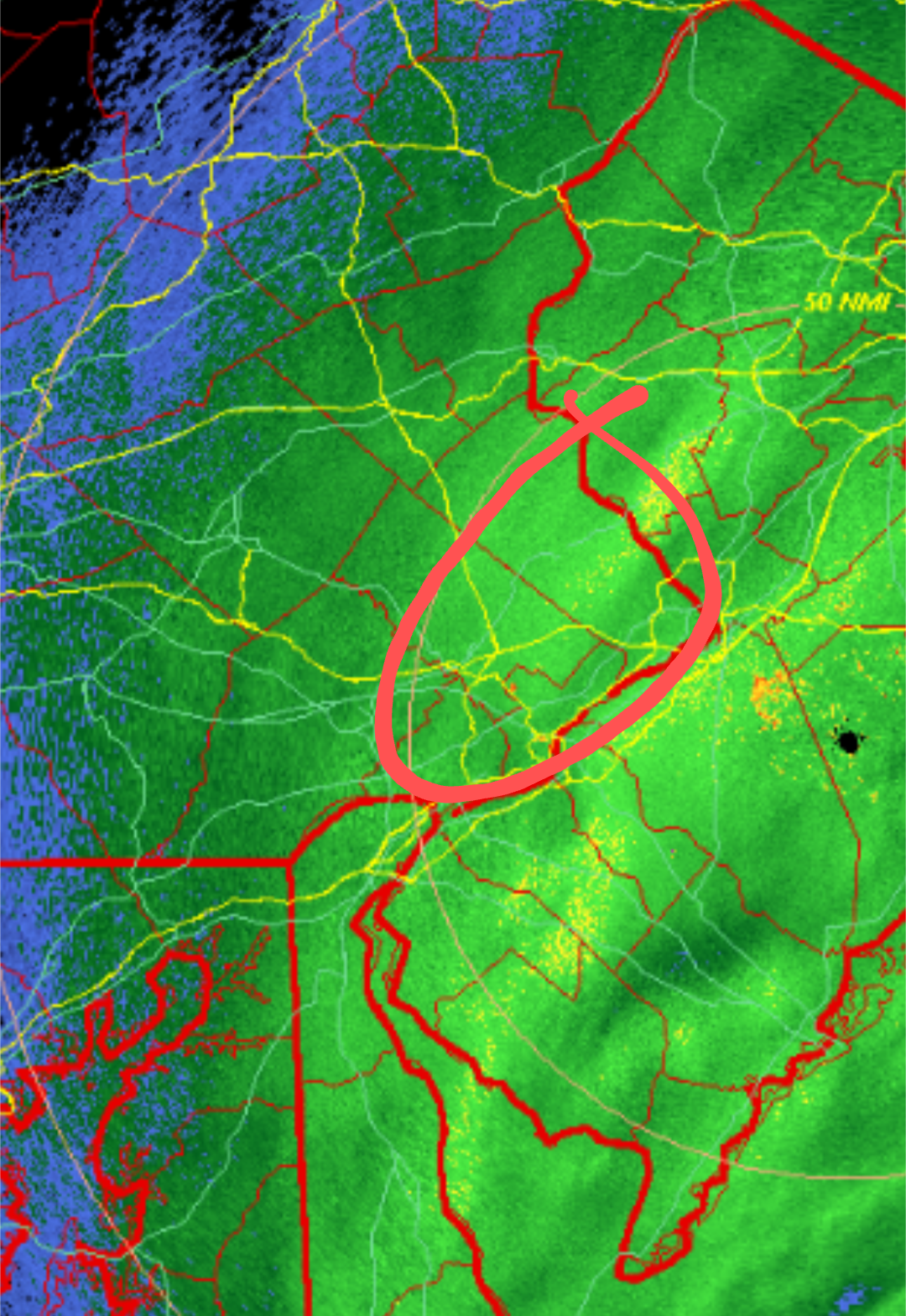
Latest Day 2 from the SPC. 45-60% hatched wind for most, greatest tornado risk is just to the west across south-central PA where a 10-15% hatched risk is outlooked. Given the extremely high shear but low cape environment, damaging QLCS winds will be favored but there will be line mergers and perhaps a few lone cells capable of a stronger tornado. The failure modes I'm seeing are
1. Given the potency of the upper-level trough, there may be "too many" showers and storms developing and competing with each other pre-frontal
2. Early day clouds and showers will limit destabilization
3. Strong southerly winds may or may not create a localized "minimum" in severe weather across SE PA where a narrow marine layer could advect off the Chesapeake Bay
Regardless, we haven't seen a severe weather event of this caliber in at least a few years. It will get very cold again behind the front, so make sure if you lose power you have a plan
.thumb.png.55435d921b680ccfb01912ff0915f3c8.png)
-
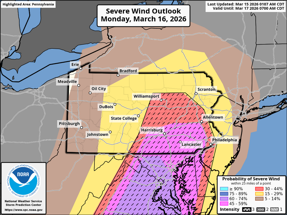
Latest Day 3 from SPC. 45% wind probs just south of the Mason Dixon
.thumb.png.fb6358dc181ffe53ec6f209d086083fb.png)
.thumb.png.c2435568256f1ff38fd1a72900811e15.png)
-
 1
1
-
 1
1
-
-
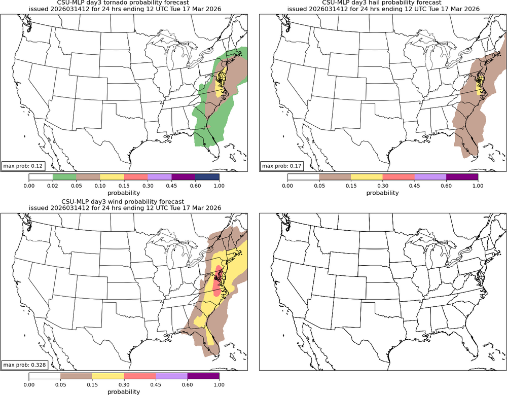
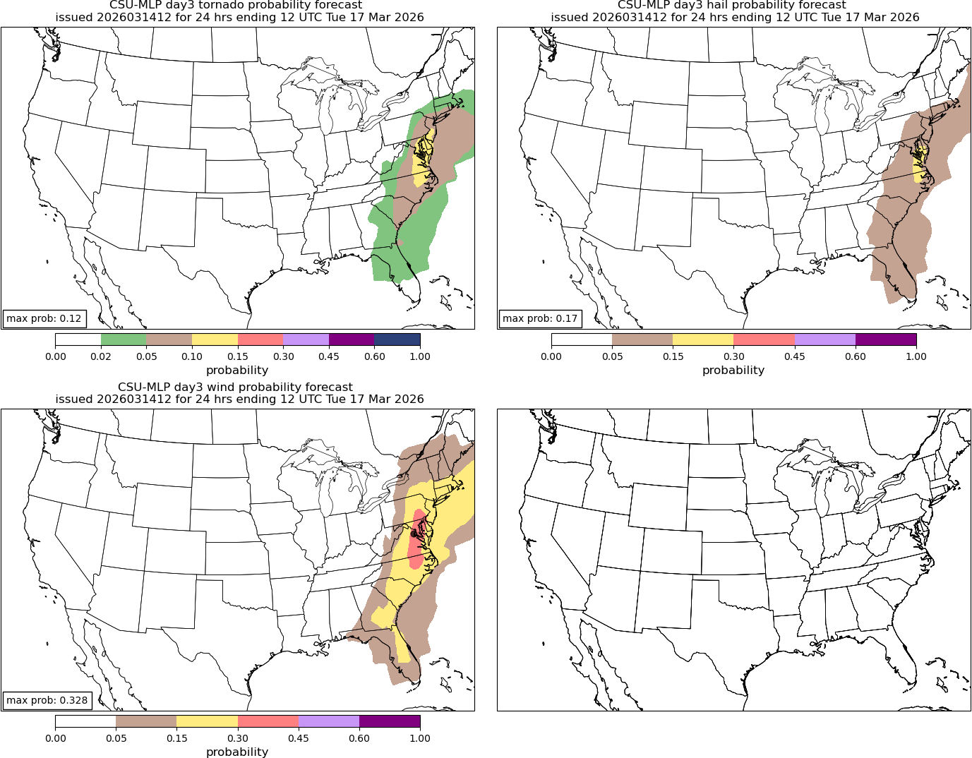
Posted this down in the Mid-Atlantic thread, but the CSU machine learning forecast is still looking ugly for Monday. I do believe the greatest tornado threat will remain *mostly* south and east of the Mason-Dixon, but a damaging QLCS is still nothing to scoff at. Embedded spin-ups a real possibility too. Will need to watch how the system evolves over the next 2 days as there is still a non-zero chance this evolves more into a discrete supercell type event for SE PA. New Day 3 SPC comes out in 30 min
-
1
-
1
-
-
Latest 12z CSU-MLP forecast for Monday

-
5
-
-
9 minutes ago, The 4 Seasons said:
What about Jan 25-26th? That had to be at least a NESIS 2 or 3 maybe higher considering how many big cities were impacted with significant snow. Especially NYC to BOS. That's gotta be coming i would think. I dont see it on the NCEI site yet.
If something like Jan 7th 2022 is on there i have to imagine Jan 2026 will be coming.
They almost certainly have to do a rating for the Jan 25-26th storm, I'm very surprised it's not on there yet. I also just discovered they're including storms that impact areas outside the East Coast? I guess they have always done so if the storm impacts the Northeast in some capacity. December 2022 which was almost entirely uneventful for the East, outside of northern New England, is ranked 4th on the all-time NESIS scale for it's large snow footprint over the upper Mid-West and northern Plains. With that in mind, the January storm should be coming up soon.
-
From the NCEI site:
NCEI is targeting a late-week release for the February 22-24, 2026 snow storm NESIS value.
-
5
-
-
From the NCEI site:
NCEI is targeting a late-week release for the February 22-24, 2026 snow storm NESIS value.
-
2
-
 1
1
-
-
1 hour ago, penndotguy said:
It has been a great winter although out here near Reading we are at 27” for the season so far, one good one before Spring would be great.
Certainly far from a ratter winter, it's been cold and snowy and anytime you hit average snow it's better than most. Another storm though would elevate this season to an A+.
This season was filled with "what ifs". We had probably 3 or 4 storm threats that never materialized, which makes the near to above average snowfall all that more impressive when you consider we missed out on some larger opportunities.
-
2
-
-
1 hour ago, LVblizzard said:
Another failure by the models here. They all had about an inch last night pretty consistently for days. We got nothing but virga and maybe a flurry. This is honestly just as frustrating as a bigger bust because it seems like such a simple setup that just never materialized for some reason.
Same in Fleetwood, not even a dusting.
Seasonal total is so far 34.25 inches which is near average for a winter season. Next Monday could be huge in the final winter grade for Berks.
-
2
-
-
Just now, LVLion77 said:
It’s still snowing in Providence!! 33” thus far. Damn New Englanders have too much of the winter fun.
They actually have 37.9" as of 7pm, shattering their previous record of 28.6. Still snowing as you said
https://mesonet.agron.iastate.edu/wx/afos/p.php?pil=RERPVD&e=202602240000
-
2
-
 3
3
-
 1
1
-
-
-
Also, remember that two things can be true at the same time here. This was an amazing, historic storm for many that lived up to expectations. But also a huge underperformer for others. This was never going to be a 1996 or 2016 that smacked almost the entire region in widespread 1-3 feet.
-
1
-
-
Just now, Chadzachadam said:
I actually think 20" in Philly will be about right, at least if measured properly (clearing snow board every couple hours). but on the ground total will probably be more like 14 or 15"
Gotcha, that's good to know I was looking at the PHL 7am report ha. It came down to wherever that western deformation band set up, which we knew would be the case. The NWS did very with far SE PA, Jersey, and Delaware. But NW burbs not so much. It just is what it is.
-
1
-
-
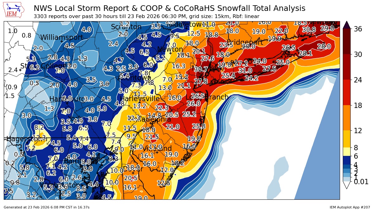
I've actually gotta agree with @LVLion77here. If we take a look at the NWS official forecast from yesterday morning, many many places busted significantly low on totals. I don't have their map right before the storm when they lowered totals, but I know even then they were too high in a lot of places west of 476.
Based on this map: 24" in Mount Pocono? Last I saw they had 4". 15" in Reading? More like 4". Fleetwood was under a warning for 7-14" and we got 5. ChescoWX was in the 18-24" contour and he got 9-10". Even 20" in Philly center city will be too high. Overall Jersey did well, and they nailed the local max along the Jersey coast.
None of this is to discredit the NWS of course, I'm not sure what else they could've done with the data on their hands yesterday morning. I know they'll go back and evaluate what went wrong and what they could've done better. I think there was obviously too much lean on the western NAM/HRRR/FV3 outliers. But the RGEM was ridiculously low on the far eastern side. If you're on this forum, you knew yesterday morning things were shifting back east and that totals would be significantly less so right then your expectations should've been with a modest plowable snow. If I'm the general public in Allentown and I looked at this map yesterday and planned for 15"? Well then yeah, I'd call it a bust. I think the NWS just went too high too soon and then played catch up last second.
.thumb.png.f5256e628261c760b72cc58d3e409bfc.png)
-
3
-
-
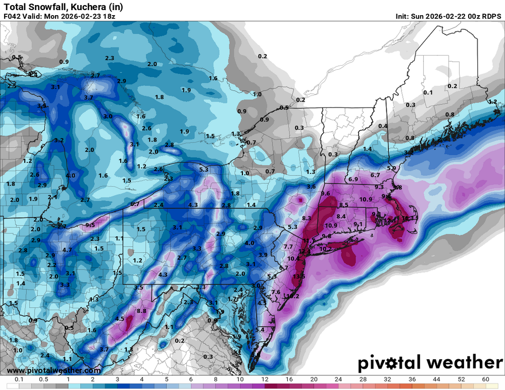
About 5" in Fleetwood storm total. But wow, congrats to all who scored big on this one! Those in SE Bucks County definitely hit the jack on this one as far as totals in PA go. Incredible radar image across southern New England this morning with a firehose band with 6" hour rates in it. Saw a report out of Rhode Island up to 35". Providence RI might break their all time record from 1978
-
5
-
 1
1
-
-
If it wasn't already known, it's looking more and more obvious that this area is going to be the PA jackpot zone. Would not be surprised to see some 20+" reports in there, maybe even some 2 feet reports. Jersey is an entirely different animal, I wouldn't be surprised by a 3-feet+ final total somewhere

-
8
-
2
-
 2
2
-
-
Just looking at my folks front doorbell camera, estimating about 3" or so in Fleetwood? I should mention they are about 5 miles east of the center of Fleetwood up in the "higher" elevations
-
2
-
-
Dusting in Fleetwood thus far, snow is increasing
-
3
-
-
My final call for Berks and Lehigh Valley is 4-8". I think the NWS will begin to trim back on the totals further NW in their next package. All of the western learners (NAM, HRRR, SREFs) are shifting east now as they were (unsurprisingly) too amplified with the trough and mid-level lows. I can see a scenario where parts of this area get screwed between the IVT to the west and CCB to the east. We'll see how the cards are dealt, I hope I'm wrong and areas to the NW get in on the goods. I will say, one way this area could exceed expectations is in the daytime snow today. I will be signing off from the storm for much of the rest of the day, good luck everyone!
-
8
-
2
-
-
7 minutes ago, wkd said:
What map (800, 700mb) would you recommend to see where banding is likely to set up? I use tropical tidbits.
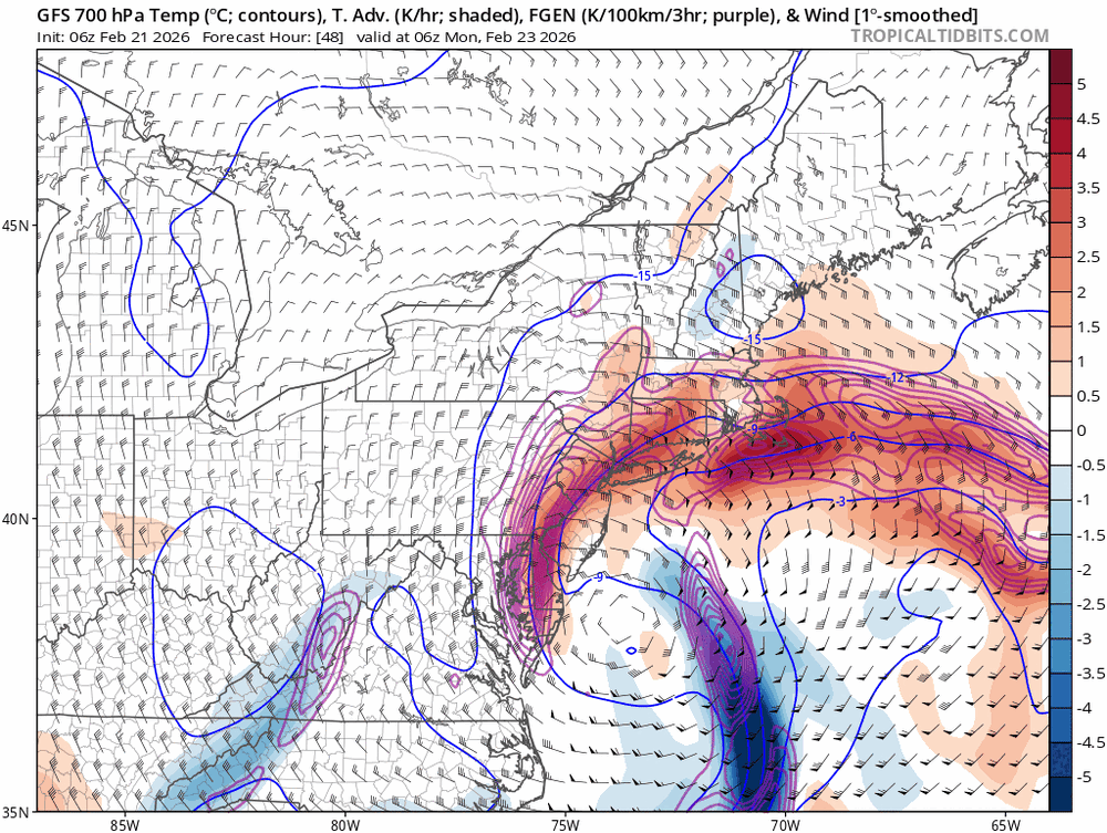
Tropical tidbits 700mb temp advection/frontogenesis as well as the h700 heights/vorticity map.
You can see on the GFS the 700mb fronto band continuing to trend east pretty clearly. But again, it's now casting time. It'll soon be time to watching observations and mesoanalysis as to where the bands actually set up.
-
1
-
-
8 minutes ago, Duca892 said:
Kind of surprised there isn’t more of a concern in this sub about the gradient on the west getting even tighter and shifts east. Unless it’s just more nowcasting than anything
The ticks east in the NAM, GFS, and HRRR guidance are very noticeable, we may start to be seeing Berks/Lehigh on the western fringe now with significantly less totals IF models are right. I'm still inclined to believe banding reaches further west but we will 100% have to now cast with this
-
1
-
-
For NW burbs: the GFS has been ticking east with where the H7 low closes off and how fast it moves/slows down. The small ticks east with that is why areas further NW have been losing some QPF/snow. Again, we just don't know where that will set up right now and 8-16" throughout Berks and the Lehigh Valley is a good call based on current data.
What will happen tomorrow is the precip shield will begin to blossom as the baroclinic leaf expands/PVA rotates into the coast with the trough tilting negative. I would not be surprised to see snow as far back as Pittsburgh. Then, as the mid-level lows close off, the larger precip shield will begin to collapse back towards central/eastern PA as the secondary circulation fronto bands rapidly develop. Also, there appears to be an IVT develop across Central PA. You will likely see a dual band structure with the coastal low: one closer to the coast with 850mb fronto and one further NW with 700mb fronto. There will inherently be some subsidence just outside of those bands. These bands will be rotating off the ocean from SE to NW. Who ever can catch the pivot point of either of those bands will score the jackpot. Even outside of those bands it will be snowing hard.
Now one of the biggest differences between our models remains just how stalled out our surface low gets, and therefore how long those intense frontogenesis bands have time to rotate inland. The NAM remains the most amped outlier and tucks/stalls the system for hours, so these bands can extend much further inland. The RGEM is less amped and quicker, so the bands are quick to depart eastward. In summary, this has nothing to do with the storm track anymore. The differences really come down to how amplified and stacked these mid-level lows get.
-
4
-
4
-
 1
1
-
1
-
-
RGEM is ummm, concerning
-
1
-
1
-
 1
1
-
-
The RRFS would be fun if you're a Berks/Lehigh Valley weenie... 2-4" of snow only LOL. FV3-GFS also went east a bit... Not all of these NOAA meso models should at all be taken seriously though, they don't excel in large synoptic systems
-
1
-

.png.e3cd79f0dec43487032846dd4597a6fa.png)
.png.3acfd92bde1ca3e36aad42d4eef751b2.png)
.png.4fd7f1a9a9844cc4d1b3215161f86adf.png)

.png.45afed66e1ac8edf80e706bc9b471af2.png)

E PA/NJ/DE Spring 2026 Obs/Discussion
in Philadelphia Region
Posted
The wind right behind the low-topped line is gonna roar for some. KLNS is up to 45 mph sustained and gusting to 60 mph. Brother in Lancaster just lost power