

ATreglown
-
Posts
319 -
Joined
-
Last visited
Content Type
Profiles
Blogs
Forums
American Weather
Media Demo
Store
Gallery
Posts posted by ATreglown
-
-
6 minutes ago, alexderiemer said:
This storm went from 0 to 60 in a hurry. Light rain to wind driven heavy sheets in less than 10 minutes
Sent from my SM-G892A using Tapatalk
I am guessing you live in eastern Va then?
-
Just now, ATreglown said:
URGENT - WEATHER MESSAGE
National Weather Service Wakefield VA
1034 PM EDT Thu Oct 11 2018


NCZ012>014-030>032-VAZ075-076-081>083-087>090-092-093-096-512-
516>522-120800-
/O.CON.KAKQ.HW.W.0002.000000T0000Z-181012T0800Z/
Northampton-Hertford-Gates-Bertie-Chowan-Perquimans-Westmoreland-
Richmond-Prince George-Charles City-New Kent-Greensville-Sussex-
Surry-James City-Southampton-Isle of Wight-Suffolk-
Eastern Hanover-Eastern Henrico-Western King William-
Eastern King William-Western King and Queen-
Eastern King and Queen-Western Essex-Eastern Essex-
Including the cities of Margarettsville, Ahoskie, Edenton,
Petersburg, Hopewell, Emporia, Wakefield, Barham,
Gwaltney Corner, Bacons Castle, Chippokes State Park,
Hog Island Game Reserve, Poolesville, Booth Fork, Williamsburg,
Franklin, Mechanicsville, Sandston, Aylett, King William,
West Point, King And Queen Court House, Tappahannock,
and Dunnsville
1034 PM EDT Thu Oct 11 2018

...HIGH WIND WARNING REMAINS IN EFFECT UNTIL 4 AM EDT FRIDAY...

* AREAS AFFECTED: Much of southern and eastern Virginia and
  portions of interior northeast North Carolina.

* HAZARDS: Strong or damaging wind gusts.

* WINDS: Winds shifting to the north to northwest at 30 to 40 mph
  with gusts to 60 mph into early Friday morning.

* TIMING: Into early Friday morning. Winds will gradually
  diminish after 4 am.

* IMPACTS: Strong wind combined with heavy rain will cause
  downed trees and scattered power outages.
I know it says southern Va, but some areas listed are not southern Va. Some are central Va.
-
URGENT - WEATHER MESSAGE
National Weather Service Wakefield VA
1034 PM EDT Thu Oct 11 2018


NCZ012>014-030>032-VAZ075-076-081>083-087>090-092-093-096-512-
516>522-120800-
/O.CON.KAKQ.HW.W.0002.000000T0000Z-181012T0800Z/
Northampton-Hertford-Gates-Bertie-Chowan-Perquimans-Westmoreland-
Richmond-Prince George-Charles City-New Kent-Greensville-Sussex-
Surry-James City-Southampton-Isle of Wight-Suffolk-
Eastern Hanover-Eastern Henrico-Western King William-
Eastern King William-Western King and Queen-
Eastern King and Queen-Western Essex-Eastern Essex-
Including the cities of Margarettsville, Ahoskie, Edenton,
Petersburg, Hopewell, Emporia, Wakefield, Barham,
Gwaltney Corner, Bacons Castle, Chippokes State Park,
Hog Island Game Reserve, Poolesville, Booth Fork, Williamsburg,
Franklin, Mechanicsville, Sandston, Aylett, King William,
West Point, King And Queen Court House, Tappahannock,
and Dunnsville
1034 PM EDT Thu Oct 11 2018

...HIGH WIND WARNING REMAINS IN EFFECT UNTIL 4 AM EDT FRIDAY...

* AREAS AFFECTED: Much of southern and eastern Virginia and
  portions of interior northeast North Carolina.

* HAZARDS: Strong or damaging wind gusts.

* WINDS: Winds shifting to the north to northwest at 30 to 40 mph
  with gusts to 60 mph into early Friday morning.

* TIMING: Into early Friday morning. Winds will gradually
  diminish after 4 am.

* IMPACTS: Strong wind combined with heavy rain will cause
  downed trees and scattered power outages.
-
THE FLASH FLOOD WARNING REMAINS IN EFFECT UNTIL 130 AM EDT FOR
NORTHWESTERN KING AND QUEEN...NORTHWESTERN CHARLES CITY...
NORTHWESTERN NEW KENT...HENRICO...KING WILLIAM AND SOUTHEASTERN
HANOVER COUNTIES AND THE CITY OF RICHMOND...

At 841 PM EDT, Doppler radar and automated rain gauges indicated
that heavy rain was falling over the area. Nearly 3 inches of rain
has fallen at the Richmond International Airport. Over the warning
area, an average of 3 to 5 inches has fallen with locally higher
amounts. Numerous roads are closed and water rescues are ongoing
within the City of Richmond.

Some locations that will experience flooding include...
Richmond, King William, Virginia Commonwealth University,
Talleysville, Highland Springs, Downtown Richmond, Virginia Union
University, University Of Richmond, Saint Stephens Church, Roxbury,
Mechanicsville, Bon Air, Tuckahoe, Tunstall, Manquin, Beulahville,
Laurel, Mangohick, Bensley and East Highland Park.
-
20 minutes ago, WxWatcher007 said:
Thanks for sharing your observations! Good luck getting power back!
Welcome. Who knows when that will be. All it took was the second gust and boom, power went out. Lots of power outages across the state. VA Power map shows 234,380. I am with PGE coop, they do not have a map, so I have no idea when it will come back on. i'll turn on the generator when it settles down. Schools in the area are closed tomorrow because of storm damage and with it being Friday, probably will not be in that big of a hurry.
EDIT: VA Power updates every 15 minutes and is now up to 245,704. That went up quite fast!
-
 1
1
-
-
Lots of heavy rain, about 3.5", and winds have howling. Sustained around 30 mph with gusts anywhere between 45 and 58 mph. I am 25 miles south of Richmond. Lost power at 8:15 pm. Michael is putting on a show here. Too bad it had to happen at night.
-
1
-
 1
1
-
-
23 minutes ago, MattPetrulli said:
Flash Flood Emergency for most of the area covering the training band, including Jacksonville. Pretty strong wording
* At 1029 PM EDT, emergency management reported extremely heavy rain
across the warned area associated with a nearly stationary rain
band from Tropical Storm Florence. Since yesterday 10 to 18 inches
have fallen across the area. Life threatening flash flooding is
occurring with numerous impassable due to high water. It is
imperative that residents remain off the roads, and only venture
outside if there is a threat to your well being. Additional
rainfall amounts of 5 to 10 inches are possible tonight across the
warned area.This is a FLASH FLOOD EMERGENCY for portions of Jones, Lenoir,
Onslow, and Duplin counties. This is a PARTICULARLY DANGEROUS
SITUATION. SEEK HIGHER GROUND NOW!Been a lot of flash flood emergency statements going out for this part of eastern NC for all this later afternoon / evening hours. That heavy band of rain set up in the one of the worst areas of ENC and has pounded that area for so many hours! Just devastation!!
-
150 people need rescue according to this New Bern twitter account. Also reported by Fox News.
-
3 minutes ago, jacindc said:
Someone posted somewhere a link to a Twitter list of mets, officials, etc.--anyone have that?
-
2
-
2
-
-
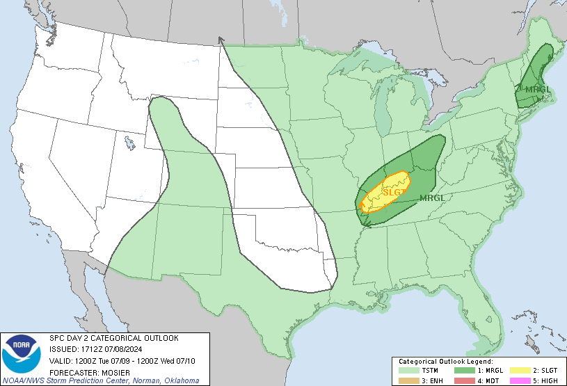
From NWS Wakefield:
Latest Bufkit soundings depict curved hodographs profiles with
strong SSE low level flow (50-55kt @ 950mb) and strong SSW flow
aloft. The limiting factor will be minimal sfc-based instability
with the timing during the nighttime hours Sun night (early Mon
am)...and a relatively substantial stable layer across far
eastern VA and the Eastern Shore. Again, greatest threat will
be strong gusty winds getting mixed down within convective cells
along with potential for brief, heavy rainfall. Must also be
noted that 0-1km shear profile is actually quite impressive,
quickly increasing to 30-40kt after 00z/MON. Therefore, we still
cannot rule out the potential for a couple of rotating storms
capable of producing brief spin-up tornadoes, with greatest
concern along and SE of I-64 across central and eastern VA
(including RIC metro/Tri-Cities area).
-
-
Heavy snow here in Prince George. Started around 1pm or so, but it took a couple of hours to begin to stick. The yard is almost covered with temperature at 33. Roads are only wet and I live in a rural area. I think it is just a matter of time before the roads cave as we move into the evening hours.
-
1
-
-
1 minute ago, ATreglown said:
240% climo and it gets an A-. I would say that is as A+!!!
I know I am extremely happy with snow in PG, VA this year!! It has exceeded my expectations!! To have 3 nice events, one being 8" by Jan. 17th, I will take any given year, and try not to complain the next year!
-
5 minutes ago, SteveVa said:
About 2" give or take on the ground near town center of VB. No precip currently but as the snow hole over the area is filling in I believe we'll be able to get another inch, or maybe 2" on the high end.
This event will likely push the total for the season over a foot for ORF...or about 240% of climo. I give this winter an A-
240% climo and it gets an A-. I would say that is as A+!!!
-
6 minutes ago, Cobalt said:
How much did you get from this event?
Got right at 4". It has snowed from 7:30ish this morning till now, but the tiniest flakes ever. We had a lot of moderate snow, but just took forever to accumulate even at 28*.
-
I am happy with snowfall today. Puts me at 17" for the season, well above average with still half the season to go. Hopefully we can continue this into the second half! But, looks like we have a bit of warm to deal with first.
-
4 minutes ago, SteveVa said:
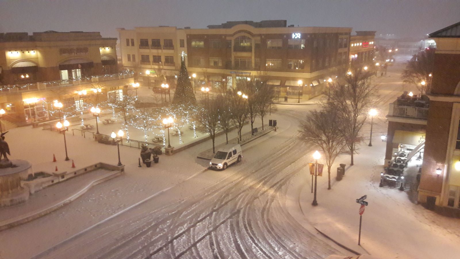
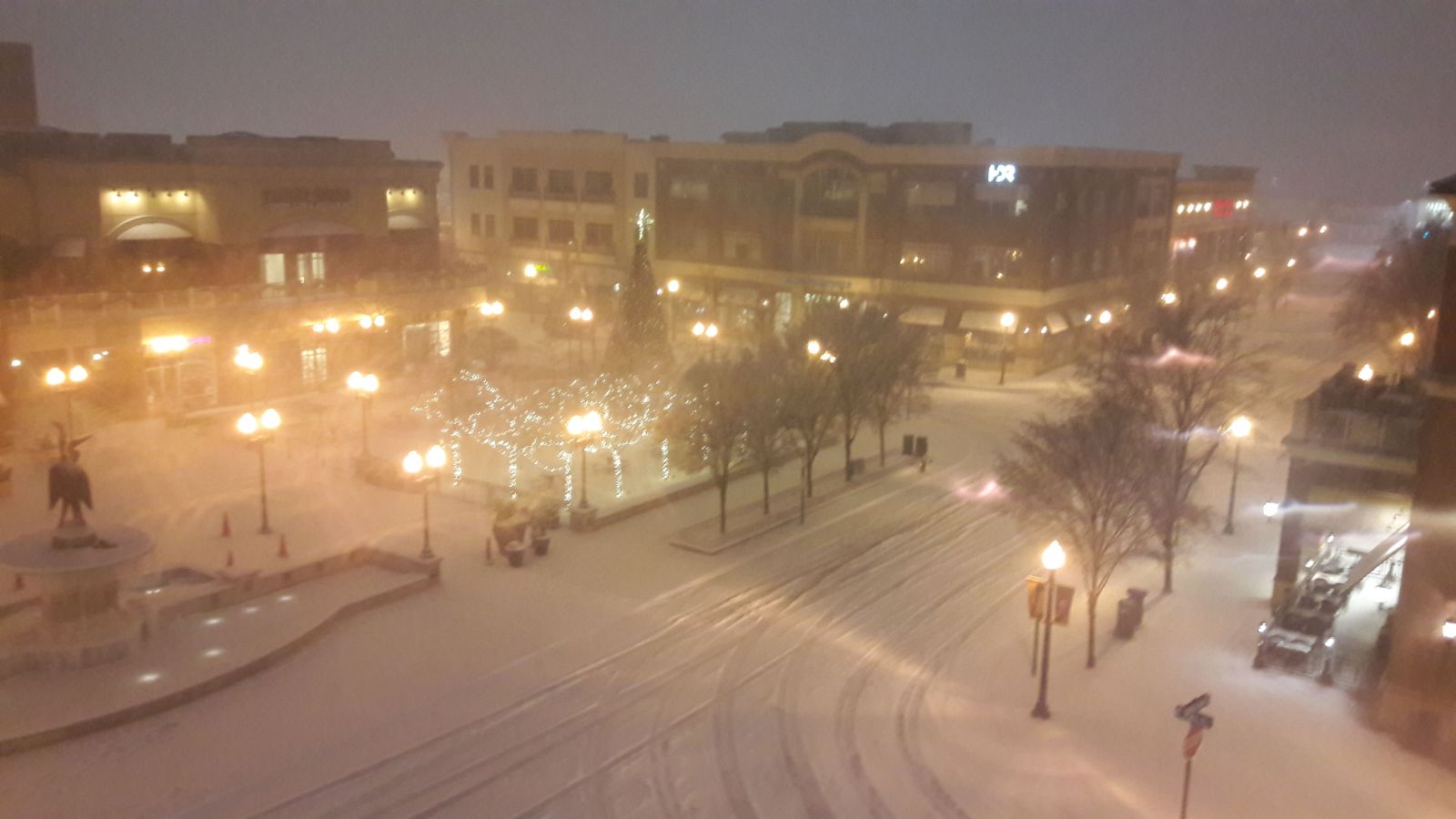
Blizzard conditions in Va Beach with winds gusting into 40s, I drove around for an hour and there is a noticeable uptick in snow as you pass Rosemont. Probably getting close to 4".
Here is a picture from 10:30 pm and 12:30 am. They're bad quality because it's hard to take good pics in blizzard conditions lol
10:30

and 12:30

Nice photos!!
-
1
-
-
Just by eye balling it, looks to be around 2" so far. Coming down hard right now!
-
Down to 984 MB.
-
Yep, it looks like half an eye. Jan. 2000 had that cane look too.
-
Just now, ATreglown said:

Theta-E changes over the past six hours pointing the way. Intense system. Pushing into the MIDATL coastline. Heavy snow shortly.
From Cranky
-
-
Heavier band approaching Prince George (PG). Approaching 1.5". 26/24.
October Discobs Thread
in Mid Atlantic
Posted
My bad. I thought I read that you moved from Cali to Va. I figured it was east though with your winds finally ramping up. Here, it was just rain and I was seeing reports very near by with high wind gust, but nothing at my location. But a few minutes later it was like a switch was flipped and the winds started roaring and my power went out immediately. Going to wait and turn the generator on when I get up around 6:30, pretty sure there still will be no power. It's already late, so I figure why bother. Frig will last till then.