

Stormman96
-
Posts
165 -
Joined
-
Last visited
Content Type
Profiles
Blogs
Forums
American Weather
Media Demo
Store
Gallery
Posts posted by Stormman96
-
-
3 minutes ago, RedSky said:
? It gives me 1" more than the the November storm, as in 1" total
It's ok GFS #2 will have a completely different solution at 12:30
Where are you at?
-
1 hour ago, Snow88 said:
December still might be stormy and cold but not the first week.
Starting to get that worry feeing. Last week I kept thinking this is a bad sign for winter lovers that we are getting an early season snowstorm. Usually in past more often then not leads to snowless winters. Even while at sametime everyone was saying how good pattern was looking to end November and start December. Kept hearing from multiple sources that we would have a high chance of 2 or more winter storm threats in first week of December. Now things are already changing and not looking so promising early December. Now im hearing perhaps mid to late December this reminds me of a winter in the past not sure what year. But kept hearing cold an snow was coming. It was always 2 more weeks. Next think I knew it was april. Just venting. But hopefully thats not the case this year
-
Wow looks like another 1-2 fell overnight on top of the 7.5 I measured in the early evening here. So final total about 8-9 here in quakertown
-
Measured around 7.5 in quakertown. Way over performed
-
I think the fact how much this storm over achieved is a good sign this winter will really be an over achiever as well
-
Wow. Dt going 4-7 for my area in quakertown through Lehigh Valley
-
35 minutes ago, RedSky said:
3-5" SEPA is a significant and rare event for the first half of November if it happens. Never mind the fantasy runs of a major snow the para GFS and Euro printed out the last couple days this would be a great start to winter.
Where in se pa do you see 3-5 snow ? Im in quakertown area. An even here looks like very little snow an mostly sleet
-
15 minutes ago, CarLover014 said:
In my opinion, I think this might be reasonable through Thursday night, before it turns over to rain. Likely going to be in the 3 - 5 : 1 range.

Still way overdone philly not getting 2.4 snow
-
1 minute ago, CarLover014 said:
12z FV3-GFS cut back a little too.


Sucks i only get 17 now. Lol these models are all awful
-
 1
1
-
-
13 minutes ago, The Iceman said:
Not a pro but here is what I think basing off of analogs, the seasonal pattern thus far, and the long term pattern over the last decade or so. Now that enso is more clear, I am more confident in my thinking. Analog years are 63-64, 77-78, 86-87, 02-03, 14-15. Now you may see this and think oh man, Iceman is about to drop another winter of yore forecast...but not so fast. This winter should feature an active storm pattern similar to what we have seen in the last few weeks frequently featured in a 'modoki' el nino. Modoki el nino are typically prolific snow makers in the interior and in the Northeast and I feel like this winter will be no different. However, down in the 95 corridor and burbs, modoki's are not as much of a lock to be big years but usually do work in our favor if the atlantic is cooperative. Now usually anytime you have above average precip and around normal temps, the area typically sees above average snow fall. And I think those 2 of those 3 things will be true this winter. Unfortunately I do not think the snow part will come together more often than not for 95. I'm thinking the pattern of late will be the theme of winter. Progressive systems that will be prolific moisture makers but will need to thread the needle in order to produce snow for 95. As we have seen, and will see later this week, a lot of time these patterns produce storms that either hug the coast or cut up the apps. I do not foresee a -NAO being long lasting based on my personal belief that the NAO is largely in one phase over 20 year periods and right now we are in a +NAO regime. Now I think we will have periods with a -NAO but I do not think it will be the dominant feature this winter. Now due to this, we will largely be trying to thread the needle on the coastal plain which works against us more often than not. One storm can bust my entire snow forecast but I do think largely this will be a winter of changeover events for the 95 corridor. As a result, even though precip will be above normal and temps likely around normal(as behind these systems we will see temps below normal), I think this winter will be at or below average snowfall for the 95 corridor. For the area around the NE extension N and W, I think this winter will be a good one. Above average for sure, potentially an all timer. Here's the month by month breakdown:
Dec
Temps 0 to -2
Precip: Above Normal
Snowfall: Normal for 95 corridor, Above normal N and W burbs(Northeast extension and north)
Jan
Temps +1 to +3
Precip: Above Normal
Snowfall: Normal 95, above normal N and W
Feb
Temps 0 to +2
Precip: Above Normal
Snowfall: Below Normal 95, Normal N and W
Thanks for reading!
Good forecast. No complaints here since im in quakertown area so should be good. Just find it interesting that most years s the pros on the news dont hype the winter and then I come on here an all the amateurs call for hugh winters. This year the big wigs in the news are all hyping a great winter especially hurricane basically saying every single ingredient he looks at points to a snowy winter for everyone. Then I come on here an several amateurs are calling for a not so snowy winter. Just interesting
-
9 minutes ago, Birds~69 said:
These winter predictions from our local outlets are out earlier than normal I believe? Are they that confident?
Not really they are always out the week before thanksgiving
-
1 minute ago, RedSky said:
Winter of Yore is upon us
And ofcourse just saw our favorite weather women on nbc10. Said no snow will make it into philly maybe a quick mix well nw of philly
-
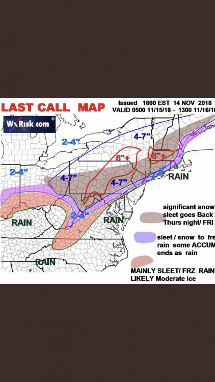
5 minutes ago, LVblizzard said:
12z Euro went nuts for Thursday. Solid 4-8” plus freezing rain NW of I-95
Seriously? Any maps?
-
4 minutes ago, Eskimo Joe said:
Cant find anything to be concerned about with respect to the upcoming winter. Dont think it's going to be cold, but really hopeful at the prospect of one or two good storms. Hell, a climo year would be better than the last 2 winters.
Huh??
-
Im surprised nobody mentioned it but here was Abc6 winter outlook
https://6abc.com/weather/cecily-tynans-winter-weather-outlook/4651196/
-
Glenn schwartz Winter outlook. Going warm an little snow. No big storms at all

E PA/NJ/DE Fall 2018 OBS Thread
in Philadelphia Region
Posted
That sucks so your not still up in quakertown area? We got hit pretty good here