

Stormman96
-
Posts
165 -
Joined
-
Last visited
Content Type
Profiles
Blogs
Forums
American Weather
Media Demo
Store
Gallery
Posts posted by Stormman96
-
-
4 minutes ago, ChescoWx said:
Never saw him before.....then again I never watch TV weather folks - just happened to pass by as my wife was watching
Prob drew anderson?
-
6 minutes ago, LVblizzard said:
It’s raining in Allentown so I highly doubt it’s snowing in KOP.
Yes didnt think so im in Quakertown an raining
-
3 minutes ago, CoolHandMike said:
Unless snowing while it's 41°F is a new thing, no, it's not snowing in KoP atm.

Didnt think so
-
The new reported it was snowing already in kop can someone confirm cant believe it would be snowing this early
-
5 minutes ago, anthonyweather said:

.Wow hope this is correct i will take my 5-10
-
17 minutes ago, Blizzard-on-GFS said:
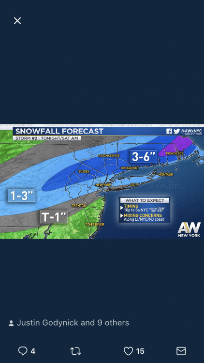
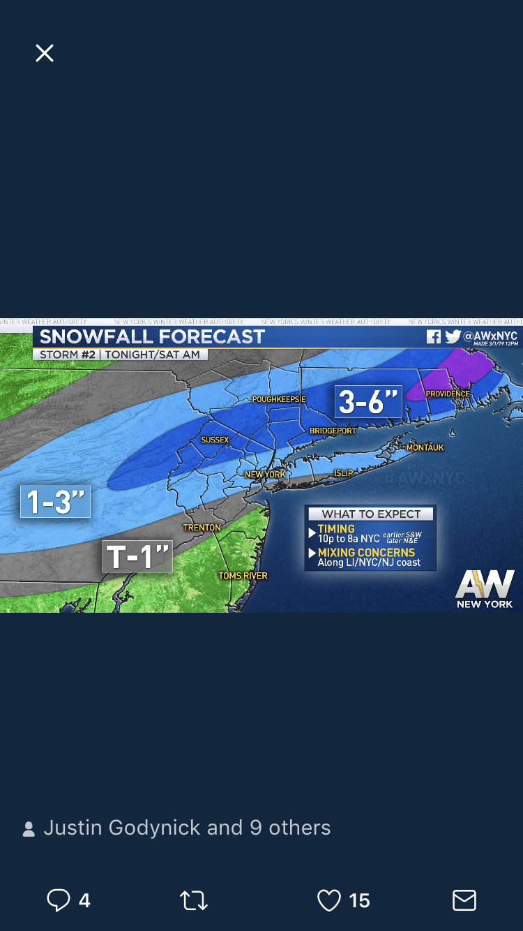
That 1-3” zone is going to bust terribly. Should be at least 4-8”
Too warm for 4-8 in city
-
 2
2
-
-
37 minutes ago, penndotguy said:
It doesn’t if ya read the watch it says it will be converted to a WWA
I did read it it says if warning level snows arent reached it will be converted so while issue it in first place
-
1 hour ago, penndotguy said:
Winter Storm watch posted out here in Berks, 2-4” likely be converted to a WWA Tomorrow evening
Winter storm watch for upper bucks for 2-4 didnt even think that reached the criteria
-
1
-
-
22 minutes ago, Eskimo Joe said:
Not looking good in the medium to long term for snow either. It's been torture for snow lovers since the winter of 2014-2015.
How so? Didnt we get a pretty big storm feb 2021 Also multiple nor easters march 2018 also a big storm jan 2016???
-
1
-
-
3 hours ago, Birds~69 said:
26" for Philly from FOX29....
Yes 19-26 for philly. But how can they be so confident their wont be any 12+ storms.
-
52 minutes ago, Birds~69 said:
FOX29 going with 25"-30" for Philly...
This isnt their official winter outlook. They said they will be all given outlook in coming days
Channel 6. Gave theirs last night
going 18-24 in Philly
30-36 in lehigh valley
-
1 minute ago, hazwoper said:
the trend is your friend for tonight my friends
")
This doesnt look great to me
-
Glenn schwartz Winter outlook. Going warm an little snow. No big storms at all
The Official Unofficial Overnight February 16/17th Snow/OBS Thread
in Philadelphia Region
Posted