
rduwx
-
Posts
2,729 -
Joined
-
Last visited
Content Type
Profiles
Blogs
Forums
American Weather
Media Demo
Store
Gallery
Posts posted by rduwx
-
-
5 minutes ago, PantherJustin said:
NAM review = Womp Womp all you need to know
The NAM didn't end up being terrible. Not some of the bombs we saw on yesterday's 18z runs but still not terrible.
-
5 minutes ago, Brick Tamland said:
Looks like the NAM might have more precip farther west this time.
Precip didn't really expand west on the 18z nam. There is more precip to the south. I would expect amounts in the RDU area to be close to 12z.
-
Just now, burgertime said:
March 2009 comes to mind for me. ULL was all over the place and then at the last second folks along I-85 cashed in.
I remember that storm. We've been around to see some bad trends.
-
2 hours ago, NorthHillsWx said:
For once I’d like to know what a positive trend inside 48 hours feels like
I was thinking about this earlier. I believe I've seen every bad trend there is since I started this hobby almost 20 years ago but I don't think I've ever had a positive trend. This one ranks up there as far as gut punches though...LOL!
-
 1
1
-
-
How do I always end up in this thread after tracking storms for a week?


Of course this is just a little humor to try to lighten the mood a little. A few inches of snow with these temps will still be fun. Of course I would prefer what models were showing yesterday but trends this morning aren't headed that way.
-
3
-
-
6 minutes ago, burrel2 said:
Probably worthless but the 12zjma is still phasing and throwing precip way back west
Looking at the 12z euro ens members, I'd say several are still showing a phase with the amount of moisture in the western part of NC.
-
2
-
-
2 minutes ago, ILMRoss said:
One thing I'd like to add- I think sometimes everyone (mets, hobbyists, whoever) can fall into the pitfall of humanizing models too much- I see some "I trust the Euro over everything" like the Euro is a close friend you've been gossiping with, or "the GFS has been hot this month" as if the GFS is Klay Thompson. This isn't a message saying not to rely on models for known strengths and accounting for known biases- but at the end of the day every model is just a supercomputer taking in data, running it through different recipes of the same planetary laws and equations, and spitting stuff out and I think it's good not to get too caught up with the narrative behind each model.
Goes back to the old saying, "meteorology over modelogy"...LOL!
-
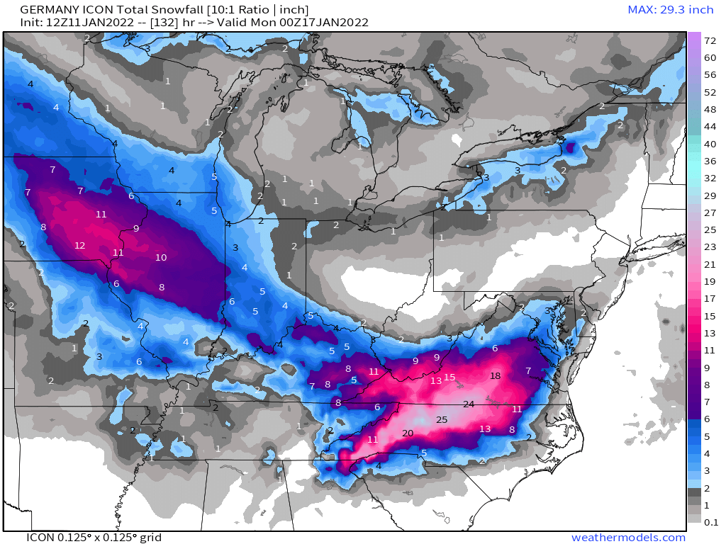
Even though I don't have much confidence in the ICON, for those in central to eastern part of NC, this is the type of track and strength we'd like to see. Haven't seen snow totals but would expect higher totals for the RDU area. I do believe there would still be some mixing but not near as much.
-
1
-
-
17 minutes ago, Brick Tamland said:
I wonder if the Triangle is going to have to get used to seeing the warm nose more and more. It certainly seems to come further west and north than it used to. Greg Fishel said something with the last snow storm that the air coming off the ocean makes it warmer in the Triangle and harder to get snow than west of the Triangle. I think the more we see the oceans warming the more we'll see this happening and the warm nose continue to increase further west and north when we have a winter storm threat.
I know over the past 20 years of tracking storms for this area that the warm nose is always under modeled. I'm not sure the reason but there have been many times models showed all snow and I had mixing issues. Just the area we live in. I'm looking forward to a possible storm this weekend but I believe it's always best to count on mixing issues for the RDU area. Therefore you're not surprised when it happens. Not necessarily directed at you Brick. The good news is the mixing makes for some good sledding weather. Yes, 52 years young and still go sledding with the kids...LOL!
-
1
-
 1
1
-
-
1 minute ago, StoneColdWeatherAustin said:
On the GFS control/mean graph, am I reading it correctly that it shows another storm about a week later ?
Yes, 12z showed another system for Friday 1/21.
-
1
-
-
38 minutes ago, Brick Tamland said:
I have a feeling that between tomorrow and Sunday we're going to see the areas of heavy snowfall expand further north and east. I think in NC 95 down to 42 through Clayton, Fuquay, and Sanford will be the transition zone.
Surely possible. I will say with the more amped solution, the warm nose for our area is going to be an issue. If history is a factor, then the warm nose is always under modeled. I've seen it so many times over the years.
-
1 minute ago, burgertime said:
CMC is quicker with the energy out to 78.
I peaked at the old black and whites and it appears to be a WNC special also. LP tracks slightly inland like the 12z gfs. Hopefully better maps will give more detail.
-
1 minute ago, CaryWx said:
Heck, even we'd need it a little east in Cary
Yes, I agree. Not putting a lot of stock in the ICON on the placement. Hopefully we don't see this in future model runs.
-
8 minutes ago, NJsnow89 said:
Slide those heavy totals towards the east a bit! Moved to Wilson, NC recently from NJ and would love to see some snow here.
For higher totals in Wilson, you need the LP off the coast to be further east of the location showed on the ICON. If you noticed the map Wow posted, the LP is right on the coast or slightly inland. Need that a little east.
-
1
-
-
-
5 minutes ago, Buddy1987 said:
huh? 99hrs it is well west of the 6z run
It turned out a lot better on the sfc than I was expecting watching the 500 maps. LOL!
-
2
-
-
The wave dropping south appeared to be a little east of previous runs on the ICON. We need the wave to be a little further west as it drops down so it has time to make the turn. Hopefully we don't see this in future model runs today.
-
2 minutes ago, burrel2 said:
Sorta like that look 6 days out. It seems like these systems always tighten up and amplify a little better once we get inside 72hrs.
Agreed! I'll take having this look 6 days out anytime! LOL! Of course I'm hoping for more qpf to show up in future runs.
-
1
-
-
12z euro was more strung out and tilt wasn't as close to neutral. Just one run and lots of time for this to change but these are things we need to see improve moving forward for more qpf imo.
-
1
-
-
22 minutes ago, btownheel said:
How does that map happen? Did the Charlotte corridor just catch a stalled band? I was a sophomore at UNC at the time and remember that storm well but had no idea it dropped up to 20 inches 50 or less miles from me.
.If I remember correctly, it was an upper level low and the deform band dumped snow in one spot.
-
5 minutes ago, jburns said:
Yep. Less than 15 miles to the north the airport got a total of 6”. EDIT: As I remember it. Could be an inch or two either way.
I also remember being jealous!

-
 1
1
-
-
2 minutes ago, jburns said:
Feb. 27 eh. Interesting. It can happen. This was my backyard on Feb 27, 2004. I had accumulated around four inches during the day but this is the 20” I ended up with after more than three hours of unbelievably heavy thunder snow. It wasn’t just rumbling thunder in the distance. Some of the flashes lit the yard like daylight.
I could stand a repeat.

If I remember correctly, that was an upper level low where the deformation band set up over you for hours.
-
Any other models showing this storm? I didn't purchase the model suite this year and have to admit, it feels good asking that question. It's probably been since 2005 since I've asked that...
We do have weekend rule on our side.

-
1
-
-
2 minutes ago, BornAgain13 said:
Lol , GFS showing a 16-24" Snowstorm for NC and VA next Friday/Saturday
I laughed at this so it'll probably happen...LOL!
-
1
-
Potential 1/28-1/30 2022 winter storm
in Southeastern States
Posted
No problem. I will say I didn't like some of the things I saw at the 500 level. It looked to my amateur eyes that it took a step towards the what the gfs and euro showed at 12z.