

wolfpackwxDC
-
Posts
109 -
Joined
-
Last visited
Content Type
Profiles
Blogs
Forums
American Weather
Media Demo
Store
Gallery
Posts posted by wolfpackwxDC
-
-
13.8 / 7 west Arlington
Dewpoint up a degree in the last hour.
-
 2
2
-
-
Anecdotal analysis...

15z backyard model run: Squirrels are out in force this morning, digging all over the place, despite it being 25 degrees. Much more active than over the past week. Perhaps they know something...
-
4
-
 4
4
-
 1
1
-
-
3 minutes ago, Weather Will said:
What is the criteria for an ice storm warning?
Some of these criteria vary from region to region, but here is what LWX has on their site. Looks like .25 inches of ice.
-
 1
1
-
-
24 minutes ago, Bob Chill said:
That low jump is just a digital thing from what I can tell. Model graphic output is programmed to stamp an L at the lowest pressure but the lowest pressure is fluid so the L jumps around inside the "bag of low pressure". I like using the shaded mslp anomaly maps to just compare the bigger bag (general center) and not the L (specific center). I could be wrong here so someone correct me if so
I always find it odd that people live and die based on where contours are closed and letters are drawn, especially if run to run they move +/- 25 miles.
-
2
-
-
1 minute ago, SnowenOutThere said:

Geez, look at the north south line.
Caroline County - big winner here!
-
Just now, kristia said:
That would be me. Have a great generator. It’s the trees that worry me.
I balked on buying a generator after 2 big storms knocked out power here in Arlington last summer. Lights flickered during the snow last week. I think we will be getting said generator as soon as we can secure one!
-
1
-
-
1 minute ago, Paleocene said:
I live inside the DC beltway (and I have since 2011) so my expectations for what we can get in any storm are realistic. I will be happy if we get even 2" of snow falling in the late afternoon Sunday so I can go outside with my kid before it gets dark and have some fun. Sure it sucks we aren't getting HECS'D, but the trend has been clear on this one since Tuesday. That's OK, it's been a good January so far. Ideal scenario = snow--->sleet---> drizzle. Hoping the euro can lock in that solution.
I am with you - same location, same situation. With a 3 year old, unless we get a HECS, give me enough to enjoy Sunday and Monday. Then, the damn roads better be clear for Daycare dropoff on Tuesday morning!
-
3
-
-
1 hour ago, jayyy said:
I know NAM gets trashed, which is usually pretty spot on when we’re talking about 60-84 hours, but if the 12k and 3K are showing a major ice storm at the 24-48 hour mark, we need to be paying attention, as the NAM is better at picking up mid level warming in these setups than the GFS.
I am with you. I have been out all morning, running errands at IKEA and Costco because I hate myself, but just catching up on things and I really think we might be underplaying the ice threat. Sure, 100% agree on the initial thump of snow, but as I have experienced in many a winter setup in eastern NC, you can have 2-3 inches of snow, followed by .25 - .5 inches of ice and those storms were the freaking worst. Feel like the threat is more aligned with the Rt. 15 corridor, just west of the city - but who knows.
I sold my soul Wx soul for more money and a better commute, so my model analysis eyes are probably garbage at this point
-
6
-
1
-
-
Went to the store today for my normal, weekly run and got the last 1/2 gallons of milk. Employee said they were full an hour before. Guess people must be getting the message
")
-
6
-
 1
1
-
-
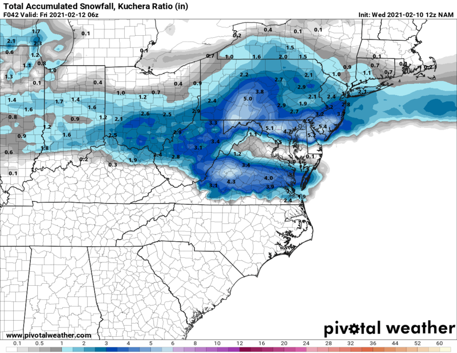
4 minutes ago, jayyy said:
Anybody able to post a quick image showing the euros trends from 12z yesterday through today? Definitely seems to be moving in the right direction. I guess the question is, is there enough time to push this sucker east enough.
One thing I’m fairly confident of - Winchester over to 15 and up to 81 are going to get smoked. Less confident about my area, as it seems to be a battle zone, and I-95 of course.
This what you were looking for?
-
3
-
2
-
-
7 minutes ago, IUsedToHateCold said:
Low heads straight up to Harrisburg PA
Ahh, the classic "Harrisburg Hauler" track!
-
3
-
17
-
-
Great, 28 and freezing mist. The roads generally look good, so I hope it holds. I need daycare to be open tomorrow - can't do this another day...

-
3
-
-
Just finished "pushing" 1-2 inches of sleet off driveway and sidewalks. I prefer the lighter snow...
Sun peaked out briefly and temps rose to 31.5...back down to 29.8.
-
1 minute ago, arlwx said:
Just measured 0.3" of pure sleet in Arlington VA.
Thanks for doing that for me. Didn't feel like getting dressed to go out and get pelted by small hail

-
1 minute ago, flsch22 said:
over one inch of ice! hope that was a typo. otherwise, better find some candles and prepare to lose power for days
Usually these sections are pre-filled text that they select as an option to include during the creation of the product. However, forecasters can free hand additional information, so either we found a bug OR we hope it was a typo!
-
24 minutes ago, Wetbulbs88 said:
Wow 32.5? I doubt I'm there and I'm in Chevy Chase...Just a terrible cold rain here, not even sleeting anymore.
Yup, it's just a sad, cold rain over here, across the river. Got a coating of snow on the grass, a little sleet and now just rain. 32.5 since like 7pm... figures
-
Solid rain/sleet mix at 32.5°. Awesome.
-
1
-
-
12 minutes ago, Eskimo Joe said:
DCA reports M0.6" snow.
Source: https://nwschat.weather.gov/lsr/#LWX/202102110000/202102110000/0100
Are we sure they didn't miss a 0 in front of that 6?
-
1
-
-
Really coming down here in Arlington. Just drove from East Falls Church to Roslyn and back to get the kiddo at daycare and minor elevation changes are really noticeable. Mostly rain near the river, with a few flakes, but as you head back up I-66, turns to solid snow by Ballston. Grass and elevated surfaces are starting to cave here.
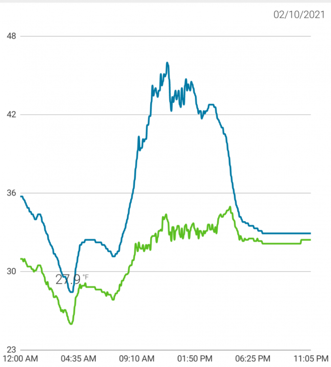
34/32 - was 41/30 around 4pm.
-
1
-
-
42 / 32 and snow coming down in Arlington *shrug*
-
41 minutes ago, wtkidz said:
Okay I don’t post much .
is it correct I don’t know or care. I am just tracking the storm.
DC folks when the storm misses south: It will trend north
Also DC folks: This solution will 100% trend north
-
1
-
-
6 minutes ago, jaydreb said:
The first wave. Lol this map is all over the place.

Ah, the famous Laurel bullseye!
-
1
-
-
I am loving all the Freezing Rain discussions! It takes me back to my undergrad research project and a journal article that I found particularly helpful at that time in understanding the subject much better. No analysis of the current setup here - just simply putting this out there for others to read if they have time.
https://journals.ametsoc.org/view/journals/wefo/19/2/1520-0434_2004_019_0377_aaofrf_2_0_co_2.xml
-
7
-
-
1 hour ago, MN Transplant said:
You did a lot better than me, just to your west (0.50" total). And DCA got 0.49" to your east. Good banding.
So I checked other stations in the area. Almost all of them had 0.20 - 0.25 for the initial precip, so we're good there. The main difference is what accumulated and melted in the rain gauge. Looks like others were in the 0.50 - 0.65 range for totals. Maybe mine collected more snow? It is off and above the back deck, not under trees, so fairly representative. Not sure, but I am getting tired of issues with my station anyway and am on the verge of getting a new one...


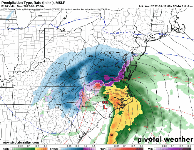
January 16-17, 2022 MLK storm obs/now cast
in Mid Atlantic
Posted
We bottomed out at 11.7. Station is elevated 2-3 meters off ground, 20 feet away from the house, so I it's legit!