

e46and2
-
Posts
135 -
Joined
-
Last visited
Content Type
Profiles
Blogs
Forums
American Weather
Media Demo
Store
Gallery
Posts posted by e46and2
-
-
the snow always sticks if it falls hard enough. a lot of you will be surprised, we go through this all the time. if streets are wet, it isn't snowing that hard.
-
 1
1
-
-
2 minutes ago, TheDreamTraveler said:
Hearing these reporters telling you to make sure you boil your water due to a boil water advisory and then seconds later say how so many people still have no electricity is just really funny. You can't boil water without power unless you have something that can heat up water like propane tanks etc which not everyone has
many people have natural gas appliances. not sure what the breakdown is down there but very common still up here. all you need is a match or lighter.
-
1
-
-
9 minutes ago, wxeyeNH said:
As of 545pm east time I still have not seen any storm chaser video that is showing true high end Cat 3 conditions. I am just comparing some of the Youtube videos of past major storms. Maybe no ones position if directly under the worst of the eyewall. Reed Timmers video in Houma definitely has not shown true near white out conditions as we saw many times with Michael. Ida's radar and satellite presentation is so impressive so chasers must be just missing the inner eyewall.
there aren't many good "options" in the ne part of this storm until it gets north towards NOLA and i suspect that's why. simply too risky in such sparsely populated and mostly wooden structured areas and wetlands.
-
around 3 inches otg with mod to heavy snow in commack
-
light snow has begun here in commack. 35/27
-
2 minutes ago, gravitylover said:
IMO it's sort of important for someone to have an idea of where an event is occurring which is pretty much the point of an observation in an obs thread. No?
")
too defensive.
-
3 minutes ago, gravitylover said:
Well that was quick. First flakes happening now. 1,600 feet north of the Westchester/Putnam border.
Location:Mahopac NY @ 709 feet
please be more specific about your location.
-
 1
1
-
-
Just now, MJO812 said:
Forky stated how he thought this storm was going to be more northwest which can still happen but we are running out of time.
The models have been awful with this storm.
This looks like a few inches to me
wasn't an insult to forky, simply pointing out how this was never an obvious forecast for those thinking the outcome has been locked in for days.
i wouldn't say awful. they vary quite a bit for sensible weather in our tiny geographic area of the world, but the reality is the overall synoptics are only shifting slightly. the chance you take being on the razor's edge.
-
1
-
-
2 minutes ago, jfklganyc said:
They have been spot on.
You just dont like what they are telling you.
There hasnt been one storm that occurred or didnt occur that wasnt accurately modeled when within the proper range of the model.
This is a scraper. Has been for days. This forum is trying to make this Blizzard Part 2. You will be disappointed if you do that.
3-6 inches. If we are lucky.
this was not obvious to anyone in the way you are making it seem. red taggers have been waffling for days on this storm as well, with forky warning it could come further NW and threaten coastal sections with rain.
i agree people like to see what they want to see, but to imply this has been a "scraper" for days isn't totally fair. we are simply reaching that consensus now.
-
4
-
-
Just now, LibertyBell said:
also "we are all in this together" is a cliche, clearly certain outcomes affect some a lot more than others.
"The median income for a household in the township was $136,174, and the median income for a family was $146,254."
godspeed, Mendham.
-
3
-
-
Just now, sctvman said:
a bit melodramatic
-
2
-
3
-
-
Just now, jm1220 said:
There's been a sucker hole over S Nassau for a while. Hopefully that fills in soon.
if we hold onto snow, this has a good look to me on the loop
-
quick measure around 13" here in commack/kings park border. mod snow continues, no sleet yet
-
1 minute ago, allgame830 said:
Reading some from the NE forum many seem to think that the models have over corrected too far NW and will come back some to SE....
i think this just proves we have a generally negative outlook as a group. just about everyone on the forums wants the snow, and [almost] everyone has doubts for their backyard
-
 1
1
-
-
3 minutes ago, HeadInTheClouds said:
the Euro is on board. Im not being arrogant either I just think the GFS is a garbage model.
i guess we differ about what onboard means. it still has a major snowstorm for nyc metro...
-
Just now, HeadInTheClouds said:
But the confluence peeps. The GFS will save us. Sarcasm.
i would be careful with the arrogance at this point in the forecast range. i'd never be comfortable about a forecast until the euro comes onboard.
-
1
-
-
2 minutes ago, HVSnowLover said:
Yea it’s brutal to live at the coast. Great stretch 2010-2014 but other than that yuck.
lol. obviously said by someone who doesn't live on the coast. we've dominated the decade here in the long island snowbelt of the north shore.
-
1 minute ago, wizard021 said:
Storm is losing intensity each run and more strung out by 12z Thursday. Looking like 6 to 12 area wide. Qpf only 1.3 yesterday was over 2.
pdii had a min pressure of like 1010mb. this is about gradient with the high, and thermal overrunning, both of which should produce a storm more intense than the minimum pressure may suggest.
-
2
-
-
8 minutes ago, weatherbear5 said:
It ain’t lack of precip. 1.5-2.0+ inches liquid from Tappan Zee East.
Some kinda sneaky warm layer
models never have proper graphic representation for long island p-types. we have a fairly predictable microclimate that those who live here are familiar with. this is a perfect setup for long island west of route 112 and north of sunrise highway. winds stay north of due east at it's worst, and gain a more northerly component as the storm tracks ene.
-
1
-
-
1 hour ago, brianc33710 said:
The pressure is still very high for a 145 mph hurricane.
does it have to do with it being october? since gradient is what creates wind, i imagine overall atmospheric pressure is higher in october compared to august, but not sure if this is a contributing factor.
-
1 minute ago, justinj said:
His location is in Commack and I’m working about two miles away from Commack and it was nothing impressive at all
we had a few gusts that seemed to be around 50mph.
-
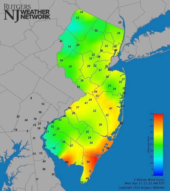
2 minutes ago, Allsnow said:
Looks like the worst of the wind is staying to the southeast of the metro and hugging the coast. Wind has not been very impressive here.

11:22am
you'll see what you wanna see though
-
1
-
-
25 minutes ago, bluewave said:
Why do people drive into floods like this?
https://twitter.com/ABC7NY/status/1044665439123574784?s=20
easy way to sell your car for blue book --- the insurance way
-
2 minutes ago, the ghost of leroy said:
It’s just nyc posters doing their thing. We have to accept that because the staff has no interest in ending the 15 year old tradition of them ruining every EC threat.
i would suggest to lighten up. this began as a valid comparison, simply to highlight the potential impact from Florence despite the weakening trend. then there was an effort to clampdown on the sandy comparisons, and we see what good that did. this is a banter thread, after all, and the comparison was always about Florence.
now we are just having a good time at the expense of those who were initially sensitive about the comparison. the initial intent was to highlight the continued danger of florence.
")
-
1
-
2/13 Significant/Major Winter Storm Discussion & Observations
in New York City Metro
Posted
powells cove? nice neighborhood