

downeastnc
-
Posts
9,330 -
Joined
-
Last visited
Content Type
Profiles
Blogs
Forums
American Weather
Media Demo
Store
Gallery
Posts posted by downeastnc
-
-
Pitt County had almost 9" in places and widespread 5-8" totals, many roads underwater this morning and even some washed out....most of it fell in 5-6 hrs. Dozens of water rescues last night as roads flooded and trapped people.
This has led to widespread flooding across portions of Greene, Pitt, and Martin Counties, with MRMS maximum ARIs of 70-90 years. In other words, there is roughly a 1% chance of an event like this occurring in any given year, making it a notable flash flood event. What`s more notable is that last night`s event was not associated with any tropical system.-
 1
1
-
 1
1
-
-
took 15 mins to get everything completely covered....now its a wait and see game to see how it plays out in the central coastal plains.
-
3
-
-
12 minutes ago, HKY_WX said:
This what i'm thinking currently. Will update with some totals tomorrow night. I don't expect any dramatic jumps with this system at this point as the pattern doesn't dictate such, but a trend NW as we get near gametime wouldn't be unexpected (if not expected given the last 2 systems of note). I've noticed the GFS has had a bias of overshearing STJ waves recently until it self correct within 72 hours. This is one reason for the last minute corrections we've seen with some of the models. From an NC IMBY perspective, my location of Choice would be somewhere around Greenville NC to Kinston NC. Not sure I would expect historic snowfall but moderate to major for that area in NC. The totals in LA/Southern MS/AL could be historic however.
Hope your right lol....this is the setup I look for to get 6-12" out of....
-
3
-
 1
1
-
-
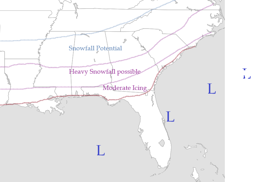
Euro smack job for eastern half of NC....I95 to Hwy 17 with foot.
-
2
-
-
2 hours ago, andyhb said:
Now 57 dead in Buncombe Co. alone via local sheriff.
Sounds like they have well over 100 bodies that have not been identified etc and they are only adding to the death toll when they do ID and notify next of kin. A guy on the hunting forum for NC I am on said they think the actual number will be much higher....a lot of people tried to flee in the vehicles and got caught in the flooding and washed away etc and it will be weeks or month before they find all the victims.
-
Makes you wonder how many times this happened and the people did not get out of the way etc....fear the deaths are gonna creep up for day as they get into areas totally cut off right now.
-
 6
6
-
-
5 hours ago, lilj4425 said:
Welp…all of the gas stations here in Greenville SC are pretty much out of fuel and the few fast food restaurants that are open are either out of food or have a line of cars at least 50 deep. The line to get gas at QT near my house was at least 100 cars deep. And don’t even get me started on the grocery stores.
After a few days of no power you wont want to go into a grocery store... upside for the SC/NC powerless is at least its not in the 80-90's everyday for the next few days. Folks down in GA/FL will be without power for a week in the humid hot weather.
-
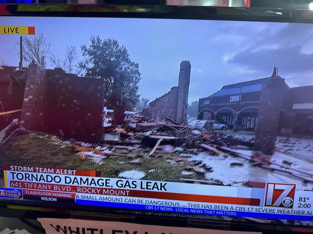
8 minutes ago, eyewall said:
Tor north of Rocky Mount NC caused this:
-
1
-
3
-
-
This is bad bad bad
-
5
-
-
Confirmed tornado on ground north of Rocky Mount NC...
-
2 minutes ago, BooneWX said:
Well.
the gulf coast dreads the “I” names and I suppose the Carolina’s will forever dread the “H” names.
For NC its the F names, Fran, Floyd, Florence.
-
2
-
 3
3
-
-
Pretty sure this is unprecedented
-
 1
1
-
2
-
1
-
-
Well then....
-
Apparently the dam is overtopping and eroding the foundation of the dam....
-
3
-
-
Charlotte already gusting over 50....
27 05:52 E 25 G 52 3.00 Rain and Breezy BKN016 OVC024 75.9 71.1 85% 76 29.46 998.1 0.05 -
2
-
-
1 minute ago, strongwxnc said:
Good lord this is a large system!
Gusting to 25 here for now.
Its also not really moving N or NNW yet either, and every hr it doesnt it gets 30 miles further into areas that were not expecting what they are about to get...if it does not really start to get captured soon it could get really close to Charlotte in 4-5 hrs....
-
1
-
-
Run this loop is about to be lights out for most of western and central SC....
https://weather.cod.edu/satrad/?parms=subregional-Carolinas-13-24-0-100-1&checked=map&colorbar=data
-
2
-
-
So that would be pretty impressive....Valdosta 102 gusting 133
-
1
-
-
14 minutes ago, StantonParkHoya said:
What are TC examples of low SLP with modest winds?
I was in the SW eye of Isabel and the pressure was 970mb and peak wind gust for the event was 51 mph....though on the NE side of the huge eye they got absolutely hammered with gust into the 80-90 range at the same time...but in our case the pressure did not indicate our winds, in Fran for instance our pressure never got close to 970 but we gusted to 110..
-
3
-
-
Just now, wncsnow said:
Here you go

Peaked at 877
-
 1
1
-
-
Ukie....and this is 10:1 probably do better than that even.....

-
2
-
-
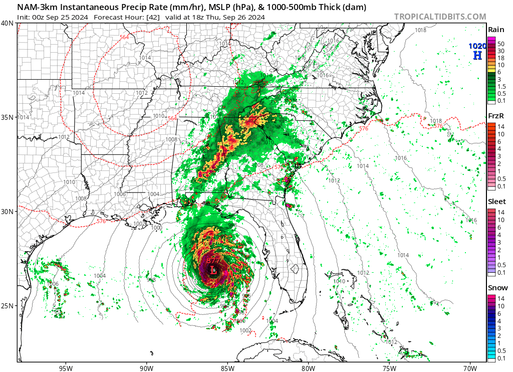
1 hour ago, eyewall said:
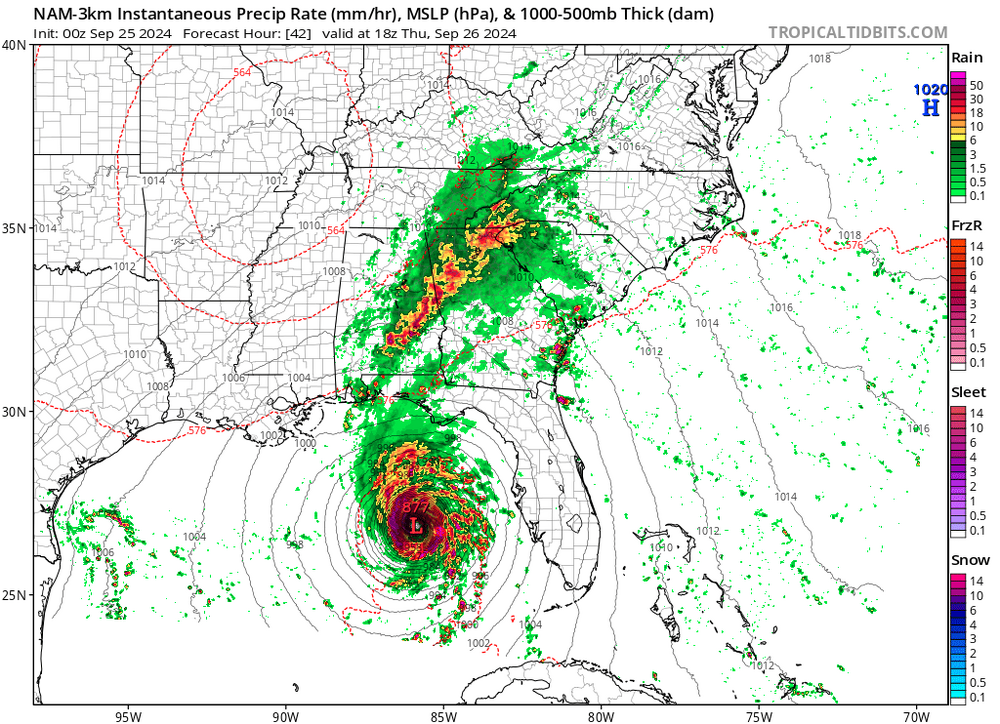
Need to see this slow down just a little bit more, the 6Z GFS spitting out insane ratios for PGV....we get 3" in 3 hrs with .11" QPF....just a few more hrs of that and we would be golden....
assuming of course the GFS has this right....the GFS is so close to this being a much bigger deal.
220122/0500Z  47  36011KT  24.0F  SNOW   19:1| 1.1|| 0.00|| 0.00|| 0.057   10:1|  3.6|| 0.00|| 0.00|| 0.37  100|  0|  0
220122/0600Z  48  36010KT  23.8F  SNOW   23:1| 1.4|| 0.00|| 0.00|| 0.061   12:1|  5.0|| 0.00|| 0.00|| 0.43  100|  0|  0
----------------------------------------------+----++-----+-------------++--------------++-------------++-----------+---+---
220122/0700Z  49  36012KT  23.6F  SNOW   13:1| 0.7|| 0.00|| 0.00|| 0.053   12:1|  5.7|| 0.00|| 0.00|| 0.48  100|  0|  0
-
1
-
-
3 minutes ago, burgertime said:
I'm really curious what happens Friday it looks like this could be the rare case where it isn't just cold air chasing moisture especially for CNC and ENC. It may be a little surprise thump.
Also due to the cold front one of the NAM doesn't really mean anything at the end of the day, just looks about right. Still think that shield of precip is probably bigger than NAM is showing but that may not help too much.
While this sucks for a lot of people this is exactly what we down here in eastern NC like to see in this range.....better cold and not phased and hope for a late bloomer, than watching it amp up and cut and give us rain again....its how we snow big, a lot can still change between now and Friday, and the NAM is all alone right now with this big of a whiff.
-
4
-
-
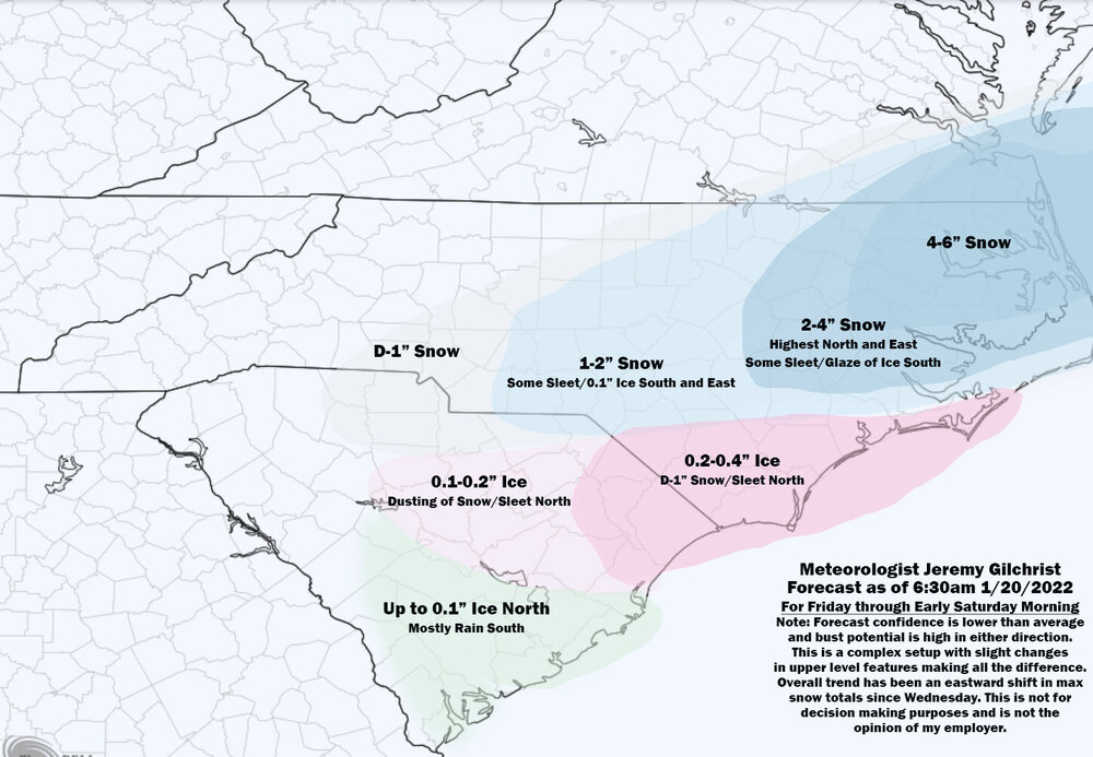
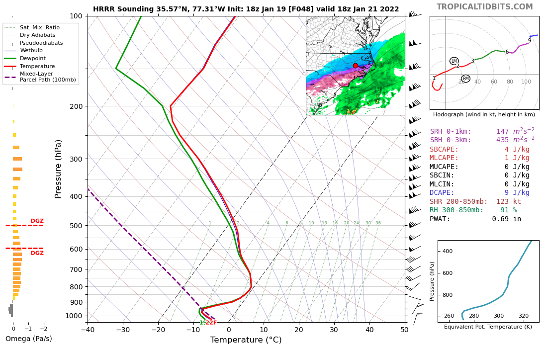
Need that SN/IP line to drift another 50 miles south to really make me feel safe....insane 22 at the surface......

-
2
-


June 2025 obs
in Southeastern States
Posted
PGV has 90/82 with a HI of 113 at 945 am.....