BornAgain13
-
Posts
4,464 -
Joined
-
Last visited
Content Type
Profiles
Blogs
Forums
American Weather
Media Demo
Store
Gallery
Everything posted by BornAgain13
-

February 19-20 Major Winter Storm Threat
BornAgain13 replied to NorthHillsWx's topic in Southeastern States
Thank you! That's so cool! -
February 19-20 Major Winter Storm Threat
BornAgain13 replied to NorthHillsWx's topic in Southeastern States

-
February 19-20 Major Winter Storm Threat
BornAgain13 replied to NorthHillsWx's topic in Southeastern States
Bermuda going to be under a winter storm warning? Lol -
February 19-20 Major Winter Storm Threat
BornAgain13 replied to NorthHillsWx's topic in Southeastern States
I mean. Realistically, how far south and east can it go? -
February 19-20 Major Winter Storm Threat
BornAgain13 replied to NorthHillsWx's topic in Southeastern States
Still showing a several or so up this way. Was just saying it's trending in the wrong direction. Meaning if it keeps trending this way, we won't be getting much of anything lol -
February 19-20 Major Winter Storm Threat
BornAgain13 replied to NorthHillsWx's topic in Southeastern States
I guess the Euro isn't the king anymore. The GFS has tampered expectations the whole time and we and myself included were writing it off in some ways... -
February 19-20 Major Winter Storm Threat
BornAgain13 replied to NorthHillsWx's topic in Southeastern States
Models definitely trending in the wrong direction even up this way. Wow what a change. -
February 19-20 Major Winter Storm Threat
BornAgain13 replied to NorthHillsWx's topic in Southeastern States
Does anyone have totals from the 0z AI? -
February 19-20 Major Winter Storm Threat
BornAgain13 replied to NorthHillsWx's topic in Southeastern States
Most guidance is still solid for a lot of the upper SE but we either need to hold serve or improve. The system Definitely doesn't need to speed up anymore lol -
February 19-20 Major Winter Storm Threat
BornAgain13 replied to NorthHillsWx's topic in Southeastern States
Definitely not headed in the right direction. I hope 12z comes back strong. -
February 19-20 Major Winter Storm Threat
BornAgain13 replied to NorthHillsWx's topic in Southeastern States
Yeah it looks to me it's just scooting along quickly from something. -
February 19-20 Major Winter Storm Threat
BornAgain13 replied to NorthHillsWx's topic in Southeastern States
It cut totals back right much as well. Not good. -
February 19-20 Major Winter Storm Threat
BornAgain13 replied to NorthHillsWx's topic in Southeastern States
More progressive and went east. It needs to slow down. -
February 19-20 Major Winter Storm Threat
BornAgain13 replied to NorthHillsWx's topic in Southeastern States
Euro definitely not as good as 0z. Trended more east like gfs and others. -
February 19-20 Major Winter Storm Threat
BornAgain13 replied to NorthHillsWx's topic in Southeastern States
Fwiw, the AI shifted significantly back west bringing much more QPF. -
February 19-20 Major Winter Storm Threat
BornAgain13 replied to NorthHillsWx's topic in Southeastern States
Thankful the Euro held serve and the EPS. Gonna be a fun time of tracking .. -
February 19-20 Major Winter Storm Threat
BornAgain13 replied to NorthHillsWx's topic in Southeastern States
Lol this is funny... the 0z GEFS actually looks much better than the OP. -
February 19-20 Major Winter Storm Threat
BornAgain13 replied to NorthHillsWx's topic in Southeastern States
Seems like the system is trending more progressive and quick. -
February 19-20 Major Winter Storm Threat
BornAgain13 replied to NorthHillsWx's topic in Southeastern States
GFS looks like it gets kicked out of the way very fast. Not sure why. -
February 19-20 Major Winter Storm Threat
BornAgain13 replied to NorthHillsWx's topic in Southeastern States
GFS is solid but definitely not like the Euro. -
February 19-20 Major Winter Storm Threat
BornAgain13 replied to NorthHillsWx's topic in Southeastern States
0z GFS looks a hair colder compared to 18z. Let's see what she does. -
February 19-20 Major Winter Storm Threat
BornAgain13 replied to NorthHillsWx's topic in Southeastern States
Rgem is pretty far south lol. But it is the 84 hr rgem -
February 19-20 Major Winter Storm Threat
BornAgain13 replied to NorthHillsWx's topic in Southeastern States
I'm not gonna be sleeping a whole lot the next few days it looks like lol -
February 19-20 Major Winter Storm Threat
BornAgain13 replied to NorthHillsWx's topic in Southeastern States
The ICON doesn't stick around long at all. Its a monster hit but quick. -
February 19-20 Major Winter Storm Threat
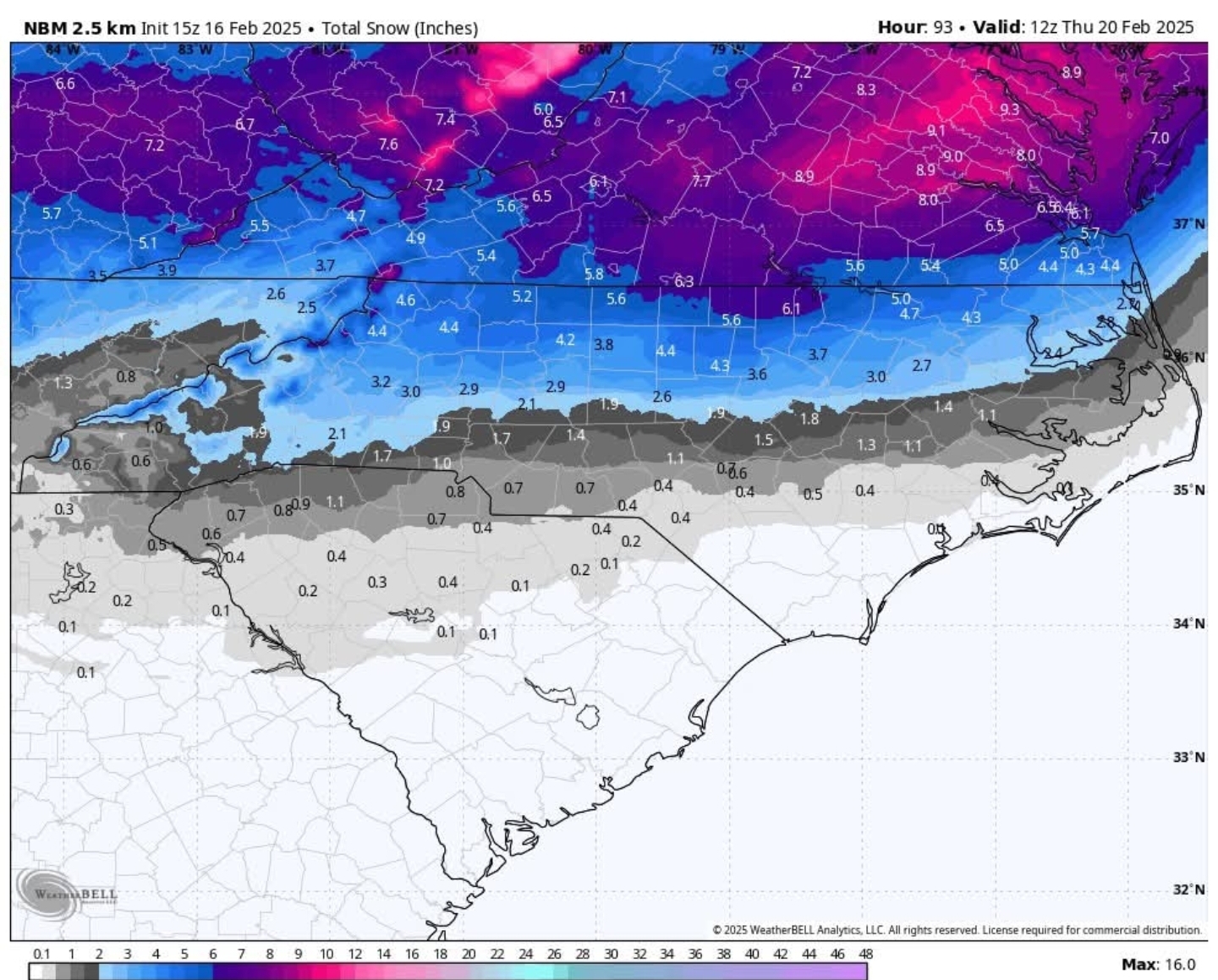
BornAgain13 replied to NorthHillsWx's topic in Southeastern States
0z ICON is colder than 18z. It brings a Major Winter Storm to a lot of folks. It brings a stripe of a Foot plus of Snow from my area to near Richmond. Snow was further south this run to