

mckinnonwg
-
Posts
150 -
Joined
-
Last visited
Content Type
Profiles
Blogs
Forums
American Weather
Media Demo
Store
Gallery
Posts posted by mckinnonwg
-
-
Possible take on the suppression south:
-
 1
1
-
-
1 minute ago, lilj4425 said:
I think I see some green over my house...if I squint really hard.
I did the best I could with my phone app hahaha
-
So you’re saying there is a chance....
-
16 minutes ago, SENC said:
I read the Whole Blog.. Nice thinking Outside the Box, considering the "upstream" ramifactions on Our Local Weather.. Thoughts on this @griteater??
Guy has solid stuff
-
 1
1
-
-
Just now, ajr said:
Fwiw
He just went all in
-
1
-
-
1 minute ago, lilj4425 said:
Anybody got the FV3 snowfall map?
Hour 81
-
1
-
-
Just now, Orangeburgwx said:
Either buried or busted... Either way it is a kiss of death
What an awesome job to be paid to head right to the center of these things!
-
2
-
-
Just now, AsheCounty48 said:
I've used it for a very long time, has some goof info on the site.
I agree. It does a very good job with the various forms of data and comparisons as well. I also have noticed that various sites have different outcomes with the same models. So it's also interesting to cross compare sites. Interesting stuff.
-
I enjoy using this page for models? Does anybody else use COD?
-
1
-
-
Overall observation is the LP exits faster on this run not leaving much QPF behind. Quicker exit with nowhere to go but EAST.
-
Precip shield looks ever so slightly more to the north at hr78 with the LP not as pronounced and hugging the coast.
-
850 temps go lower at hr69 then previous run.
-
HP looks it bit stronger for suppression on 12z
-
Thought everyone might enjoy this blog read....just more information for the masses. I enjoy reading his breakdowns.
-
1
-
-
11 minutes ago, kvegas-wx said:
Knowing the ground wont get any warmer over the next couple of days, anyone have a hotlink to a soil temp map? We're certainly not frozen, but we arent in the upper 40s either. Rates will easily overcome current conditions. (Crystal clear tonight in the triad. Cold already!)
You could try the following (0-10cm layer): http://www.greencastonline.com/tools/soil-temperature
-
-
5 minutes ago, griteater said:
StormVista
Weathermodels.com also hosts the 18z EURO
-
1 minute ago, BFF said:
As natbright posted above, it is from their hazardous weather briefing page. It is located 2/3 of the way down on the left.
Solid....I see now. Thanks
-
Just now, natbright said:
The snow total map is from GSP weather briefing. You can access it here. They put it out in the morning and evening, sometimes midday if warranted. https://www.weather.gov/media/gsp/YouTube/brief.pdf
It doesn't appear to be a static image that is found on their public site. It's probably safer that way. Just my assumption.
-
Just now, MichaelJ said:
Guys that is only until 7:00 PM saturday
They don't have a long range image or at least not one available to the public
-
Just now, lilj4425 said:
It was posted by the Greenville News. 4pm update for today .
This is the current link to the GSP site:
-
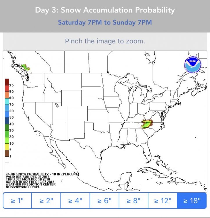
WNC is getting blasted on this run for 12+ hours
-
2
-


December 8-10, 2018 Winter Storm
in Southeastern States
Posted
Stormhamster blog update just now:
http://www.stormhamster.com/entry/e120618b.htm