

southbuffalowx
-
Posts
206 -
Joined
-
Last visited
Content Type
Profiles
Blogs
Forums
American Weather
Media Demo
Store
Gallery
Posts posted by southbuffalowx
-
-
Ripping in Poughkeepsie and the heavy band hasn't even reached yet. Eyeballing ~7" on my back deck.
There was maybe an inch at 9PM..
-
 2
2
-
-
51 minutes ago, BoulderWX said:
For a lot of people it hurts birthday and family plans. Not just about you.
I'm getting married this Saturday
 Hopefully we can salvage a Saturday this time around!
-
3
-
-
27 minutes ago, Voyager said:
I'm guessing that white vinyl fence is 6 ft high? If so, the pic of you by your shed shows only about 18 inches of fence showing. That says to me that, even with compaction, you have/had at least 4 feet of snow in your backyard.
It doesn't make sense to measure the final compacted total and call that the snow total. That wouldn't be representative of the effort put into clearing and maintaining roads, parking lots, driveways etc, if 7 feet fell but compacted into to 4 feet.
Thus you need some measurement standard to better represent what actually fell, and that is measuring every 6 hours.
-
2
-
 1
1
-
-
43 minutes ago, RU848789 said:
I'm amazed nobody is talking about potential significant snowfall for the interior NE (Poconos, Catskills and interior NY/New England and possibly even far NWNJ and the Hudson Valley) on Monday night into Tuesday - and what might it take for some snow to reach all the way down to the 95 corridor...
I'm in Poughkeepsie, so I have my eyes on it. I'm worried about any potential tree damage from the heavy wet snow.
Would trees in bloom be more prone to damage than bare trees, similar to a snowstorm in October with leaves still on the trees?
-
Pinging here in Poughkeepsie, not too much freezing rain accretion thankfully
-
1
-
-
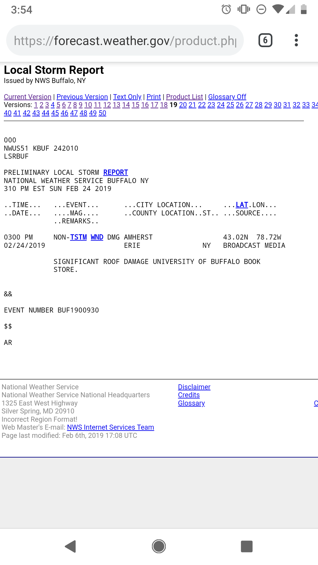
They upped the ice accretion totals for the MHV up to 0.5":

* WHAT...Mixed precipitation expected. Total snow accumulations of
  a trace to 3 inches and ice accumulations of one tenth to one
  half of an inch
I had no idea they had the latitude to issue a WWA when forecasting up to that much ice. I though the cutoff was 0.25".
Given the upgrades that have occurred through the Ohio valley, it seems likely this gets upgraded to ISW once the event begins.
-
1 hour ago, crossbowftw3 said:
12z HRRR printing out 1.3” of liquid in ZR for elevations of Ulster and Dutchess Counties, which would work to being dangerously close to the .5” marker for an ISW.
Models have been printing out 0.75-1.25" of ZR liquid across the Ohio valley where ice storm warnings are in place for 0.5"-0.75" of accretion. Using that as a guide to estimate accretion across the mid Hudson valley, it seems like we're on track for a pretty high impact event.
-
34 minutes ago, BuffaloWeather said:
You guys ready for an insane stat? The low today at Buffalo was 57 degrees. The average high for Buffalo today is 37 degrees.
64/57 was the high low today. The normal for the day is 37/26
MIND BLOWING stats
Not including today's temperatures, since they aren't finalized yet, KBUF would need to average 35.8 or warmer for the remainder of December for 2021 to break 2012's record for warmest year.
You taking the over or under on that?
-
1 hour ago, DaveTinNY said:
Semiconductors.... some of our 5g phones will be using "chips" from the machines on which I work.
")
Sounds like we work at the same place! No way I'll be making the drive either
-
1 minute ago, HVSnowLover said:
Usually when models start spitting out these type numbers there’s something to it. I’m not saying 4 feet but someone in PA or NJ I could see 2-3 feet.
For what it's worth, I recall the rgem being spot on for the forecast in Binghamton during the December storm. But it was consistent with that jackpot for 12-24 hours prior.
It also did the best job forecasting Buffalo's post Christmas LES storm. It has a pretty good track record.
-
5 hours ago, Buffalo Bumble said:
Good to see, hope it holds up! Persistence of this pattern has been remarkably annoying. Haven’t checked online, but have to think L Ontario water levels could be a problem like we had a couple years ago.
Apparently the flooding in Montreal is forecast to crest higher than 2017, which means they outflows off Ontario will have to be less than they were around the same time in 2017. Apparently that's causing a (relatively) rapid rise in Ontario's lake level.
And interestingly enough lake Erie is at a record high for the month of May right now. Or at least is above the record high average for May, so there could be some discrepancy there.
-
The next few days are looking good for me at least in the lower Hudson Valley! The weather has been very boring since I moved here.
The 12z Canadian went bonkers on me for next week. I have no idea how this place could handle 3' of snow. I have co-workers leave work as soon as it starts snowing

-
1
-
 1
1
-
-
Not in the area to expect the full blast of the winds, but we do have a high wind warning down here for the night. 60-65 mph they are saying.
Seems like some pretty widespread damage reports on the NWS site. I was particularly amused by this one, considering how much every student hates the bookstore

-
You can really see the frozen lake Erie today. Looks like the southern band should continue pushing north too, and is strengthening. I guess that's why they are leaving the winter storm warnings intact.
-
You can see it's become increasingly multi-banded, even as winds shift more to the Southwesterly.
-
1
-
-
20 minutes ago, WesterlyWx said:
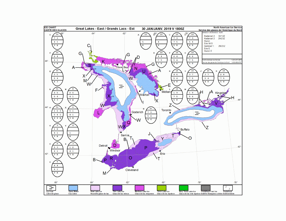
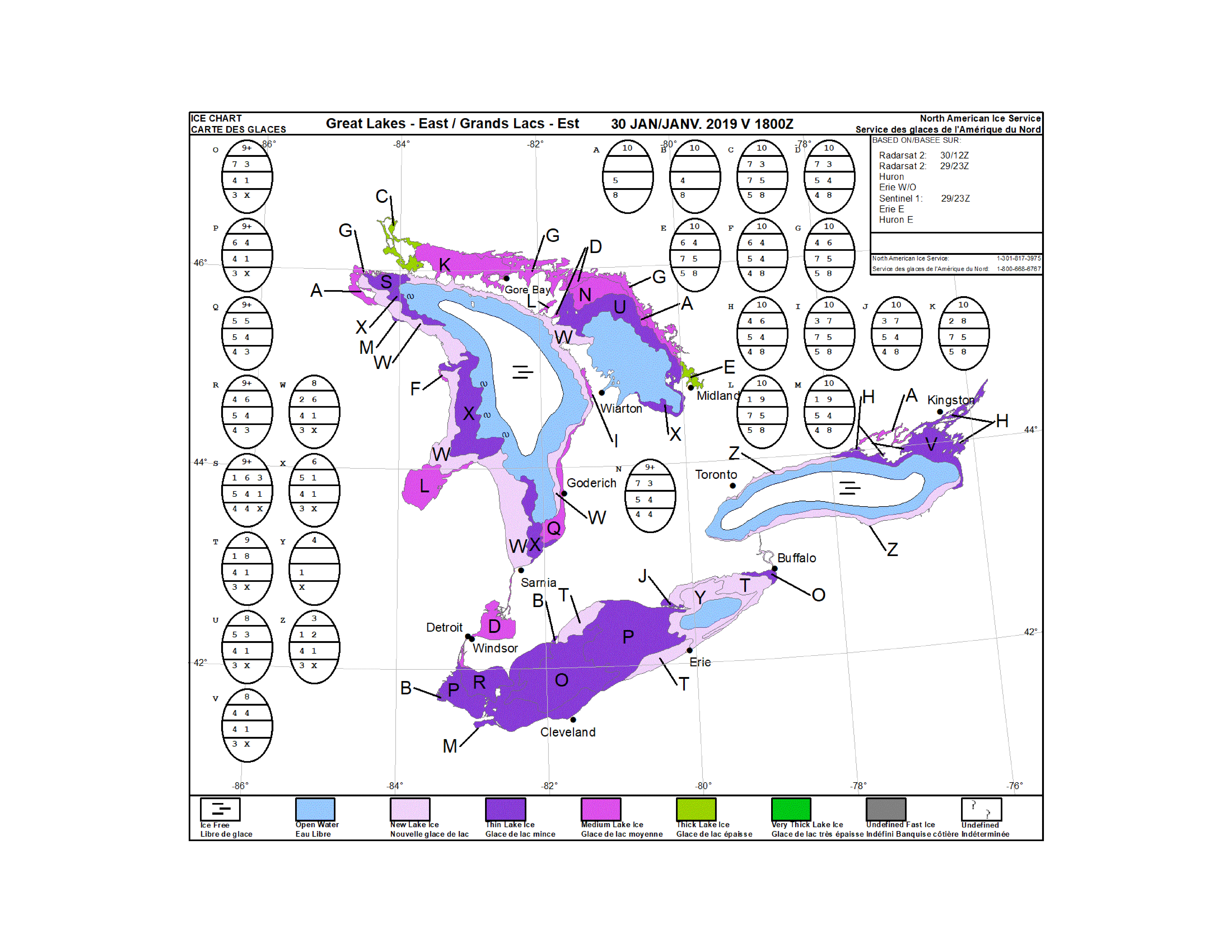
Anyone think the rapid weakening of the lake effect is from the lake rapidly freezing over with temps down to 0 or below?
Perhaps, impossible to tell from satellite imagery, but according to this map, the lake is fairly ice covered. I know we found this map to pretty suspect, but there's definitely gotta be a decent ice cover now, regardless of wind or waves.
Also maybe more dry air is working in and inhibiting the snow.
-
1
-
-
3 minutes ago, SouthBuffaloSteve said:
Looks like the bands are starting to fall apart???

.If you look at the Cleveland radar and goes satellite, you can see the shifting of the winds to a more southerly component. Should allow a more intense single band to develop. But really who knows lol
-
1 minute ago, SouthBuffaloSteve said:
Yeah dude this garbage! Watching the video from Hamburg/OP getting crushed and even downtown still getting hammered. I look out my window here... no snow no wind clear visibility and I can see those blue skies through the scattered clouds...
Measured another 2.3” so up to a 8.7” storm total but still this bites!
Man I swear whatever snow you get I get. Just measured and cleared off my board and I'm up to 8.7" as well.
This snow hole definitely blows. I'd be more than happy with a storm total of 12" now.
-
Just now, BuffaloWeather said:
Any guess as to what happens with these two bands? Combine or two separate bands?

Remain separate for several hours, leaving a snow hole in West Seneca and South Buffalo. Then they will combine, intensify and move further into the Southtowns, transitioning right through us lol

-
1
-
-
You guys in the northtowns with the 20"+ total need to report your snow to the weather service! Would hate for those high snowfall amounts to get unrecognized when they write up the report on the storms later this winter.
-
2
-
-
1 minute ago, ayuud11 said:
Dude same shit happened yesterday too WTF???
I don't think that's actually an area where it isn't snowing, just an artifact of the radar. I'm sure someone can give a more detailed reason for it's occurrence, but it always seems to be there
-
Looks like we'll have a tough time getting in on the action in South Buffalo, so I'm gonna call it a night. Hopefully that southern edge finds it's way over us when the band settles
-
Just now, ayuud11 said:
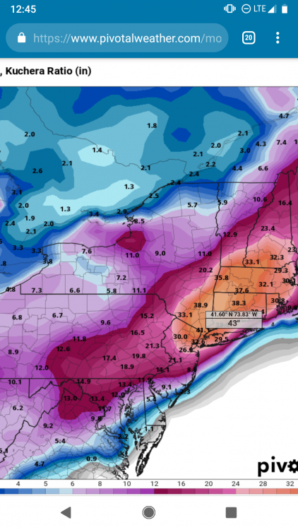
Man i keep telling you boys don't trust those Kuchera maps, you're going to be disappointed lol
Yeah, I was doing some research for determining snowfall ratios in very cold temperatures like this storm. Those 30:1 ratios the kuchera maps show ain't gonna happen, as weatherporn as it may be lol
-
3 minutes ago, WesterlyWx said:
Yeah that map seems very suspect for sure but I guess it’s possible...
Last night was very cold and calm, so I'm guessing that aided ice growth a lot. That being said, that would mean much of the ice is very thin, so if that's the case, maybe it won't have much affect at all.
It's still interesting to note, nonetheless


Two Mdt to high impact events NYC subforum; wknd Jan 6-7 Incl OBS, and mid week Jan 9-10 (incl OBS). Total water equiv by 00z/11 general 2", possibly 6" includes snow-ice mainly interior. RVR flood potential increases Jan 10 and beyond. Damaging wind.
in New York City Metro
Posted
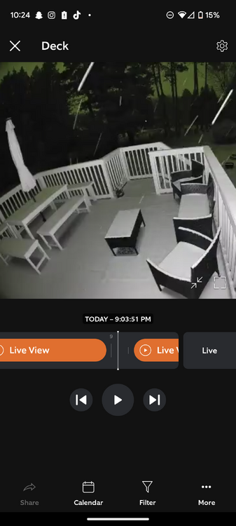
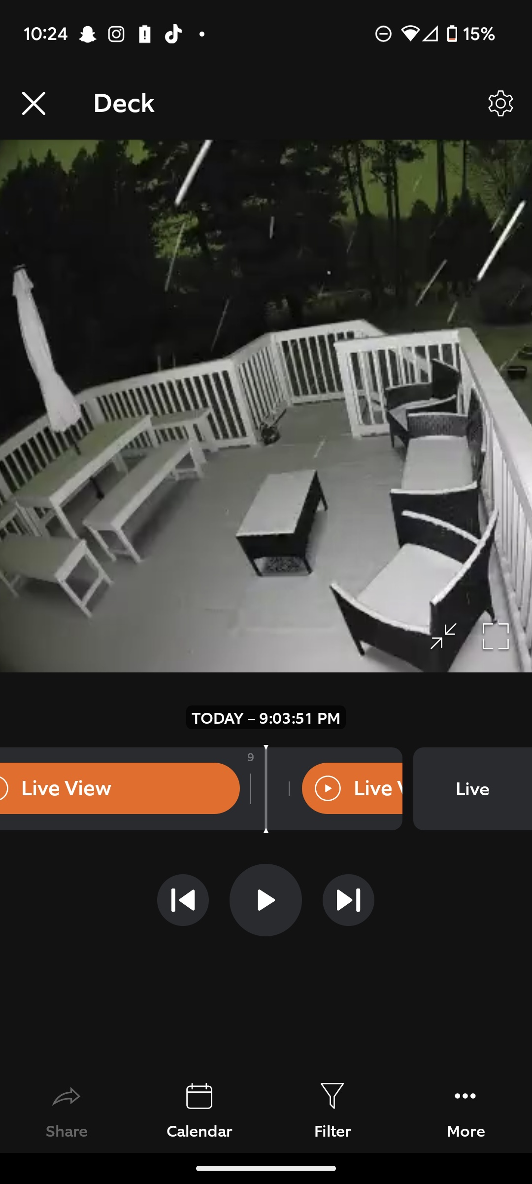
It's accumulating really well for the temperature. I didn't think it was snowing that hard until I saw my deck.
Wish I had thought to put a measuring stick on my deck. Guess I'll have to do a final total in the morning.