

Tater Tot
-
Posts
298 -
Joined
-
Last visited
Content Type
Profiles
Blogs
Forums
American Weather
Media Demo
Store
Gallery
Posts posted by Tater Tot
-
-
20 minutes ago, cheese007 said:
Wait, 50 dead at the candle factory alone? That's horrific.
-
Wow, don’t know if I’ve ever seen tornadoes explicitly mentioned like that in the forecast before (not that it hasn’t happened, just that I never check).

-
1 minute ago, OSUmetstud said:
Overweighted childhood memories became dogma.
Don't call my childhood memories overweight!
-
Reynolds Wolf just introduced the concept of a newspaper to the younguns; told them it was just like an iPad that you could throw away, which made me blurt out STFU at my TV
-
9 minutes ago, Nibor said:

Damn, that plane had barely tasted a cloud before it started huffing and puffing and making a 180.

-
 1
1
-
-
I like to watch TWC during hurricanes for the trainwreck quality but they’ve just outdone themselves. They said goodnight, I figured it was a new rotation of staff coming in, local on the 8’s started... and local on the 8’s stayed. I think they all went to bed.
There’s no coverage, just a loop of graphics and REALLY repetitive music. 10/10
-
4
-
-
omfg storm2k has an argument over the ethics of admiring powerful hurricanes every couple of hours.
-
1 hour ago, Prospero said:
Ida, she/it is trying like hell to get that hot energy from the Gulf into the atmosphere where it belongs.
What is the the cool spot? Dry air??
Leftover radar attenuation from Laura
-
1
-
-
Some random chunk of debris just came down and barely missed Stephanie and she barely even flinched lmao. She handled it like a total pro.
-
My mom just informed me that Laura made landfall at 936 megabytes.
-
4
-
-
I'm utterly shocked I haven't seen any WAP jokes in any of those live chats.
-
Chris Bruin was on earlier and I think he’s trying to move in on the Cantore gig once Cantore gets too old. He was really milking the screen time and would not stfu.
-
Whenever Cantore is listening instead of talking, he has this pained expression on his face from the stinging rain like he’s getting a rectal exam.
-
1
-
-
2 minutes ago, Hoosier said:
What would "non-quick" thoughts look like?
Few quick thoughts...
1) Comments about splitting hairs. This is a WEATHER website. To talk about the details. If we were interested in the big picture, that is, large destructive hurricane, and DID NOT care about comparing it to other storms, combing through models, wondering about this or that mesovortex, we could read NOAAs discussion or follow TWC and go on our merry way. This is a weather weenie website primarily, to discuss the details. If not here, there is no place else. That said, there is intelligent banter, and, creative banter. Throwing stuff out because you know some big words but don't know how they fit together, isn't helpful.
2) People DO see what they want to see. Some mets and folks want a weak storm. No one "wants" a strong storm, but, on some visceral level, again, no one would be here if it was a clear sunny day. Rocket scientists like big rockets. Astronomers like big telescopes. Meteorology folks are interested by severe events. The more severe, the more they're interested. That's human psychology. Everyone, deep down, looks at that car crash when they pass, trying to get a view and slowing everyone else down. Same with storms. The sheer power and awe that that causes in humans is why human's always pay attention to "bad" events. News events are the same way. Boring? bleh. Major? Bring on the carnage, where's the popcorn. Humans are a fairly savage species, and beneath all of the pleasant "oh good golly gosh I sure do hope this all goes away", when no one looks, most watch the damage, whatever that damage is. Reality shows are a giant hit for a reason. I'm not saying that to justify the behavior, but when you see people in the forum foaming over these details...that's why. Good or bad. It is human.
3) The eyewall is likely undergoing, or was trying to undergo elements of a replacement cycle. This is easy to spot. There was (until recently) a lot of lightning around the eyewall, which is a hallmark of eyewall replacement cycles. Most hurricanes do not have much lightning surrounding the eye. It is in the outer bands. Lightning around the eye, with deformation of the eye's axis, indicate instability of the eye, and possible initiation of a replacement, which seems to have started around 1.5 hours-2 hours ago. Lightning with no deformation can just indicate an incredibly strong and still strengthening storm. Here we have deformation and lightning...replacement. Almost all major hurricanes of this strength undergo one, particularly when some type of synoptic forcing mechanism is present and even more particularly after a period of rapid intensification. The degree to which Laura strengthened and the rapidity were both off-the-charts high. That means, an eyewall replacement is likely. However, once one starts, they usually take around 12 hours to complete. Within that time, you have concentric eyewalls. Typically this occurs whenthe storms surrounding the eye tighten and choke the inner circulation. That was the case earlier, but, for somewhat interesting reasons, a portion of the eye weakened to the south, in effect sort of stopping this "choking" process, BUT also, weakening the eye a bit. This leads to two possible future outcomes, either the eyewall replacement cycle will continue and the storm WILL weaken a bit before landfall, likely at a low end cat 4 strength or in a maximum reduction scenario upper 3...which has been noted by almost every single NHC update...or, the opening will slow down the process, the northern eye will continue to keep itself together and reorganize a tight southern eyewall by landfall, keeping the storm at upper 4 strength. Paradoxically, by having this opening, the storm may actually be stronger than it would otherwise be, if a full replacement cycle were able to occur. In either case, upgrading to cat 5 is highly unlikely. The SFMR winds, do not show continued strengthening, and shear is increasing a bit. This is all offset by stupid warm water temps. That's the story of this year, and it means more storms WILL follow Laura, some likely major. A wave just left Africa today. Hurricanes conceptually exist as a transporter of momentum and heat from the equator (where there is more), to the mid-lats (where there is less). The likely scenario is maintenance of category to landfall. That may disappoint all the carnal folks (see #2) that are wishcasting a cat 5 but that isn't the job of meteorologists. The job is, forecast and accurately describe the weather. Views/dreams/hopes are not relevant to forecasting and delineate the difference between the NWS, and this forum. One thing I do, when I realize I'm looking at a situation with bias in any direction, is I try to first imagine the opposite outcome happening. I want something to go one way, I imagine it does the exact opposite-weather or otherwise. That gets me out of wish mode and into objective mode. I've seen the other side of the coin so I can be more objective. So, folks, imagine for a minute before landfall this downgrades to a high end cat 2. Get out your yay's and oh noes or thank goodnesses or whatever is deep inside of you. Once you do that, come back to looking at the data, and you'll be more objective in figuring this all out.
Cheers,
Moderately Unstable
Non-quick thoughts = more pages than Les Misérables
-
1
-
-
Also I love how the relentless activity came to a dead stop as soon as everyone was told to stop bitching about the southern eyewall.
-
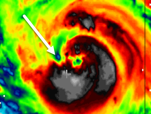
My favorite part was the debris ball in the eye thing. Now that was creative!
-
1
-
-
So can calling boats and cars by female pronouns go out of style now too? That was always cringe.
-
 1
1
-
-
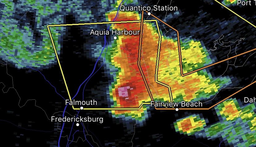
Pretty hail core!
-
Surprised this didn’t at least get one of those “Tornado possible” tags at the end of the STW.
-
2
-
-
2 minutes ago, the ghost of leroy said:
So is it going to skip Mississippi?
Grazulis levels of tornado history and World Almanac levels of geography knowledge!
-
When was the last time an outlook discussion used the term "Strong, long-track tornadoes" for an area that included Virginia?
-
1
-
-
I'm super excited for the annual finger-wagging "How can you hope for destruction?" bitchfest that seems to finally be brewing in the main thread.
-
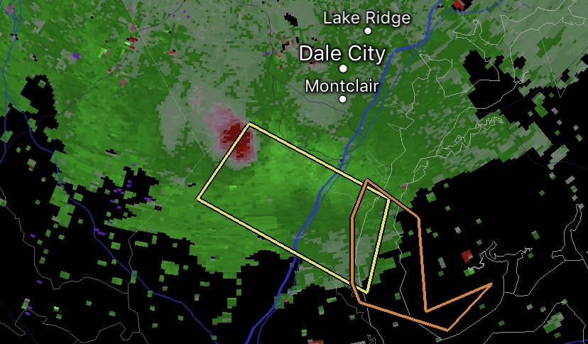
Pretty outflow boundary!
-
1
-
-

2023 Mid-Atlantic Severe Wx Thread (General Discussion)
in Mid Atlantic
Posted
Tornado Warning for Louisa. Looks like a big cell merger happening. Hopefully the meso stays just to my south.