Spartan77
-
Posts
9 -
Joined
-
Last visited


-
Pre-Christmas (Dec 21-23rd) Winter Storm Part 2
Spartan77 replied to Chicago Storm's topic in Lakes/Ohio Valley
So far with the storm here. Bands are starting to pick up in intensity again. Wind is still rippin outside.
-
Pre-Christmas (Dec 21-23rd) Winter Storm Part 2
Spartan77 replied to Chicago Storm's topic in Lakes/Ohio Valley
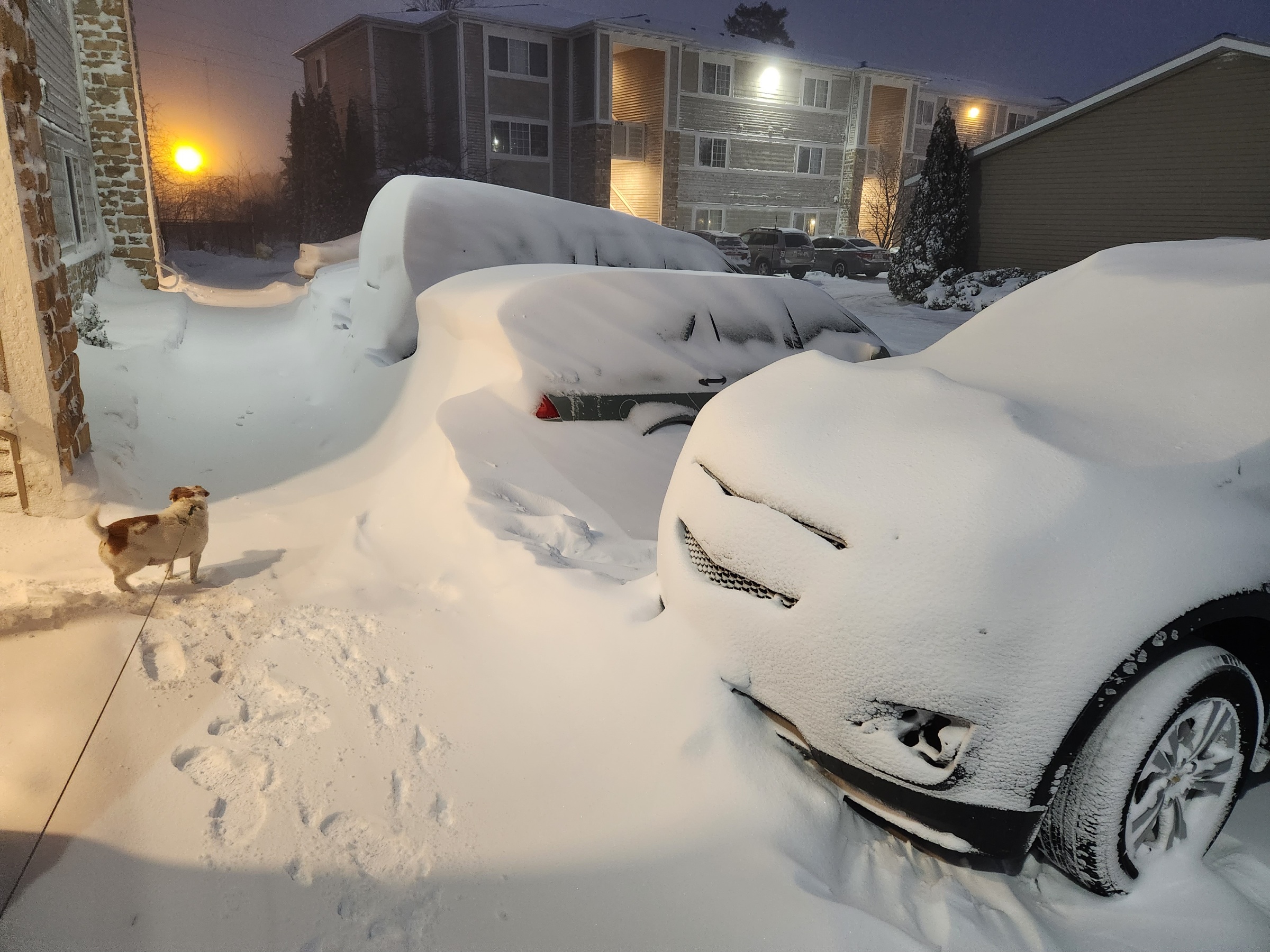
Snow and wind was pretty brutal driving from the lakeshore to Grand Rapids this morning. Although the lakeshore has heavier snow falling at the moment. Had around 3 ft snow drifts around car when I dug it out. Drive home is gonna be wild and slow. -
Pre-Christmas (Dec 21-23rd) Winter Storm Part 2
Spartan77 replied to Chicago Storm's topic in Lakes/Ohio Valley
No problem sticking here. Winds ramped up pretty quickly so the fine snow is blowing easily already. Roads are gonna be a mess in a couple hours. Thats before we even get to the worst of it. -
Pre-Christmas (Dec 21-23rd) Winter Storm Part 2
Spartan77 replied to Chicago Storm's topic in Lakes/Ohio Valley
Same here. I live a couple miles off lake michigan. Expecting some insane wind gusts. However, like previous systems, the higher snow totals will probably be right along US131 because of these winds. 1 to 2 feet aint too bad though. Drifting is going to be something I dont think I have seen. -
Pre-Christmas (Dec 21-23rd) Winter Storm Part 2
Spartan77 replied to Chicago Storm's topic in Lakes/Ohio Valley
MARINE... Issued at 305 PM EST Tue Dec 20 2022 Not much thinking has changed in terms of the storm and it associated marine impacts. There is an increased risk for freezing spray and with waves now forecast to approach 20 ft...we will need to assess the erosion risk. Confidence continues to grow on the storm force wind risk with still a small potential for hurricane force wind gusts. Would be pretty amazing to see the effects of the waves and freezing spray on the piers along the western Michigan shoreline. -
Pre-Christmas (Dec 21-23rd) Winter Storm
Spartan77 replied to Chicago Storm's topic in Lakes/Ohio Valley
.LONG TERM...(Thursday night through Monday) Issued at 241 PM EST Mon Dec 19 2022 High Impact Weather Potential: Large storm system with impactful weather to northern Michigan possible Friday-Saturday with lake effect and colder weather behind the departing system. Long term models are continuing to come together with a storm system that develops in the central Great Plains and moves into the southern Great Lakes region. There are still uncertainties in the exact track of this system, which would have a great impact on p- type and amounts. The current track would definitely produce snow with possibly a quick period of a wintry mix on the front side Friday over northern Michigan...but as stated already...still quite a bit of uncertainty. The storm at this time is forecast to drop between 27-31mb (depending on model) to become a 967-969mb surface low in a 24 hour period from Thursday night to Friday night. This is considerable strengthening (bombogenesis) as it is tracks over/near the Detroit area and up Lake Huron. This will end up being quite a storm wherever it impacts, with heavy accumulating and blowing snow and strong winds in the heart of the storm. Wind will be very strong...the GFS has the strongest wind gusts...which has hit hurricane strength along the Lake Michigan shoreline the past four runs. Regardless of this storm system`s track being either more north, south, east, or west this will be a very impactful storm to northern Michigan...possibly historic. It`s also safe to say that much colder air would move in behind the departing system by the end of the work week producing lake effect snow at times and some single digit lows behind this departing storm system. Gaylord has very strong wording on the wind gusts. Curious if that will translate further down the shoreline. Crazy reading most of these AFD's!