
osubrett2
-
Posts
385 -
Joined
-
Last visited
Content Type
Profiles
Blogs
Forums
American Weather
Media Demo
Store
Gallery
Posts posted by osubrett2
-
-
15 minutes ago, pondo1000 said:
Is CMH still on track for least snowiest January? It better be. If it’s gonna suck this bad, we may as well break records!!!!
Nope, unfortunately the airport measured 0.2" on Saturday. The record for least snowfall is a Trace, which was all we've received until late Saturday.
I'm all in for futility records now. But the one for least snowfall in a season is already out the window. To-date, we're at 5.3" and the record of 1941-42 is 4.9".
-
 1
1
-
-
18 hours ago, Hoosier said:
Looks like a period of strong winds in parts of IN/OH/MI overnight/Monday as the surface low rapidly deepens. Could even have a brief period of high wind warning criteria gusts imo. Will be curious to see if the NWS offices start to hit this harder.
Great call Hoosier. Lots of 60+ MPH gusts reported overnight with some 70+ sprinkled in too. It was so loud, the house was rattling and woke me up. ILN reacted late with an Advisory and then a Warning a few hours ago. ~100K without power across Ohio. Mine went out 1x overnight but was back on within no time.
-
 1
1
-
-
I wasn’t in Columbus, but I couldn’t have imagined tracking and forecasting this storm, let alone having to deal with all the ice across Franklin County. Crazy gradients.

-
1
-
-
The weakening and slowing trend for Monday’s storm is a good sign for most of Ohio, especially us along I-70. It allows us to cash in on a few inches of snow on the front end before warming up to rain for a bit.
-
2 hours ago, OrdIowPitMsp said:
while I’m in New Zealand for my honeymoon Dec 22 - Jan 8 you can lock it in.
58 minutes ago, SchaumburgStormer said:Risking a total thread derailment, but where in New Zealand? I was out there two years ago in January and it was awesome.
I have traveled internationally a lot, but it was one of the few places where I gave serious consideration to moving to. We priced out property but ultimately decided against it, mostly due to the costs involved in the grandparents coming out to see the babies.
Totally OT here, but I leave for my honeymoon trip to New Zealand on Sunday. Spending 6 days on the South Island, driving from Queenstown to Wanaka to Lake Tekapo to Christchurch. Taking a flight to Rotorua. Spending 4 days on the North Island, driving from Rotorua to Tauranga to Auckland. And then finishing up with 4 days in Fiji.
I would love to hear both of your travel plans!
-
2
-
-
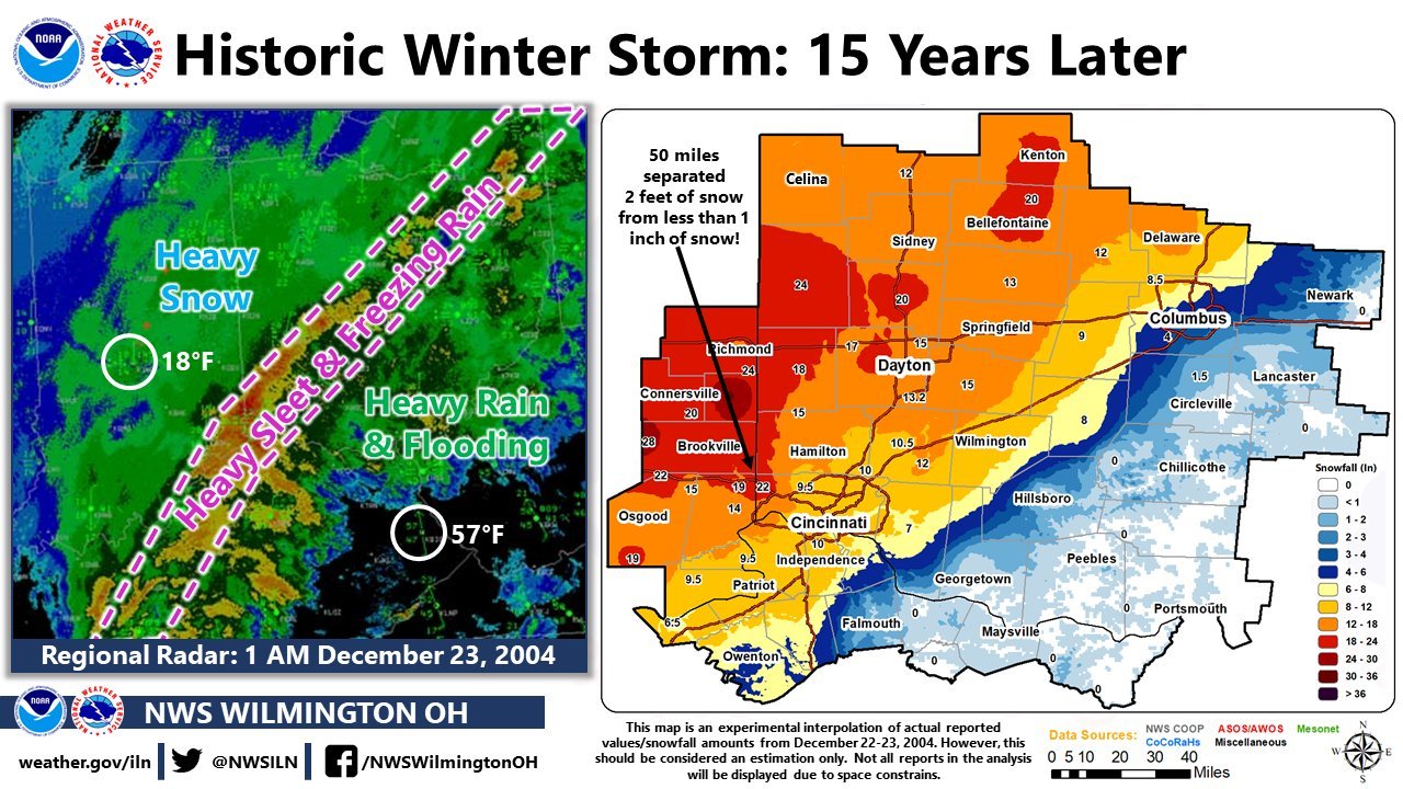
1 hour ago, BuffaloWeather said:
We got 22" from that storm. Places near Erie had over 30"
1 hour ago, RogueWaves said:That was the rare Apps running bird right there
March 2008 is an all-timer for CMH: 20.5". (5" on 3/7 and 15.5" on 3/8)
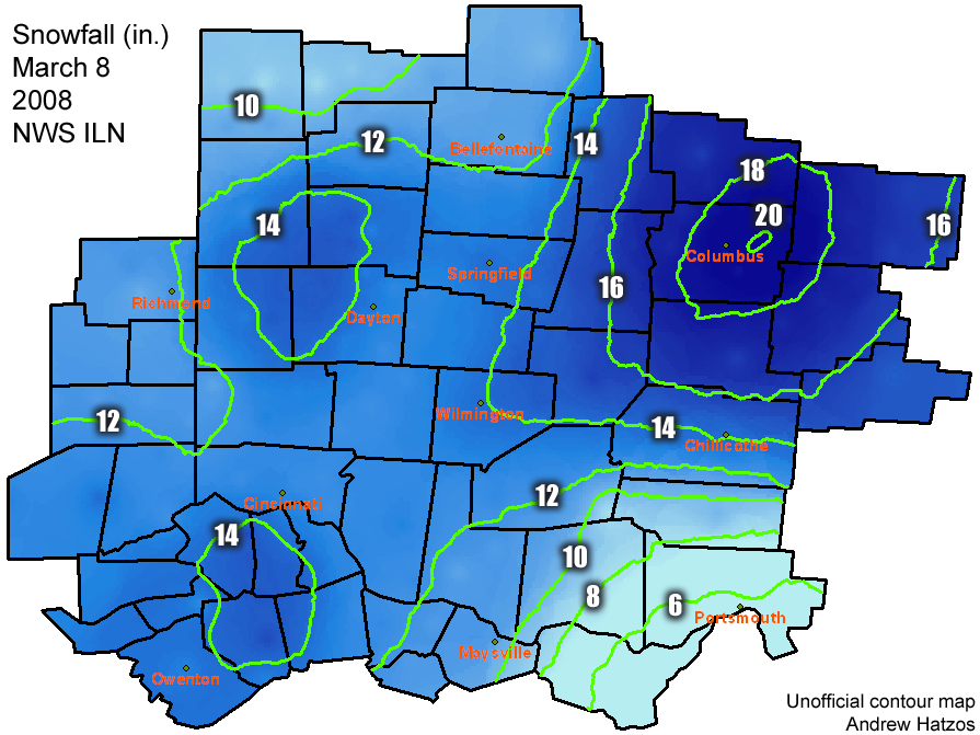
A post of mine regarding this storm from the "Top 5 Winter Storms" thread last winter:
On 11/1/2018 at 9:38 PM, osubrett2 said:It was my senior year at OSU, the end of Winter Quarter right before Spring Break. IIRC, models weren’t picking up on the storm until ~4 days out, which feels short-term today. I remember comparing the GFS vs. the NAM ad nauseum. The NAM solutions were typical clown maps and the GFS was it’s usual conservative self. With gulf lows, Central Ohio is always victim to the warm sector, but models never budged, keeping us all frozen/snow. Once my meteorology professors showed optimism, I was all in.
ILN stayed rather conservative with a 8-12” forecast. They upped it to 12-15” with the blizzard warning the morning of. (The last blizzard warning for Franklin County). Snow started around 10am and by 4-5pm, ~5-6” fell before a few hour break. I regret not staying awak for the overnight show. Woke up Saturday morning to the most snow I’ve ever seen on the ground and in 1 storm; 20.5”.
-
2
-
-
90/93/93/93 the last 4 days for CMH, which is 26 for the year. Not too bad for mid-September.
-
Overachieved with 64F at CMH today. Mostly sunny skies after some morning showers made for a great afternoon. Should easily break 70 tomorrow, would be the first time since October 11th.
-
Moderate to heavy sleet/freezing rain band just rolled through here. Got caught out walking the dog and the sleet wasn’t the typical pellet form, but rather chunks of ice. It actually stung lol. Temps are hovering right at 31/32 so we’ll see if it rises and changes to plain rain. There is some dripping off elevates surfaces, but I blame the heavy rate equally as the temps.
-
Good chance this little clipper will be CMH's biggest storm "officially". Not hard to top as the airport reported 4.0" for the 1/12 storm and 3.6" with the 1/19-1/20 "bust". Ratios will be on the upper end, as mentioned before, with the deep cold air and I-70 looks to be in the best position. I don't think this has been really mentioned much with all the talk around the cold, so likely many people will be surprised tomorrow morning.
-
CMH currently is -2 which is the low so far. Didn’t approach -7 like forecasted. However, the OSU airport bottomed out at -3, Bolton Field at -6, and Rickenbacker at -7.
-
16 minutes ago, pondo1000 said:
What about wind chills?
That is likely true, wind chills are definitely colder now than early January 2018. Those nights were radiational cooling nights after we had a clipper drop a few inches of snow right before New Years.
-
2 hours ago, dilly84 said:
Can anyone confirm. A guy arguing with me says it was this cold last winter.
2 hours ago, pondo1000 said:Never got this cold last winter.
We did. At least here in the city. 1/2 and 1/3 last year were -3 and -4. So far today we’re -4 and that was at noon. It’s actually risen 5 degrees since. As jb mentioned, we might have trouble dropping much to reach the -7/-8 forecasted here in the city. Haven’t been able to check local obs or any upper air soundings to make a true forecast.
-
Stronger and further displaced High in southern Canada pushing the Mon-Tues clipper closer to us on the GFS. Similar to the Euro, but stronger.
-
I’d estimate 5” here, which isn’t bad considering it snowed for a 5-6 hour window. The wind was pretty spectacular, had a few drifts of 2-2.5’ next to my garage which is a decent size for being in the city.
-
Crazy winds, it’s been a long time since I’ve seen winds like this with falling snow. Been snowing for 3 hours and there’s probably 2” on the ground? Hard to tell with the wind and I’m eyeballing from inside.
-
8 minutes ago, Cincy12 said:
Thunder snow!
Nice! What part of the city?
-
Sleet has now transitioned to snow.
-
6 minutes ago, dilly84 said:
Think it's time for me to write it off... still sleet 26°. And radar shows snow. Not accurate. Think it's over for me in Knox.
I definitely feel your frustration, but you should be switching to snow any time now. Radar looks great in SW Ohio and Indiana.
-
Heavy sleet here, snow is just 10 miles away.
-
Just additional evidence on how the HRRR is not completely accurate, the 0z run has 0 QPF (at 01z) across Cincinnati. An obvious check of the radar debunks that already.
-
 1
1
-
-
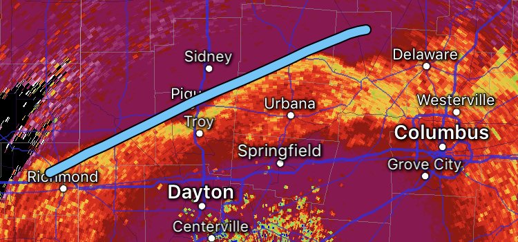
Per the 0z HRRR, 850s Will finally crash through Franklin County by 9pm. And eyeing what’s headed NE out of Cincinnati, hoping that is the beginning of a decent catch-up.
-
Sleet mixing in with rain in the city.
-
1 minute ago, buckeye said:
thats seems way too fast I'm thinking much later like 9.
Agreed. The line is taking its good ol time sagging southeast.
“Let’s Talk Winter”
in Lakes/Ohio Valley
Posted
Going through the monthly climate data, CMH has only received measurable snow on 6 days:
11/12: 2.1"
11/13: 0.7"
12/15: 1.5"
12/16: 0.7"
12/17: 0.1"
01/25: 0.2"