
osubrett2
-
Posts
385 -
Joined
-
Last visited
Content Type
Profiles
Blogs
Forums
American Weather
Media Demo
Store
Gallery
Posts posted by osubrett2
-
-
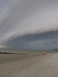
93 at DAY today

-
Friend of mine has measured 5.5” so far in Littleton. What happened that the city has missed out?
-
Is the BOU radar down? Can’t get it to load in RadarScope.
-
There are still pockets of warm air aloft that caused mixing around Dayton and now around Columbus. These pockets will cool completely overnight and moisture near CVG will move this way as snow. 850s shouldn't rise above 0C until 9-10am. That's when our risk of rain and melting starts.
-
First flakes flying here. Not completely buying the higher totals the NAM keeps spitting out, but I'm keeping a close eye on the 850 temps. NAM wants to keep I-70 and north below 0, HRRR says otherwise but may be trending cooler. But regardless, 2m temps will inhibit much accumulation between 12-6p tomorrow.
-
7 minutes ago, HighTechEE said:
Well dammit, you guys don't want to hear this, only after 1" of snow, it quit, and I don't know what is falling now, but it isn't snow at 30 degrees...
A mix of sleet was modeled by the hi-res models in this initial band. Dewpoints and wetbulbs are still below freezing, so the column still has to fully cool.
-
25 minutes ago, Gino27 said:
Yeah for sure. 1/19/19 looked like an easy 8"-12" north of I-70. I got 6" with 1.4" of liquid that day. What could've been....
I'm pretty sure the last warning before that verified would've been 3/1/2015 with a WSW upgrade during the storm, and the 2/1/19 clipper got close to warning criteria with high ratios. However, he last true watch turned warning that met criteria was 2/21/15. That's 2,166 days. ugh...
Good recall on those dates...
6” was at least a decent recovery for the 1/19/19 storm for YBY, I think I ended up with 4.5” IMBY all from the ULL after sunset. I felt pretty scorned over that bust.
2/1/19 was a nice, over-performing clipper. I didn’t officially measure, but I recall eyeballing close to 5.5-6”.
Yes our climate isn’t friendly to 6”+ storms, but going 6 years between confirmed WSWs is brutal.
-
 1
1
-
-
1/19/19 was a fairly noteworthy bust within 12 hours for south of US 36. So I’d argue the WSW drought is longer than 738 days.
-
 1
1
-
 1
1
-
-
Have done well here locally; snowing most of the day since 8am. Had a nice moderate burst in the late morning which brought MBY ~2" by 1230/1. This last round may bring MBY to 3" total.
-
1
-
-
Ohio’s numbers have looked “better” than last week, trending between 6400-7800/day. But DeWine confirmed today that ~12k cases, since Monday, are being double checked. And most of them are likely positive. So some backdating or a bulk upload will increase Ohio’s number dramatically.
-
 1
1
-
-
Record day in Ohio: 3,509. Prior high was last Saturday ~2,600.
-
ILN has the Frost/Freeze program up for most of the CWA.
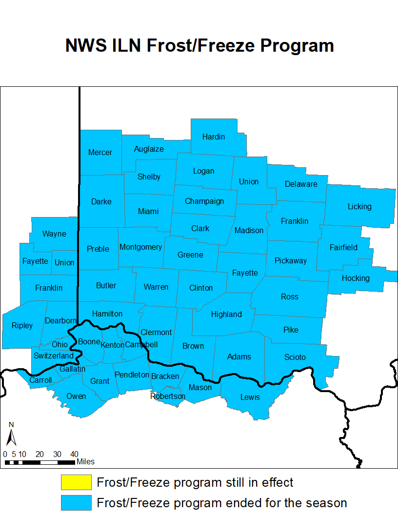
Coldest temperature so far this season:
-CMH: 33 on 10/17
-CVG: 34 on 10/17
-DAY: 35 on 10/16
-
41 minutes ago, Stebo said:
Warm Tongue of Death will be a common theme in Ohio this year.
As for the region as a whole, I expect above normal temps/precip/snow especially north of 80.
9 minutes ago, Hoosier said:Hating on Ohio right out of the gate huh.
Agree though. Generally speaking it should be a better winter (relative to average) north/west, but anybody can get a big one. A good example is the OV snowstorm in March 2008, another Nina winter.
I mean, he's not wrong. We know geography is not in our favor, but we'll still whine and complain when the rug gets swept out from under us 72 hours out.
-
2
-
2
-
-
Just a few miles makes a huge difference, as always, but heavy rain has skirted around MBY all summer.
August Month to Date:
-MBY: 1.46"-CMH: 3.32" (~6-7 miles as the crow flies)
-
Ohio had its largest single day in reported cases since the pandemic began: 1,525.
-
CMH eeked out 90 before storms moved into Central Ohio to make it 12 days in a row. Streak should end tomorrow, but it’ll be close.
90, 91, 91, 92, 93, 94, 96, 97, 97, 92, 94, & 90 -
On 7/6/2020 at 5:05 PM, osubrett2 said:
97 at CMH today, impressive.
Today makes 8 consecutive 90+ going back to June 29th; 90, 91, 91, 92, 93, 94, 96, & 97.
97 for the 2nd consecutive day at CMH.
-
97 at CMH today, impressive.
Today makes 8 consecutive 90+ going back to June 29th; 90, 91, 91, 92, 93, 94, 96, & 97.
-
1
-
-
96F at CMH today. Hottest since 97F on 8/31/12.
-
You know it’s a bad winter when ILN doesn’t even issue a Warning for the lower criteria counties south of I-70
-
1
-
1
-
-
0.8” at CMH, couldn’t even squeeze out an even inch


-
3 hours ago, jaf316 said:
When is the last time central or southern Ohio got a real, honest-to-goodness snowstorm (let's say 6+ inches)? I moved to cbus 4 years ago and have yet to see more than about 4 inches imby...
(tho at this point I'd gladly take anything...)
6.8" on 2/21/2015 was the last 6"+ event (including 2 day totals) for CMH.
Franklin County/CMH has only been under 1 Winter Storm Warning since the winter of 2014-15 and that event (1/19-1-20/2019) busted big.
-
1
-
1
-
-
Welp, yeah sorry fellas. Looked decent for a split second, but a stronger system on Wednesday ruins any chance for the OV on Thursday/Friday.
-
Might we finally have a trackable event later this week??
June 2022 General Discussion
in Lakes/Ohio Valley
Posted