MazooWeather
-
Posts
3,866 -
Joined
-
Last visited
Content Type
Profiles
Blogs
Forums
American Weather
Media Demo
Store
Gallery
Everything posted by MazooWeather
-
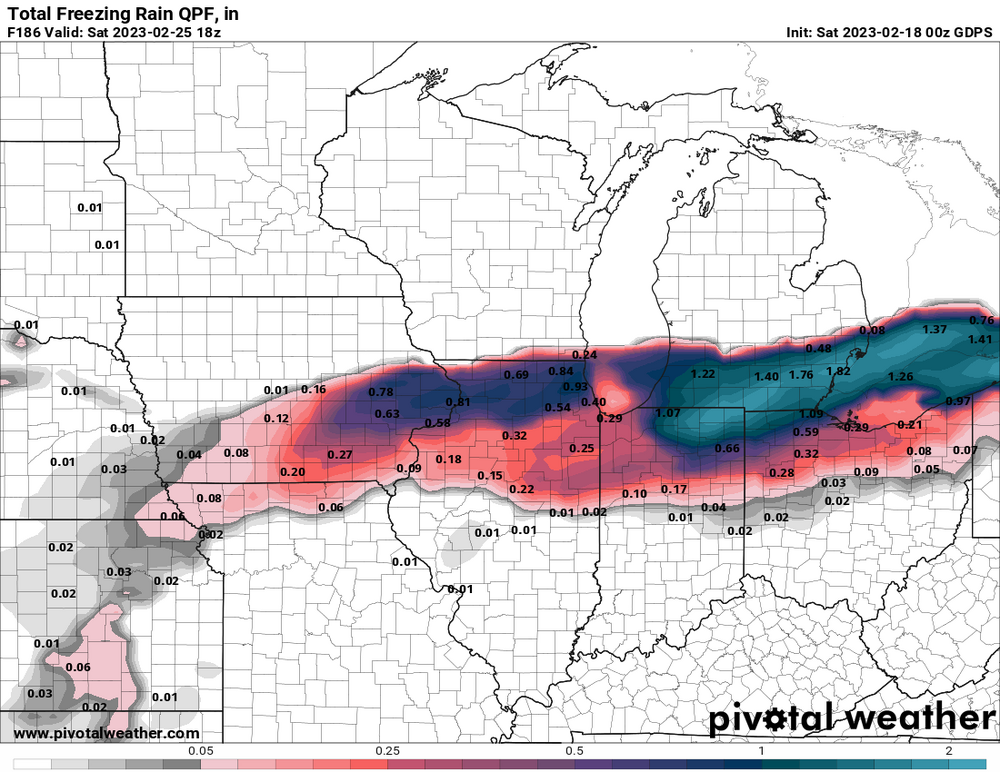
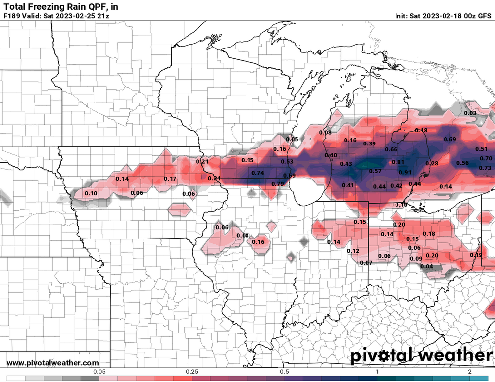
Local news stations are now calling for Hillsdale to get 0.25 to 0.5, a lot more than the current IWX forecast
-
People here might be getting a big shock going from 0.1 to whatever they might up it to
-
IWX is betting on Branch and Hillsdale only getting .1 of ice but if the south trend continues they might have to do a pretty big increase
-
It’s gonna be close here, a little shift is the difference between rain and crippling ice. If the south trend continues the ice threat will be even bigger.
-
0Z GFS looks to be a touch south in general, the model variation is gonna make for a tough forecast
-
Goddamn
-
-
Thoughts to the folks around Lansing
-
Just remember, it could always be worse, the NYC people are about to go postal
-
At this point if we're not gonna get snow can we get early severe storms at least
-

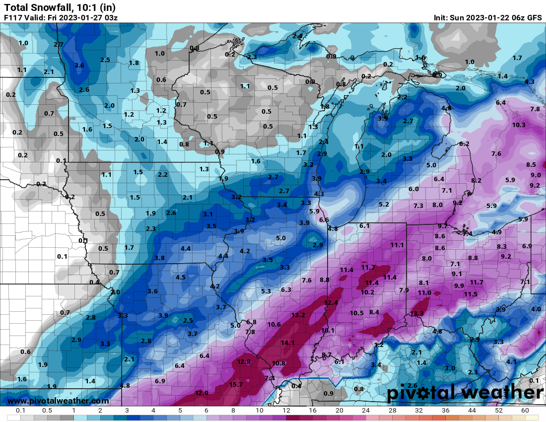
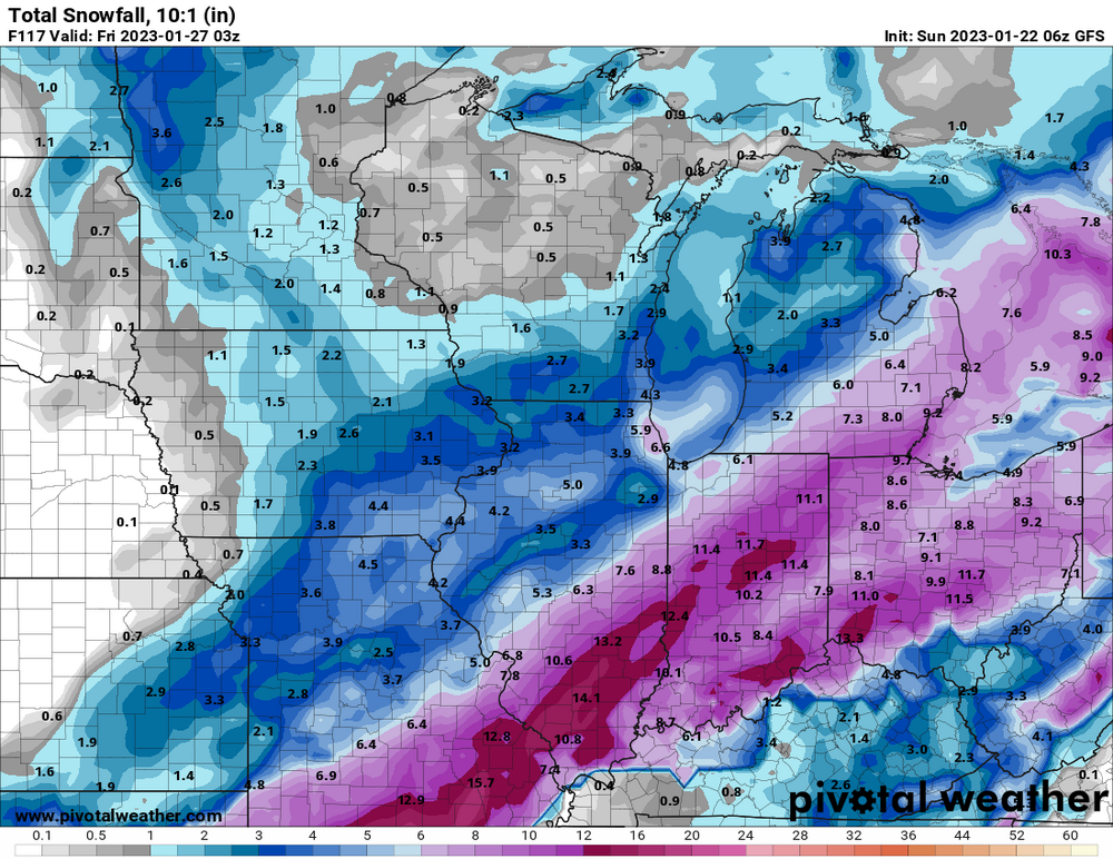
Midwest/Ohio Valley/Great Lakes Snow January 24-26
MazooWeather replied to Baum's topic in Lakes/Ohio Valley
Sitting at 7.5 here in Hillsdale, I'll gladly take it, nice little event -
Winter 2022/23 Medium/Long Range Discussion
MazooWeather replied to Chicago Storm's topic in Lakes/Ohio Valley
Sunday looking like it could be another system like the one tomorrow but more spread the wealth-y -
Midwest/Ohio Valley/Great Lakes Snow January 24-26
MazooWeather replied to Baum's topic in Lakes/Ohio Valley
-
Midwest/Ohio Valley/Great Lakes Snow January 24-26
MazooWeather replied to Baum's topic in Lakes/Ohio Valley
LOCK IT IN -
2023 Short/Medium Range Severe Weather Discussion
MazooWeather replied to Chicago Storm's topic in Lakes/Ohio Valley
A wedge dropped in Iowa -
Winter 2022/23 Medium/Long Range Discussion
MazooWeather replied to Chicago Storm's topic in Lakes/Ohio Valley
Last couple gfs runs are hinting at a clipper in a couple days, could drop a quick couple inches in spots -
The extent of the fatalities from the blizzard is way more than I think anyone expected, they're still finding people dead in Buffalo
-
2023 Short/Medium Range Severe Weather Discussion
MazooWeather replied to Chicago Storm's topic in Lakes/Ohio Valley
January 3rd could be interesting, temps in the 60s from Michigan to Kentucky -
Pre-Christmas (Dec 21-23rd) Winter Storm Part 2
MazooWeather replied to Chicago Storm's topic in Lakes/Ohio Valley
This storm has been impressive in the fact that you either busted super low or got absolutely goddamn demolished by blizzard conditions with no real in-between -
Winter 2022/23 Short/Medium Range Discussion
MazooWeather replied to Chicago Storm's topic in Lakes/Ohio Valley
If trends hold up we could see some flooding and maybe even some severe weather on new years day -
Pre-Christmas (Dec 21-23rd) Winter Storm Part 2
MazooWeather replied to Chicago Storm's topic in Lakes/Ohio Valley
fwiw GRR thinks the lake effect will be pretty damn strong later today in their new AFD once the pressure gradient really kicks in -
Pre-Christmas (Dec 21-23rd) Winter Storm Part 2
MazooWeather replied to Chicago Storm's topic in Lakes/Ohio Valley
Some of the stuff from the southwest will wrap around it looks like -
Pre-Christmas (Dec 21-23rd) Winter Storm Part 2
MazooWeather replied to Chicago Storm's topic in Lakes/Ohio Valley
Chicago jumped from like 1 inch to 6 inches, clawing their way back no matter what -
Pre-Christmas (Dec 21-23rd) Winter Storm Part 2
MazooWeather replied to Chicago Storm's topic in Lakes/Ohio Valley
GRR held off on expanding any headlines, I think they might in the morning -
Pre-Christmas (Dec 21-23rd) Winter Storm Part 2
MazooWeather replied to Chicago Storm's topic in Lakes/Ohio Valley
IWX just expanded the blizzard warning one county to include Saint Joseph MI